This article is about the Lebanese river. For the WWII battle, see Battle of the Litani River. For the South American river, see Litani River (South America).
Litani River
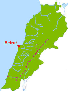
The Litani River in maroon, the Lebanese capital city Beirut in red
Location
Country
Lebanon
Physical characteristics
Mouth
Mediterranean Sea
The Upper Litani Basin (ULB)
The Litani River (Arabic: نهر الليطاني, romanized: Nahr al-Līṭānī), the classical Leontes (Greek: Λεόντης, translit. Leóntes, lit. "lion river"), is an important water resource in southern Lebanon. The river rises in the fertile Beqaa Valley, west of Baalbek, and empties into the Mediterranean Sea north of Tyre. Exceeding 140 km in length, the Litani is the longest river in Lebanon and provides an average annual flow estimated at 920 million cubic meters.[1][2] The waters of the Litani both originate and flow entirely within the borders of Lebanon. It provides a major source for water supply, irrigation and hydroelectricity both within Southern Lebanon, and the country as a whole.
^"LEBANON, Water resources". FAO UN. Archived from the original on 6 June 2015. Retrieved 4 November 2019.
^"The Characteristics of the Litani River". The Litani River Authority. Archived from the original on 5 October 2018. Retrieved 4 November 2019.
The LitaniRiver (Arabic: نهر الليطاني, romanized: Nahr al-Līṭānī), the classical Leontes (Greek: Λεόντης, translit. Leóntes, lit. "lion river"), is an...
Lebanon conflict (codenamed Operation Litani by Israel) began after Israel invaded southern Lebanon up to the LitaniRiver in March 1978, in response to the...
The Battle of the LitaniRiver (9 June 1941) took place on the advance to Beirut during the Syria-Lebanon campaign of the Second World War. The Australian...
dictionary. Litani may refer to: LitaniRiver (Nahr al-Līţānī; from Greek: Λέοντες Leontes), a river in Lebanon Battle of the LitaniRiver (1941) 1978...
dam (the largest dam in Lebanon) in the middle reaches of the LitaniRiver (longest river in Lebanon). The reservoir has been used for hydropower generation...
The LitaniRiver Dam (el Wauroun Dam, Qaraoun Dam, or Albert Naqash Dam) was initiated in 1959 (construction completed in the 1960s), and created the largest...
was to cross the Saluki stream to direct additional forces towards the LitaniRiver. The decision to cross the stream came from the High Command after United...
ten-kilometers-wide except for a salient which reached north to Jezzine and the LitaniRiver and put Tyre and Sidon as well as the Beqaa valley within artillery range...
members of cabinet said that their militia would not disarm south of the LitaniRiver, according to another senior member of the Lebanese cabinet, while a...
Marj Ayyun was a military confrontation fought at Marj Ayyoun near the LitaniRiver (modern-day Lebanon) in June 1179 between the Kingdom of Jerusalem under...
Campaign. Mayne successfully led a section of men during the Battle of the LitaniRiver in Lebanon against Vichy French Forces. The operation was commanded by...
tentacles span the earth. The LitaniRiver that winds through the Beqaa Valley in Lebanon is named after Lotan as the river was believed to be the personification...
Bohai Gulf LitaniRiver - Lebanon Loboc River - Bohol, Philippines Luni River - Rajasthan, India Maduru Oya River - Sri Lanka Mae Sai River -Myanmar (Tachileik)...
forces in south Lebanon. The plan was to advance westwards along the LitaniRiver from the Galilee Panhandle, combined with helicopter landings behind...
a village in Lebanon 3 km west of Kibbutz Manara, not far from the LitaniRiver. It was captured on October 24 by the Carmeli Brigade of the Israel Defense...
where it was ambushed. At eight in the evening the force crossed the LitaniRiver and headed towards Sidon. In the central sector, the mission went as...
Mediterranean, part of the wider region of the Levant, going south as far as the LitaniRiver. In archaeology, the Northern Levant can be defined as the northern section...
generally defined as the mostly highland region on either side of the LitaniRiver, between the Mediterranean Sea in the west and the Wadi al-Taym, Beqaa...
located north of the mouth of the (longer) LitaniRiver. Zahrani Bridge crosses over this river. "Lebanese rivers". www.sporcle.com. "Water". November 17...
1701, which demands that Hezbollah withdraw its forces north of the LitaniRiver, the Radwan Force remains deployed along the Blue Line—the border monitored...
Carmel-Mount Gilboa ridge and south of the east–west section of the LitaniRiver. It extends from the Israeli coastal plain and the shores of the Mediterranean...
routinely violating the resolution by bringing its armed forced south of the LitaniRiver. Lebanon accuses Israel of not full withdrawing from Lebanese territories...
romanized: Baʿlabakk; Syriac-Aramaic: ܒܥܠܒܟ) is a city located east of the LitaniRiver in Lebanon's Beqaa Valley, about 67 km (42 mi) northeast of Beirut. It...
agencies, and include the Greater Beirut Water Supply Project and the LitaniRiver Authority. A large number of environmental non-government organizations...
 Global Information