Mayurbhanj –
10,418 km2 (4,022 sq mi) (largest); Jagatsinghpur – 1,759 km2 (679 sq mi) (smallest)
Government
Government of Odisha
Subdivisions
Sub-Divisions,Tahasils,
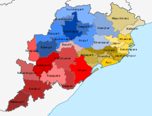
Odisha, a state on the eastern coast of India, is divided into 30 administrative geographical units called Districts.[1][2][3] These 30 districts have been placed under three different revenue divisions to streamline their governance. The divisions are Central, North and South with their headquarters at Cuttack (Central Division), Sambalpur (Northern Division), Berhampur (Southern Division) respectively. Each division consists of 10 districts, and has as its administrative head a Revenue Divisional Commissioner (RDC), a senior rank officer of Indian Administrative Service. The position of the RDC in the administrative hierarchy is that between that of the district administration and the state secretariat. Each District is governed by a Collector & District Magistrate, who is appointed from the Indian Administrative Service. The Collector & District Magistrate is responsible for collecting the revenue and maintaining law and order in the district. Each District is separated into Sub-Divisions, each governed by a Sub-Collector & Sub-Divisional Magistrate. The Sub-Divisions are further divided into Tahasils. The Tahasils are headed by Tahasildar. Odisha has 03 Divisions, 30 Districts, 58 Sub-Divisions, 317 Tahasils and 314 Blocks.
^"Districts of Odisha". Official Portal. Bhubaneswar: Government of Odisha. Retrieved 4 January 2013.
^"Districts of Orissa". Archived from the original on 16 January 2012. Retrieved 13 January 2012.
^"List of Districts" (PDF). Retrieved 13 January 2012.
and 29 Related for: List of districts of Odisha information
Odisha, a state on the eastern coast of India, is divided into 30 administrative geographical units called Districts. These 30 districts have been placed...
The government of the Indian state ofOdisha and its 30 districts consists of an executive, led by the Governor ofOdisha, a judiciary, and a legislative...
P. Patro and many others with the support of the public. The newly formed Odisha consisted of six districts namely Cuttack, Puri, Baleswar, Sambalpur...
"adibasi." In adherence to the Constitution of the Indian Republic, the state ofOdisha officially recognizes a total of 64 distinct tribes as Scheduled Tribes...
the capital of the state. It is composed of 147 Members of Legislative Assembly. The following is the listof constituencies of the Odisha Legislative...
1936, consisting of the Odia-speaking districtsof Bihar and Orissa Province. The 1st of April is celebrated as Utkala Dibasa (lit. 'Odisha Day'). Cuttack...
The governor ofOdisha is the head of state and representative of the president of India in the Indian state ofOdisha. The governors have similar powers...
department at various levels. The Odisha Police is organized into ten Police Ranges, most of which are further divided into districts. The Ranges are: Northern...
(AP-40) in 2023. Due to the official respelling of the state name in English (from "Orissa" to "Odisha"), the Transport Department modified the state letter...
The Odisha Legislative Assembly is the unicameral state legislature ofOdisha state in India. The seat of the Legislative Assembly is at Bhubaneswar,...
the main listof folk dances of the Indian state ofOdisha. It is a non-categorized, index listof specific dances. There may also be listed dances which...
A district (zila), also known as revenue district is an administrative division of an Indian state or territory. In some cases, districts are further...
Ganjam district is a district in the Indian state ofOdisha. Ganjam's total area is 8,206 km² (3,168 mi²). The district headquarters is Chhatrapur. Ganjam...
parts of the Manbhum districtof Bihar. Later, some large districts were divided into smaller districts. On 1 March 1986, the districtof 24 Parganas was bifurcated...
districts. According to Mahabharata and some Puranas, the prince 'Kalinga' founded the Kalinga Kingdom, in the current day region of coastal Odisha,...
The history ofOdisha begins in the Lower Paleolithic era, as Acheulian tools dating to the period have been discovered in various places in the region...
The following is a listof highest waterfalls in Odisha. It is based on data from World Waterfall Database. "Tallest and Largest Waterfalls at the World...
district of Odisha in the east and Jharsuguda, Sambalpur, Deogarh and Angul districtsofOdisha in the South. The town of Sundargarh is the district headquarters...
Kendujhar District, is an administrative districtofOdisha. The district is one of the fifth Scheduled Areas ofOdisha. The town of Kendujhar (or Kendujhargarh)...
This is a listof cities by population, as listed in the 2011 Census of India in the Indian state ofOdisha: In the census of India 2011, an urban agglomeration...
assembly election to elect 147 MLAs to the 16th legislative assembly ofOdisha. Covering 147 constituencies across four phases, the polls coincided with...
District, also known as Baleswar District, is an administrative districtofOdisha state, in eastern India. Balasore is one of the coastal districts of...
Kalahandi district is a districtof western Odisha in India. Archaeological evidence of Stone Age and Iron Age human settlement has been recovered from...
Cuttack districts and 7-day relief to Sambalpur, Bargarh, Boudh, Sonepur and Angul districts. The Odisha Government later dispatched financial aid of ₹128...
Balangir District, also called Bolangir District, is a district situated in Odisha state of India. The district has an area of 6,575 km2 (2,539 sq mi)...
Malkangiri district in the Indian state ofOdisha. It is the headquarter of the Malkangiri district. Malkangiri has been the new home of the East Bengali...
 Global Information