The Himalayas lies in the north of West Bengal and the Bay of Bengal is at the south. Between them, the river Ganga flows eastwards and its main distributary, the Hooghly River, flows south to reach the Bay of Bengal. The Siliguri Corridor, which connects North-East India with rest of the India, lies in the North Bengal region of the state. Geographically, West Bengal is divided into a variety of regions—Darjeeling Himalayan hill region, Terai and Dooars region, North Bengal plains, Rarh region, Western plateau and high lands, coastal plains, Sundarbans and the Ganga Delta.[1]
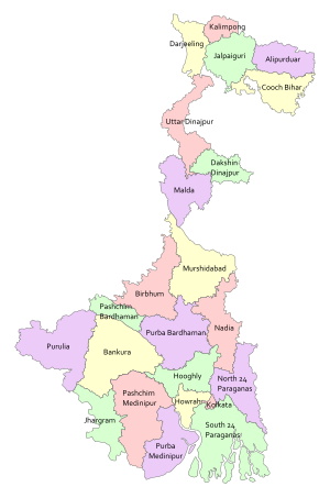
In 1947, when India gained independence, the state of West Bengal was formed, with 14 districts, as per partition plan of the then Bengal province of British India.[2][3] The former princely state Koch Bihar joined as a district on 26 January 1950,[4] and the former French enclave Chandannagore joined as part of the Hooghly district in 1954.[5] The States Reorganisation Act of 1956 led to addition of Purulia district to the state and to enlargement of West Dinajpur district.[6] Later, larger districts such as West Dinajpur, 24 Parganas and Midnapore were bifurcated.
West Bengal is now divided into 23 districts which includes the newly formed Alipurduar district (formed on 25 June 2014), Kalimpong district (formed on 14 February 2017), Jhargram district (formed on 4 April 2017), and the splitting of the former Bardhaman district into Purba Bardhaman district and Paschim Bardhaman district (formed on 7 April 2017). The districts are grouped into five divisions.[7][8]
Divisions are administered by Divisional Commissioners.[9] Kolkata, the capital of the state, constitutes the Kolkata district. Other districts are further divided into administrative units such as subdivisions and blocks, administered by SDO and BDO, respectively. The Panchayati Raj has a three-tier structure in the state. The atomic unit is called a Gram Panchayat, which is the Panchayat organisation for a collection of villages.[10] The block-level organisations are called Panchayat Samiti,[11] and the district-level organisations are named Zilla Parishad.[12]
The West Bengal cabinet has approved the creation of seven new districts on 1 August 2022. This will number district from 23 to 30.[13] New Sundarban District from existing South 24 Parganas District, new Ichhamati District and Basirhat District from existing North 24 Parganas District. New Ranaghat District from existing Nadia District and Bishnupur District from existing Bankura district. While new Jangipur District and Berhampore district from existing Murshidabad District will be carved out.
^Cite error: The named reference swhydro was invoked but never defined (see the help page).
^Cite error: The named reference parttionbanglaped was invoked but never defined (see the help page).
^Cite error: The named reference partitionspoil was invoked but never defined (see the help page).
^Cite error: The named reference CBE was invoked but never defined (see the help page).
^Cite error: The named reference Chander was invoked but never defined (see the help page).
^Cite error: The named reference PF was invoked but never defined (see the help page).
^"The Statesman: Alipurduar to become Bengal's 20th dist". Archived from the original on 14 July 2014. Retrieved 21 June 2014.
^"Roy Alipurduar: Alipurduar a new district on June 25 | Kolkata News – Times of India". The Times of India.
^Cite error: The named reference blocdir was invoked but never defined (see the help page).
^Cite error: The named reference gpdef was invoked but never defined (see the help page).
^Cite error: The named reference psdef was invoked but never defined (see the help page).
^Cite error: The named reference zpdef was invoked but never defined (see the help page).
^"Explained: 7 new districts in West Bengal — how and why are districts created or abolished in India?". The Indian Express. 1 August 2022. Retrieved 2 August 2022.
and 28 Related for: List of districts of West Bengal information
gained independence, the state ofWestBengal was formed, with 14 districts, as per partition plan of the then Bengal province of British India. The former...
division A group ofdistricts forms a division, which is administered by a 'Divisional Commissioner'. WestBengal is now divided in 23 districts, grouped under...
This is a list page of the mountains and hills found in the Indian state ofWestBengal. It includes a listof the highest mountains in each of the constituent...
is a listofdistricts in the Indian state ofWestBengal ranked by literacy rate as per provisional data of 2011 census. With a literacy rate of 96.26%...
below district level and above the block or Tehsil level in the state WestBengalof India. Presently there are 69 subdivisions in 23 districtsofWest Bengal...
city of Kolkata) which comprises one of the two general police districtsofWestBengal under the Police Act 1861. The other general police district consists...
WestBengal (/bɛnˈɡɔːl/, Bengali: Poshchim Bongo, pronounced [ˈpoʃtʃim ˈbɔŋɡo] , abbr. WB) is a state in the eastern portion of India. It is situated...
The WestBengal Legislative Assembly is the unicameral legislature of the Indian state ofWestBengal. It is located in the B. B. D. Bagh area of Kolkata...
The Governor ofWestBengal is the nominal head of the Indian state ofWestBengal and a representative of the President of India. The governor is appointed...
ofWestBengal is the site of India's first modern university and 33 universities are listed under the University Grants Commission (India). In West Bengal...
Hooghly district (/ˈhuːɡliː/) is one of the districtsof the Indian state ofWestBengal. It can alternatively be spelt Hoogli or Hugli. The district is named...
The Geography ofWestBengal, a state in eastern India, is primarily defined by plains and plateaus, with the high peaks of the Himalayas in the north...
Government ofWestBengal (Bengali: পশ্চিমবঙ্গ সরকার), also known as the WestBengal Government, is the principal administrative authority of the Indian...
style ofBengal patachitra in the districtsofWestBengal in his book Folk Art ofBengal. The patachitra of different districtsofWestBengal are characterized...
Darjeeling District is the northernmost districtof the state ofWestBengal in eastern India in the foothills of the Himalayas. The district is famous...
Howrah district (/ˈhaʊrə/, Bengali: [ˈɦao̯ɽa]) is a districtof the WestBengal state in eastern India. Howrah district is one of the highly urbanized...
held in 2016 for the 294 seats (out of 295 seats) of the Vidhan Sabha (Vidhān Sabhā) in the state ofWestBengal in India. The All India Trinamool Congress...
[nɔd̪iːaː]) is a district in the state ofWestBengal, India. It borders Bangladesh to the east, North 24 Parganas and Hooghly districts to the south, Purba...
population above 100,000 as per the 2011 census in the Indian state ofWestBengal. In the census of India 2011, an urban agglomeration has been defined as follows:...
administrative or revenue districts in Delhi, India, all of which fall under the Delhi division. Each of these district is headed by a District Magistrate (DM)...
The music ofWestBengal includes multiple indigenous musical genres such as Baul, Ramprasadi, Bishnupuri Classical, Kirtan, Shyama Sangeet, Rabindra Sangeet...
2011 census, WestBengal has over 24.6 million Muslims, making up 27% of the state's population. The vast majority of Muslims in WestBengal are ethnic...
Dinajpur, is a districtof the Indian state ofWestBengal. Created on 1 April 1992 by the division of the erstwhile West Dinajpur district, it comprises...
history ofWestBengal basically refers to the history of the western part ofBengal, located in the eastern part of the Indian subcontinent. Evidence of human...
Politics in WestBengal is dominated by the following major political parties: the All India Trinamool Congress, the Communist Party of India (Marxist)...
 Global Information