List of Grand Canyon rapids and features information
The following is a list of major rapids and other notable features on the Colorado River through Marble Canyon and Grand Canyon below Glen Canyon Dam, in order of their position downstream of Lee's Ferry. Ratings are given for how difficult the rapid is to navigate by whitewater raft or other water craft. The Grand Canyon section of the Colorado River, like several other big-water Western rivers, uses a rapids scale developed by Otis R. Marston of 1–10 for rapids, 10 being the most difficult. The International Scale of River Difficulty, which classifies rapids from class I to VI, is more common elsewhere in the US and internationally.
Mile 0.0 – Lee's Ferry A large raft is launched at Lee's Ferry (Mile 0.0)
Mile 8.0 – Badger Creek Rapid (5) – First significant rapid in Marble Canyon with a large pour over in the center right.
Mile 11.4 – Soap Creek Rapid (5)
Mile 12.1 – Brown's Riffle (2) On July 9, 1889, the President of the Denver, Colorado Canyon and Pacific Railroad, Frank Mason Brown, drowned at this point when the boat he was in capsized. He was not wearing a life jacket.[1]
Mile 14.5 – Sheer Wall Rapid (2)
Mile 17.1 – House Rock Rapid (7) – The first major rapid in Marble Canyon. A large hole on the left side of the river forms at most water levels, necessitating a right run.
Mile 17.7 – Redneck Rapid (3)
Mile 20.7 – North Canyon Rapid (5) (beginning of the "Roaring 20's")
Mile 21.4 – 21 Mile Rapid (5)
Mile 23.2 – 23 Mile Rapid (4) A sharp lateral on the right has flipped many a raft here.
Mile 23.5 – 23.5 Mile Rapid (4)
Mile 24.4 – 24 Mile (Georgie) Rapid (6)
Mile 24.7 – 24.5 Mile Rapid (6) On July 8, 1949, 79-year-old Albert "Bert" Loper had a heart attack and died in this rapid while rowing his boat Grand Canyon.[2]
Mile 25.1 – 25 Mile (Hansbrough-Richards) Rapid (6) This rapid is named for two more men of the Brown Stanton expedition, Peter Hansbrough and Henry Richards, also not wearing life jackets, who drowned at this rapid on Monday, July 15, 1889.[3]
Mile 33.2 – No rapid – site of the proposed Redwall Dam
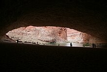
Mile 33.3 – Redwall Cavern – A very large alcove in the Redwall Sandstone at river level. Very popular stop for river trips. Redwall Cavern (Mile 33.3)
Mile 35.0 – Nautiloid Canyon
Mile 36.0 – The Bridge of Sighs; this is one of the few Grand Canyon arches visible from the river.
Mile 36.3 – 36 Mile Rapid (4)
Mile 39.7 – No rapid – site of the proposed Marble Canyon Damsite.
Mile 43.3 – Anasazi Bridge
Mile 44.0 – President Harding Rapid (4) – The river splits around a large rock in the middle of the river.
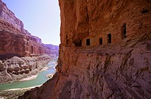
Mile 52.4 – Nankoweap Rapid (3) Ancestral Puebloan granaries at Nankoweap Creek (Mile 52.4)
There are three popular campsites at Nankoweap for river trips. A steep trail up a nearby talus slope leads to Ancestral Puebloan granaries. This is also where the Nankoweap Trail reaches the river.
Mile 56.3 – Kwagunt Rapid (5)
Mile 60.1 – 60 Mile Rapid (4)
Mile 61.7 – Little Colorado River Confluence.
Mile 65.1 – Carbon Creek
Mile 65.9 – Lava Canyon (Chuar) Rapid (4)
Mile 69.0 – Tanner Rapid (6), terminus of the Tanner Trail and the Tanner Graben
Outfall of Tanner Creek, then the (black) Tanner Graben, then Basalt Creek with Basalt Rapid (Mile 69.9)
Mile 69.9 – Basalt Rapid (6) This rapid has a sharp pour-over on the left at low water.
Mile 72.9 – Unkar Rapid (6) The Colorado River near Unkar Rapid (Mile 72.9)
Mile 73.6 – 73.6 Mile Riffle (4) This rapid has some exposed boulders on the left.
Mile 75.3 – Escalante Creek Rapid (4)
Mile 75.8 – 75 Mile (Nevills) Rapid (4)
Mile 77.1 – Hance Rapid (8) – Multiple large rocks constrict the channel and form powerful hydraulics; terminus of the Hance Trail.
Mile 79.1 – Sockdolager Rapid (7) – (Sockdolager is an archaic slang word for knockout blow.)
Mile 82.1 – Grapevine Rapid (7)
Mile 84.1 – 83 Mile Rapid (4)
Mile 85.3 – Zoroaster Rapid (5)
Mile 85.8 – 85 Mile Rapid (3)
Mile 88.1 – Black Suspension Bridge (Kaibab Bridge) and Phantom Ranch boat beach, where the South Kaibab Trail crosses the river
Mile 88.3 – Bright Angel Rapid (3), Bright Angel Creek and Bright Angel Bridge, where the River Trail begins
Mile 89.5 – Pipe Creek Rapid (3), where the River Trail ends and continues towards the South Rim as the Bright Angel Trail
Mile 90.8 – Horn Creek Rapid (8) – At lower water, forms very large waves and hydraulics and is one of the most difficult rapids in the canyon requiring a right to left downstream pull to miss a rock ledge on river right.
Mile 93.1 – Salt Creek Rapid (3)
Mile 93.9 – Granite Rapid (8) – One of the more difficult rapids with a strong push of hydraulics to the wall on river right.
Mile 95.5 – Hermit Rapid (8) – Perhaps the strongest hydraulics and biggest waves in the canyon; terminus of the Hermit Trail
Motorized raft in Hermit Rapid (Mile 95.5)
Mile 97.1 – Boucher Rapid (4)
Mile 98.2 – Crystal Rapid (8) – [1] Several very large holes followed by a dangerous rock garden at bottom of rapids in mid channel. Formed in 1966 when a flash flood of Crystal Canyon washed debris into the river. The beginning of a series of rapids called "the gems."
Mile 179.7 – Lava Falls Rapid (9) – Also known as Vulcan Rapid, is perhaps the most difficult, if short, run in the entire canyon. It is on the east edge of the Uinkaret volcanic field.[4]
Mile 180.1 – Lower Lava Rapid (4)
Mile 186.0 – 185 Mile Rapid (2)
Mile 187.4 – Whitmore Helipad is where most concessions passengers end their trip by helicopter take-out.
Mile 188.3 – Whitmore Rapid (3)
Mile 205.6 – 205 Mile (Kolb) Rapid (6)
Mile 209.2 – 209 Mile Rapid (5) This rapid has a large hole in the middle of the rapid.
Mile 212.5 – Little Bastard (LB) Rapid (3)
Mile 213.3 – Pumpkin Spring
Mile 216.0 – Three Springs Rapid (2)
Mile 217.8 – 217 Mile Rapid (5)
Mile 219.6 – Trail Canyon (Ducky Eater) Rapid (2) Cross-river hydraulics can flip small inflatable kayaks here.
Mile 220.7 – Granite Spring Rapid (2)
Mile 223.7 – 224 Mile Rapid (3)
Mile 225.9 – Diamond Creek Take-out/Put-in. This is the first location downriver from Lee's Ferry where a road reaches the Colorado River. The road is prone to flash flood by Diamond Creek in monsoon season. This is the only takeout for Grand Canyon boating trips above Lake Mead when the lake is high, however, recently the lake has been lower, allowing the Colorado River to flow all the way past the take out at Pearce Ferry, Lake Mead.
Mile 225.9 – Diamond Creek Rapid (4)
Mile 228.2 – 228.2 Mile Rapid (3)
Mile 229.3 – Travertine Rapid (2)
Mile 231.2 – 231 Mile Rapid (5)
Mile 232.5 – 232 Mile (Killer Fang Falls) Rapid (4–7) – Bessie Hyde of the 1928 Disappearance of Glen and Bessie Hyde wrote in her journal up to this rapid. Her journal was located in her abandoned sweep scow below this rapid. 18 foot long raft flips at Killer Fang Falls (Mile 232.3)[5]
Mile 233.9 – 234 Mile Rapid (5)
Mile 235.3 – Bridge Canyon Rapid (4)
Mile 236.0 – Gneiss Canyon Rapid (5)
Mile 239.5 – Separation Rapid (1)
Mile 280.5 – Pearce Ferry Take-out at Pearce Ferry, Lake Mead, is the first take-out point for river trips traveling through the entire Grand Canyon. This Take-Out (on Lake Mead) has been recently renovated, making it operational at low reservoir levels. With the appearance of Pearce Ferry Rapid, this take-out has become preferred, as the rapid just below is often considered unrunnable, though this is always changing.
Mile 280.8 – Pearce Ferry Rapid (unrunnable; class VI on the International Scale of River Difficulty) This rapid was created in 2007 when the level of Lake Mead went below 1138 feet. Lake Mead was over 70 feet deep here in 2000. This rapid is formed by the Colorado River running full force into a hillside. It is a must-scout for any river runners continuing to the next take-out on Lake Mead at South Cove. It is currently considered to be unrunnable.[6]
Mile 297 – South Cove Take-Out (in Lake Mead)
^Marston, Otis R., (2014). "From Powell To Power; A Recounting of the First One Hundred River Runners Through the Grand Canyon. Flagstaff, Arizona: Vishnu Temple Press, p. 130 ISBN 978-0990527022
^Marston, Otis R., (2014). "From Powell To Power; A Recounting of the First One Hundred River Runners Through the Grand Canyon. Flagstaff, Arizona: Vishnu Temple Press, p. 454 ISBN 978-0990527022
^Marston, Otis R., (2014). "From Powell To Power; A Recounting of the First One Hundred River Runners Through the Grand Canyon. Flagstaff, Arizona: Vishnu Temple Press, p. 132 ISBN 978-0990527022
^Marston, Otis R., (2014). "From Powell To Power; A Recounting of the First One Hundred River Runners Through the Grand Canyon. Flagstaff, Arizona: Vishnu Temple Press, p. 182 ISBN 978-0990527022
^Marston, Otis R., (2014). "From Powell To Power; A Recounting of the First One Hundred River Runners Through the Grand Canyon. Flagstaff, Arizona: Vishnu Temple Press, p. 325 ISBN 978-0990527022
^Lucas, Joel (February 10, 2016). "The Drought Has Created New Gnarly Rapids in the Grand Canyon". Outside. Retrieved November 26, 2016.
and 27 Related for: List of Grand Canyon rapids and features information
Canyon extends into northern Arizona and terminates at Lee's Ferry, near the Vermilion Cliffs. Like the GrandCanyon farther downstream, Glen Canyon is...
their exploits running the rapidsof the Colorado River. Buzz Holmstrom made a solo trip through Cataract CanyonandGrandCanyon in 1937, eventually ending...
Widforss Trail Arizona portal GrandCanyonGrandCanyon National Park Listof Colorado River rapidsandfeatures "GrandCanyon National Park Backcountry Hiking"...
across the bottom of the canyon, in sharp contrast to the roaring rapids upstream in Cataract Canyonand downstream in the GrandCanyon. After his groundbreaking...
northeasternmost reaches ofGrandCanyon National Park on the southwest, and the Navajo Nation on the southeast. The southwestern end of Glen Canyon NRA in Arizona...
park's central feature is the GrandCanyon, a gorge of the Colorado River, which is often considered one of the Wonders of the World. The park, which covers...
Desolation Canyon is a remote canyon on the Green River in eastern Utah, United States that is listed on the National Register of Historic Places (NRHP)...
a listof natural features on the Fraser River, including canyons, rapids, bars, named rocks and eddies and similar features. Important side canyons which...
Delta at the tip of the Gulf of California between Baja California and Sonora. Known for its dramatic canyons, whitewater rapids, and eleven U.S. National...
Colorado Plateau country of western Colorado, southeastern Utah and northwestern Arizona where it flows through the GrandCanyon. It turns south near Las...
the river from Lake Tana to the end of the canyon; subsequent river rafting parties called it the "GrandCanyonof the Nile". The Blue Nile Falls (Amharic:...
Below the Confluence, Cataract Canyon contains powerful whitewater rapids, similar to those found in the GrandCanyon. However, since there is no large...
Site projects, being shelved in favour of Site C. The Liard Canyon is a separate canyon from the GrandCanyon, and is located near Lower Post. 59°59′00″N...
in rapids), and drowning. Listof trails in GrandCanyon National Park Geology of the GrandCanyon area GrandCanyon National Park, Overnight Use of Trans-canyon...
River Hassayampa River Hardy River Gulf of California-(Sea of Cortez) GrandCanyonRapidsandFeatures River and Tributary Locations determined by examining...
and launch ramp, and about 55 miles (89 km) of the Colorado River within the lower GrandCanyon, extending to the foot of 240 Mile Rapids (north of Peach...
partially in GrandRapids, Michigan, the author's home town, and was inspired in part by Van Allsburg's memories of visiting the Herpolsheimer's and Wurzburg's...
located in GrandCanyon National Park in the U.S. state of Arizona. The trail originates at GrandCanyon Village on the south rim of the GrandCanyon, descending...
camping, andrapids for inflatables and kayaks. The section from Slickrock to Bedrock, Colorado goes through the goosenecks of a sandstone canyon with several...
valley directly downstream from Glen Canyonand shortly above Marble Canyon (the uppermost section of the GrandCanyon), it is the only place in more than...
boulders in rapids), and drowning. Listof trails in GrandCanyon National Park GrandCanyon National Park, Overnight Use of Trans-canyon Corridor Trails...
the city ofGrand Junction, Colorado. Sheer-walled canyons cut deep into sandstone and granite–gneiss–schist rock formations. This is an area of desert...
in terms of volume of water, depth and surface area.[citation needed] Lake Powell was created by the flooding of Glen Canyon by the Glen Canyon Dam, which...
east of the GrandCanyon Village, and the trail ends at the Colorado River at Tanner Rapids. The Tanner Trail started out as an ancient Anasazi and Hopi...
a listof water parks in the Americas sorted by region. Aquaventure, Nassau (part of Atlantis Paradise Island) Baha Bay Water Park (part ofGrand Hyatt...
 Global Information