 Global Information
Colorado River information
| Colorado River | |
|---|---|
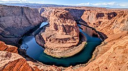 The Colorado River at Horseshoe Bend, Arizona, a few miles below Glen Canyon Dam | |
 Map of the Colorado River basin | |
| Location | |
| Country | United States, Mexico |
| States | |
| Cities | Glenwood Springs, CO, Grand Junction, CO, Moab, UT, Page, AZ, Bullhead City, AZ, Lake Havasu City, AZ, Blythe, CA, Yuma, AZ, Las Vegas, NV, Laughlin, NV, San Luis Río Colorado, Son. |
| Physical characteristics | |
| Source | La Poudre Pass |
| • location | Rocky Mountains, Colorado, United States |
| • coordinates | 40°28′20″N 105°49′34″W / 40.47222°N 105.82611°W[1] |
| • elevation | 10,184 ft (3,104 m) |
| Mouth | Gulf of California |
• location | Colorado River Delta, Baja California–Sonora, Mexico |
• coordinates | 31°48′54″N 114°48′00″W / 31.81500°N 114.80000°W |
• elevation | 0 ft (0 m) |
| Length | 1,450 mi (2,330 km)[2] |
| Basin size | 246,000 sq mi (640,000 km2)[2] |
| Discharge | |
| • location | mouth (average unimpaired flow), max and min at Topock, AZ, 300 mi (480 km) from the mouth[3] |
| • average | 22,500 cu ft/s (640 m3/s)[3] |
| • minimum | 422 cu ft/s (11.9 m3/s)[4] |
| • maximum | 384,000 cu ft/s (10,900 m3/s)[5] |
| Basin features | |
| Tributaries | |
| • left | Fraser River, Blue River, Eagle River, Roaring Fork River, Gunnison River, Dolores River, San Juan River, Little Colorado River, Bill Williams River, Gila River |
| • right | Green River, Dirty Devil River, Escalante River, Kanab River, Virgin River, Hardy River |
The Colorado River (Spanish: Río Colorado) is one of the principal rivers (along with the Rio Grande) in the Southwestern United States and in northern Mexico. The 1,450-mile-long (2,330 km) river, the 5th longest in the United States, drains an expansive, arid watershed that encompasses parts of seven U.S. states and two Mexican states. The name Colorado derives from the Spanish language for "colored reddish" due to its heavy silt load. Starting in the central Rocky Mountains of Colorado, it flows generally southwest across the Colorado Plateau and through the Grand Canyon before reaching Lake Mead on the Arizona–Nevada border, where it turns south toward the international border. After entering Mexico, the Colorado approaches the mostly dry Colorado River Delta at the tip of the Gulf of California between Baja California and Sonora.
Known for its dramatic canyons, whitewater rapids, and eleven U.S. National Parks, the Colorado River and its tributaries are a vital source of water for 40 million people.[6] An extensive system of dams, reservoirs, and aqueducts divert almost its entire flow for agricultural irrigation and urban water supply.[7][8][9] Its large flow and steep gradient are used to generate hydroelectricity, meeting peaking power demands in much of the Intermountain West. Intensive water consumption has dried up the lower 100 miles (160 km) of the river, which has rarely reached the sea since the 1960s.[7][10][11]
Native Americans have inhabited the Colorado River basin for at least 8,000 years. Starting around 1 CE, large agriculture-based societies were established, but a combination of drought and poor land use practices led to their collapse in the 1300s. Their descendants include tribes such as the Puebloans, while others including the Navajo settled in the Colorado Basin after the 1000s. In the 1500s, Spanish explorers began mapping and claiming the watershed, which became part of Mexico upon winning its independence from Spain in 1821. Even after most of the watershed became US territory in 1846, much of the river's course remained unknown. Several expeditions charted the Colorado in the mid-19th century—one of which, led by John Wesley Powell, was the first to run the rapids of the Grand Canyon. Large-scale settlement of the lower basin began in the mid- to late-1800s, with steamboats sailing from the Gulf of California to landings along the river that linked to wagon roads to the interior. Starting in the 1860s, gold and silver strikes drew prospectors to the upper Colorado River basin.
Large-scale river management began in the early 1900s, with major guidelines established in a series of international and US interstate treaties known as the "Law of the River". The US federal government constructed most of the major dams and aqueducts between 1910 and 1970; the largest, Hoover Dam, was completed in 1935. Numerous water projects have also involved state and local governments. With all of their waters fully allocated, both the Colorado and the neighboring Rio Grande are now considered among the most controlled and litigated river systems in the world. Since 2000, extended drought has conflicted with increasing demands for Colorado River water, and the level of human development and control of the river continues to generate controversy.
- ^ "Colorado River". Geographic Names Information System. United States Geological Survey, United States Department of the Interior. February 8, 1980. Retrieved February 18, 2012.
- ^ a b Cite error: The named reference
USGSriverswas invoked but never defined (see the help page). - ^ a b Nowak, Kenneth C. (April 2, 2012). "Stochastic Streamflow Simulation at Interdecadal Time Scales and Implications to Water Resources Management in the Colorado River Basin" (PDF). Center for Advanced Decision Support for Water and Environmental Systems. University of Colorado. p. 114. Archived from the original (PDF) on May 1, 2014. Retrieved July 11, 2013.
- ^ "USGS Gage #09424000 on the Colorado River near Topock, AZ – Daily Data". National Water Information System. U.S. Geological Survey. February 14, 1935. Archived from the original on August 6, 2020. Retrieved April 21, 2012.
- ^ Wiltshire, Gilbert & Rogers 2010, p. 102.
- ^ "The Compact and Lees Ferry". Colorado River Streamflow: A Paleo Perspective. Western Water Assessment. Archived from the original on April 29, 2012.
- ^ a b Waterman, Jonathan (February 15, 2012). "Where the Colorado Runs Dry". The New York Times. Archived from the original on August 21, 2021. Retrieved October 14, 2014.
- ^ Cite error: The named reference
ImperialEBwas invoked but never defined (see the help page). - ^ "San Juan – Chama Project". Archived from the original on August 23, 2021. Retrieved August 23, 2021.
- ^ Diaz, Henry F.; Anderson, Craig A. (November 28, 2003). "Precipitation Trends and Water Consumption in the Southwestern United States". Impact of Climate Change and Land Use in the Southwestern United States. U.S. Geological Survey. Archived from the original on March 9, 2012.
- ^ Postel, Sandra (May 19, 2014). "A Sacred Reunion: The Colorado River Returns to the Sea". National Geographic. Archived from the original on January 8, 2018. Retrieved May 19, 2021.