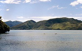
Lake Rotoaira (sometimes written Lake Roto-aira) is a small lake to the south of Lake Taupō on the North Island Volcanic Plateau in New Zealand. It covers an area of 13 km2.
Lake Rotoaira is one of the few privately owned lakes in New Zealand being administered by the Lake Rotoaira Trust on behalf of its owners. An access permit must be held by those using the lake for fishing and similar activities.
The lake is located in a graben between the broad volcanic dome of Mount Tongariro to the south and the smaller volcanic peak of Pihanga to the northwest. It is naturally drained by the Poutu Stream into the Tongariro River.
The Tongariro Power Scheme utilises Rotoaira as a storage lake for the Tokaanu Power Station.[1][2] Extensive engineering works were carried out between 1964 and 1971 diverting a number of streams (including Whanganui River) into Rotoaira via Lake Otamangakau and construction of a tunnel through Pihanga to the Tokaanu Power Station.[3] The lake originally drained into the Poutu Stream but when the Poutu Dam was constructed the lake level was raised by about 50 cm.[4] Motuopuhi Island was formerly a peninsula but became an island when the water level was raised by the Tongariro power scheme.[5] Motuopihi was the hiding place of Te Rauparaha and where he composed the Ka Mate haka.[5]
Opōtaka, a traditional site of Māori occupation, is situated on the northern shore of the lake. Of significance to iwi Ngāti Tūwharetoa and Ngāti Hikairo it was excavated during archaeological investigations on the Tongariro Power Scheme and was found to have been occupied in the 19th century.[6][7] In 2022 Ngāti Hikairo received funding to restore Opōtaka.[8]
In 2021 the Lake Rotoaira Forest Trust received funding from the government's Jobs for Nature programme to remove invasive plants and animals from around the lake, particularly in the lake's wetlands.[9]
^McKinnon, Malcolm (2015). "Volcanic Plateau places - Tongariro area". Te Ara. Retrieved 31 October 2023.
^"Tongariro Power Scheme | Genesis NZ". www.genesisenergy.co.nz. Retrieved 2023-10-26.
^Martin, John E., ed. (1998). People, politics and power stations: electric power generation in New Zealand 1880-1998. Wellington, NZ: Electricity Corporation of New Zealand. pp. 220–234. ISBN 978-0-908912-98-8. OCLC 931064862.
^Lake Managers' Handbook: Fish in New Zealand Lakes(PDF). Wellington: Ministry for the Environment. 2002. ISBN 0-478-24069-4.
^ ab"Motuopihi Island". Te Ara - the Encyclopedia of New Zealand. 2017. Retrieved 31 October 2023.
^"An introduction to Opotaka". Heritage New Zealand visitheritage.co.nz. Retrieved 2023-10-31.
^Walton, Anthony (July 1994). "Settlement at Opotaka". New Zealand Historic Places. 48: 39–41. ISSN 0114-9172.
^Ellis, Moana (2022-03-23). "Historic site restoration a boost for tribe's emotional connection to the land". Stuff. Retrieved 2023-12-02.
^"Tackling Tongariro's biodiversity threats". beehive.govt.nz. 15 November 2021. Retrieved 15 November 2023.
LakeRotoaira (sometimes written Lake Roto-aira) is a small lake to the south of Lake Taupō on the North Island Volcanic Plateau in New Zealand. It covers...
into LakeRotoaira, joining water from the Eastern Diversion. LakeRotoaira is kept at a raised level by the Poutu Dam. Water stored in LakeRotoaira from...
and Waikato enemies. He had hidden from them, on Motuopihi Island in LakeRotoaira, in a kūmara storage pit while a woman (wāhine) by the name of Rangikoaea...
Tongariro and Lake Taupō. The nearest town to Pihanga is Turangi. LakeRotoaira lies to the south-west of Pihanga, and the smaller Lake Rotopounamu is...
Waihohonu Stream, down to Lake Taupō, it has been formally named the Tongariro River since 1945. The Poutu Stream joins from LakeRotoaira to the east, as a tributary...
shore of LakeRotoaira. Okahukura Bush lies to the south, at the north end of the Tongariro Crossing. Otūkou Marae, located west of the lake, is a meeting...
Papakai and Otukou are not part of the park but lie on the shores of LakeRotoaira between the Pihanga Scenic Reserve and the main park area. The bulk...
northeast of Ohakune and 23 km (14 mi) southwest of the southern shore of Lake Taupō, within the Tongariro National Park. The North Island's major ski resorts...
over 3 m (9.8 ft) in diameter), Te Whaiau Stream and Lake Otamangakau reservoir to LakeRotoaira, as part of the Tongariro Power Scheme, built between...
Te Rauparaha composed "Ka Mate" while hiding on Motuopihi Island in LakeRotoaira as a celebration of life over death after his lucky escape from pursuing...
metres: Lake Hauroko: 462 and ~117. Lake Manapouri: 444 and 149. Lake Te Anau: 425 and ~169. Lake Wakatipu: 420 and 130. Lake Hāwea: 392 and ~101. Lake Wānaka:...
and Ngāti Apa from the region around Lake Taupō, New Zealand. Te Rehu was born at Orangi-te-taea on LakeRotoaira. His father was Matangikaiawha, a descendent...
SH 41 (Tokaanu Road) – Taumarunui, National Park Rangipo 763 474 SH 46 (LakeRotoaira Road) – National Park Desert Road begins Ruapehu District Desert Road...
North Island of New Zealand. It is located 20 km (12 mi) to the southwest of Lake Taupō, and is the northernmost of the three active volcanoes that dominate...
the urupā at his family kāinga (settlement), Otukou, on the shores of LakeRotoaira. Catholic Hierarchy website, Bishop Max Takuira Matthew Mariu SM "Heart...
with LakeRotoaira, which is located southeast of Lake Otamangakau. The waters of Lake Otamangakau flow over the Wairehu Canal to LakeRotoaira, which...
 Global Information