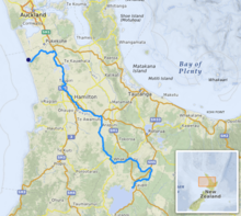
The Waikato River is the longest river in New Zealand, running for 425 kilometres (264 mi) through the North Island. It rises on the eastern slopes of Mount Ruapehu, joining the Tongariro River system and flowing through Lake Taupō, New Zealand's largest lake. It then drains Taupō at the lake's northeastern edge, creates the Huka Falls, and flows northwest through the Waikato Plains. It empties into the Tasman Sea south of Auckland, at Port Waikato. It gives its name to the Waikato region that surrounds the Waikato Plains. The present course of the river was largely formed about 17,000 years ago. Contributing factors were climate warming, forest being reestablished in the river headwaters and the deepening, rather than widening, of the existing river channel. The channel was gradually eroded as far up river as Piarere, leaving the old Hinuera channel through the Hinuera Gap high and dry.[3] The remains of the old course are seen clearly at Hinuera, where the cliffs mark the ancient river edges. The Waikato's main tributary is the Waipā River, which converges with it at Ngāruawāhia.
The name Waikato comes from the Māori language and translates as flowing water.[4][5] The Waikato River has spiritual meaning for various local Māori tribes, including the large Tainui, who regard it as a source of their mana, or pride. The widely respected marae of Tūrangawaewae is close to its banks at Ngāruawāhia.
For many years the Tainui tribe have sought to re-establish their links to the river after the New Zealand Wars (see Invasion of the Waikato) and the subsequent confiscations of the 1860s, and are continuing negotiations with the New Zealand government. The Tainui iwi was advised not to bring a case for the river before the Waitangi Tribunal as they would not win. An out-of-court settlement was arranged and the deed of settlement signed by the Crown and Waikato-Tainui in August 2008 settled the raupatu claim to the Waikato River, although other claims for land blocks and harbours are still outstanding. Waikato-Tainui now have joint management of the river with Waikato Regional Council.
^"Environment". Environment Waikato. Retrieved 28 May 2010.
^NIWA Water & soil miscellaneous publication no. 48 (1983)
^McCraw, John (2011). The Wandering River: Landforms and Geological History of the Hamilton Basin. Guidebook no. 16. Geoscience Society of New Zealand. pp. 36–37.
^"Waikato River". An Encyclopaedia of New Zealand. 1966.
^"The Waikato: A History of New Zealand's Greatest River". Stuff.co.nz.
The WaikatoRiver is the longest river in New Zealand, running for 425 kilometres (264 mi) through the North Island. It rises on the eastern slopes of...
Waikato (/ˈwaɪkɑːtɔː/) is a region of the upper North Island of New Zealand. It covers the Waikato District, Waipa District, Matamata-Piako District, South...
Port Waikato is a New Zealand town that sits on the south bank of the WaikatoRiver, at its outflow into the Tasman Sea, in the northern Waikato. Port...
The Invasion of the Waikato became the largest and most important campaign of the 19th-century New Zealand Wars. Hostilities took place in the North Island...
Benmore) Karihoa Island (in WaikatoRiver) Kaiwaka No.1 Island (in WaikatoRiver delta) Kaiwaka No.2 Island (in WaikatoRiver delta) Lee Island (in Lake...
Mercury generates most of its energy from nine hydro stations on the WaikatoRiver and five geothermal plants in the central north island as well as a...
Waikato Tainui, Waikato or Tainui is a group of Māori iwi based in Waikato Region, in the western central region of New Zealand's North Island. It is part...
and Waikato Tainui peoples, around the 17th century at Waiuku. Waiuku became a trading port in 1851, facilitating trade between the WaikatoRiver and...
landscape and may have caused the WaikatoRiver to shift from the Hauraki Plains to its current course through the Waikato to the Tasman Sea. Less than 22...
Zealand's WaikatoRiver is considered not safe to eat, as caused by pollution in the river. Corbicula is a successful breeder in the rivers and lakes...
waterfalls on the WaikatoRiver, which drains Lake Taupō in New Zealand. A few hundred metres upstream from Huka Falls, the WaikatoRiver narrows from approximately...
Waikato District is a territorial authority of New Zealand, in the northern part of Waikato region, North Island. Waikato District is administered by...
The Waikato Plains (the alternative name Waikato Basin is an ambiguous term as it can refer to the entire river catchment) form a large area of low-lying...
current Waikato Museum building is located at 1 Grantham Street in Hamilton’s central business district on the west bank of the WaikatoRiver. It was...
power station on the WaikatoRiver, in the North Island of New Zealand. It is the sixth hydroelectric power station on the WaikatoRiver. It is the smallest...
especially around the WaikatoRiver mouth region. The earthquake's epicenter is suggested to be close to the mouth of the WaikatoRiver, based on local newspaper...
Power Station—was built for the Waihi gold mines at Horahora on the WaikatoRiver. This set a precedent that was to dominate New Zealand's electricity...
small township on the west bank of the WaikatoRiver in the Waikato District of New Zealand. It is on the Waikato Plains 13 km (8.1 mi) north of Hamilton...
 Global Information