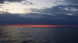
Past sunset at Labrador Sea, off the coast of Paamiut, Greenland
Labrador Sea
Coordinates
61°N56°W / 61°N 56°W / 61; -56 (Labrador Sea)
Type
Sea
Basin countries
Canada and Greenland
Max. length
c. 1,000 km (621 mi)
Max. width
c. 900 km (559 mi)
Surface area
841,000 km2 (324,700 sq mi)
Average depth
1,898 m (6,227 ft)
Max. depth
4,316 m (14,160 ft)
References
[1][2]
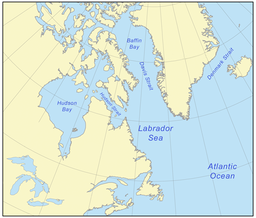
The Labrador Sea (French: mer du Labrador; Danish: Labradorhavet) is an arm of the North Atlantic Ocean between the Labrador Peninsula and Greenland. The sea is flanked by continental shelves to the southwest, northwest, and northeast. It connects to the north with Baffin Bay through the Davis Strait.[3] It is a marginal sea of the Atlantic.[4][5]
The sea formed upon separation of the North American Plate and Greenland Plate that started about 60 million years ago and stopped about 40 million years ago. It contains one of the world's largest turbidity current channel systems, the Northwest Atlantic Mid-Ocean Channel (NAMOC), that runs for thousands of kilometers along the sea bottom toward the Atlantic Ocean.
The Labrador Sea is a major source of the North Atlantic Deep Water, a cold water mass that flows at great depth along the western edge of the North Atlantic, spreading out to form the largest identifiable water mass in the World Ocean.
Map showing the Labrador Sea according to the IHO definition
^"Labrador" (in Russian). Great Soviet Encyclopedia.
^Wilson, R. C. L; London, Geological Society of (2001). "Non-volcanic rifting of continental margins: a comparison of evidence from land and sea". Geological Society, London, Special Publications. 187 (1): 77. Bibcode:2001GSLSP.187...77C. doi:10.1144/GSL.SP.2001.187.01.05. ISBN 978-1-86239-091-1. S2CID 140632779.
^Calow, Peter (12 July 1999). Blackwell's concise encyclopedia of environmental management. Wiley-Blackwell. p. 7. ISBN 978-0-632-04951-6. Retrieved 29 November 2010.
^Spall, Michael A. (2004). "Boundary Currents and Watermass Transformation in Marginal Seas". J. Phys. Oceanogr. 34 (5): 1197–1213. Bibcode:2004JPO....34.1197S. doi:10.1175/1520-0485(2004)034<1197:BCAWTI>2.0.CO;2. S2CID 128436726.
The LabradorSea (French: mer du Labrador; Danish: Labradorhavet) is an arm of the North Atlantic Ocean between the Labrador Peninsula and Greenland. The...
Siberian Sea – 987,000 km2 Lazarev Sea – 929,000 km2 Kara Sea – 926,000 km2 Scotia Sea – 900,000 km2 LabradorSea – 841,000 km2 Andaman Sea – 797,700 km2...
LabradorSea Water is an intermediate water mass characterized by cold water, relatively low salinity compared to other intermediate water masses, and...
Labrador (/ˈlæbrədɔːr/ LAB-rə-dor) is a geographic and cultural region within the Canadian province of Newfoundland and Labrador. It is the primarily continental...
the north, the LabradorSea to the east, and the Gulf of Saint Lawrence to the southeast. The peninsula includes the region of Labrador, which is part...
The Labrador Current is a cold current in the North Atlantic Ocean which flows from the Arctic Ocean south along the coast of Labrador and passes around...
System is a major North American geological structure extending from the LabradorSea in the southeast through Davis Strait, Baffin Bay and the Arctic Archipelago...
formation of sea ice). Unlike the AMOC, the observations of LabradorSea outflow showed no negative trend from 1997 to 2009, and the LabradorSea convection...
The Philippine Sea is a marginal sea of the Western Pacific Ocean east of the Philippine Archipelago (hence the name) and the largest sea in the world,...
marginal seas: the Baltic Sea, the Black Sea, the Caribbean Sea, the Gulf of Mexico, the English Channel, the LabradorSea, the Mediterranean Sea, the mid-Atlantic...
support, you may see question marks, boxes, or other symbols. The Red Sea is a sea inlet of the Indian Ocean, lying between Africa and Asia. Its connection...
Caspian Sea is the world's largest inland body of water, often described as the world's largest lake and sometimes referred to as a full-fledged sea. An endorheic...
winter. LabradorSea Water (LSW), formed in the LabradorSea, can reach depths of 2000 m as dense water sinks downward. Classical LabradorSea Water (CLSW)...
around the Labrador Sea and further entrains LabradorSea Water (LSW). Characteristically fresh LabradorSea Water (LSW) is formed at intermediate depths...
Sargasso Sea (/sɑːrˈɡæsoʊ/) is a region of the Atlantic Ocean bounded by four currents forming an ocean gyre. Unlike all other regions called seas, it has...
Newfoundland and Labrador is the easternmost province in Canada. The Strait of Belle Isle separates the province into two geographical regions, Labrador and the...
connects to the Greenland Sea. To the southwest, it reaches to Cape Farvel, the southern tip of Greenland, and meets the LabradorSea at this point. South...
A sea is a large body of salty water. There are particular seas and the sea. The sea commonly refers to the ocean, the wider body of seawater. Particular...
The Mediterranean Sea (/ˌmɛdɪtəˈreɪniən/ MED-ih-tə-RAY-nee-ən) is a sea connected to the Atlantic Ocean, surrounded by the Mediterranean Basin and almost...
position at the end of the Nuup Kangerlua fjord on the eastern shore of the LabradorSea. Its latitude, at 64°11' N, makes it the world's northernmost capital...
The Sulu Sea (Filipino: Dagat Sulu; Tausug: Dagat sin Sūg; Malay: Laut Sulu) is a body of water in the southwestern area of the Philippines, separated...
Strait is a southern arm of the Arctic Ocean that lies north of the LabradorSea. It lies between mid-western Greenland and Baffin Island in Nunavut,...
اَلْخَلِيْجُ ٱلْعَرَبِيُّ, romanized: Al-Khalīj al-ˁArabī), is a mediterranean sea in West Asia. The body of water is an extension of the Indian Ocean located...
There are 55 specimens of the Labrador duck preserved in museum collections worldwide. The Labrador duck is considered a sea duck. A basic difference in...
The Black Sea is a marginal mediterranean sea lying between Europe and Asia, east of the Balkans, south of the East European Plain, west of the Caucasus...
 Global Information