Kauri Point is a rural settlement in the Western Bay of Plenty District and Bay of Plenty Region of New Zealand's North Island. It is on a headland on the eastern side of Tauranga Harbour, opposite Matakana Island.[3]
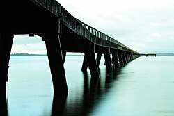
A coastal walkway through Kauri Point Historic Reserve connects Kauri Point to Ongare Point.[4] There are mature pōhutakawa trees and three pā sites in the reserve.[5][6] A 200 metre long wooden jetty, built after 1947, provides fishing access to the harbour.[7][8]
Dorothy Morris was a pioneer of the kiwifruit industry in New Zealand who she converted her dairy farm on Kauri Point Road to kiwifruit in the 1950s.[9]
George Vesey Stewart, who organised settlement of Katikati in the 1870s, initially planned for the town to be established at Kauri Point.[10] The settlement at Kauri Point did not eventuate until the 1970s.[11]
^Cite error: The named reference Area was invoked but never defined (see the help page).
^Cite error: The named reference Census 2018 was invoked but never defined (see the help page).
^Harriss, Gavin (August 2022). Kauri Point, Bay of Plenty (Map). NZ Topo Map.
^"Kauri Point – Ongare Point". motowalknz. 5 March 2016.
^Golson, J (1961). "Investigations at Kauri Point, Katikati, western Bay of Plenty". New Zealand Archaeological Association.
^Law, Garry (5 September 2016). "Kauri Point Pa". Archaeopedia New Zealand.
^"Jetty at Kauri Point". Bay of Plenty Times. 3 December 1947.
^"Kauri Point Historic Reserve". Western Bay of Plenty District Council. Retrieved 26 November 2022.
KauriPoint is a rural settlement in the Western Bay of Plenty District and Bay of Plenty Region of New Zealand's North Island. It is on a headland on...
The Defence Armament Depot, named the KauriPoint Armament Depot until 2010, is a New Zealand Defence Force munitions storage facility in the Auckland...
Agathis australis, or kauri, is a coniferous tree in the family Araucariaceae, found north of 38°S in the northern regions of New Zealand's North Island...
extends for over 2 kilometres across the harbour, to within 500 metres of KauriPoint on the northern shore. The reef was formed more than 28,000 years ago...
coastal reserves. Historically, Kauri trees were prominent in the area; it was a place where the Te Waiohua tribes collected Kauri resin as it was required to...
followers were killed. Ōngare Point-KauriPoint is defined by Statistics New Zealand as a rural settlement. Ongare Point covers 0.55 km2 (0.21 sq mi)....
staging point for shark fishing off KauriPoint on the inner Waitematā Harbour. As the city of Auckland grew, Point Chevalier gained strategic importance...
Base (1944-1945) US Navy Magazines, Motutapu Island US Navy Magazines, KauriPoint Armament Depot Fuel Tank Farm, Northcote, Auckland Avondale Naval Hospital...
Katikati KauriPoint Matahui Point Matakana Matakana Point Ngakautuakina Point Ongare Point Opureora Pahoia Rangiwaea Rereatukahia Pa Tahawai Tanners Point Tirohanga...
Land Information New Zealand. Retrieved 18 April 2021. "NZGB Gazetteer: KauriPoint Birkenhead / Te Mātā-rae-o-Mana". Land Information New Zealand. Retrieved...
Auckland Council. The island was initially exploited for its minerals and kauri trees and saw only limited agriculture. In 2013, it was inhabited by 939...
based at Devonport. The Navy's munitions are stored and maintained at KauriPoint Armament Depot in Auckland. Senior naval staff are located at the NZDF...
Waitematā Harbour, forming Te Tokaroa Reef, which reaches within 500 m of KauriPoint, Birkenhead. Some lava flows contain caves, for example at Wiri, Three...
south of the Hokianga Harbour. These kauri forests are also home to Te Raupua at 781 metres (2,562 ft), the highest point in the region. Northland has many...
prefabricated components, the difficulty in getting supplies of first-class kauri timber and a serious shortage of skilled labour. The newly formed RNZN commissioned...
Te Matua Ngahere is a giant kauri (Agathis australis) coniferous tree in the Waipoua Forest of Northland Region, New Zealand. The tree's Māori name means...
 Global Information