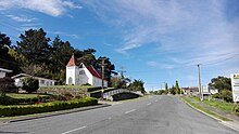
Kaiwaka, known as "the little town of lights",[1] is a settlement in Northland, New Zealand. The Kaiwaka River runs from the east through the area and joins with the Wairau River to form the Otamatea River, which drains into the Kaipara Harbour. State Highway 1 passes through Kaiwaka. Wellsford is 20 kilometres (12 mi) south, Brynderwyn is 8 kilometres (5.0 mi) north, and Whangārei, the closest city, is 60 kilometres (37 mi) (a 45-minute drive) to the north. The Mangawhai Heads are 18 kilometres (11 mi) northeast of Kaiwaka.[4][5]
The New Zealand Ministry for Culture and Heritage gives a translation of eating the canoes for Kaiwaka.[6] The reference to food and canoe may reflect the historic Mangapai portage route between Kaiwaka and Mangawhai linking the east coast with the Kaipara Harbour.[7]
Local tradition also speaks of a cloud that is only observed in this part of the Kaipara. It is seen as an omen that a high ranking person is about to pass on.[8]He kapua pōuri ngā kaiwaka kei runga i te paerangi. He tohu aituā tēnei (Te Ara 2015). / Kaiwaka are threatening clouds on the horizon. This a sign of misfortune.[9]
^ ab"2009 : 150 years of Kaiwaka, the little town of lights (record)". National Library of New Zealand. 2009.
^Cite error: The named reference Area was invoked but never defined (see the help page).
^"Subnational population estimates (RC, SA2), by age and sex, at 30 June 1996-2023 (2023 boundaries)". Statistics New Zealand. Retrieved 25 October 2023. (regional councils); "Subnational population estimates (TA, SA2), by age and sex, at 30 June 1996-2023 (2023 boundaries)". Statistics New Zealand. Retrieved 25 October 2023. (territorial authorities); "Subnational population estimates (urban rural), by age and sex, at 30 June 1996-2023 (2023 boundaries)". Statistics New Zealand. Retrieved 25 October 2023. (urban areas)
^Peter Dowling, ed. (2004). Reed New Zealand Atlas. Reed Books. pp. map 8. ISBN 0-7900-0952-8.
^Roger Smith, GeographX (2005). The Geographic Atlas of New Zealand. Robbie Burton. pp. map 31. ISBN 1-877333-20-4.
^"1000 Māori place names". New Zealand Ministry for Culture and Heritage. 6 August 2019.
^Hooker, Brian (September 1997). "Portages of early Auckland - to and from the Waitemata Harbour: The hub of an ancient communications network". folksong.org.nz. Retrieved 31 January 2021.
^A.W. Read, Revised by Peter Dowling (2010). Place Names of New Zealand. Penguin Group. p. 193. ISBN 9780143204107.
^"Kaiwaka". maoridictionary.co.nz. 2021. Retrieved 31 January 2021.
Kaiwaka, known as "the little town of lights", is a settlement in Northland, New Zealand. The Kaiwaka River runs from the east through the area and joins...
Mangawhai Heads is 5 km north-east, on the lower part of the harbour. Kaiwaka is 13 km south-west, and Waipu is 20 km north-west of Mangawhai Heads....
draining into Lake Tarawera by Awapurohe Creek and Rotomahana's outflow of Kaiwaka Stream. The eruption of Mount Tarawera initially destroyed Lake Rotomakariri...
The Kaiwaka River is a river of New Zealand's Northland Region. For much of its length, it is a broad arm of the Otamatea River, as much an inlet of the...
Mangawhai Harbour in the east, via the Otamatea River, Hakaru River and the Kaiwaka River. 45km 30miles 11 10 9 8 7 6 5 4 3 2 1 Portages formed important...
Lake Benmore) Karihoa Island (in Waikato River) Kaiwaka No.1 Island (in Waikato River delta) Kaiwaka No.2 Island (in Waikato River delta) Lee Island (in...
seen. The Tikitiki area has five marae belonging to Ngāti Porou hapū. Kaiwaka Marae and Te Kapenga meeting house is a meeting place of Ngāti Putaanga...
In addition, it took over the functions of the Raupo Drainage Board, Kaiwaka Reserve Board, and the Pahi Reserve Boards. Kaipara District is located...
of Lake Rotomahana and faced west to north west at the entrance to the Kaiwaka Channel. Te Tarata descended to the lake edge around 25 metres (82 ft)...
30 October 1953) is a Hungarian, Swiss, and New Zealand artist based in Kaiwaka, New Zealand. Panyoczki has exhibited in Switzerland, USA, Germany, Italy...
the Waiuku area was an important transportation hub, as the Te Pai o Kaiwaka portage was the preferred route for people travelling between the Waikato...
east of Rotomahana, with both lakes draining into Lake Tarawera via the Kaiwaka Stream. Much of the ground around Lake Rotomahana was warm to a few inches...
township. The traditional name of Awanui was Kaiwaka and Awanui proper refers to the "River at Kaiwaka". According to the 2013 New Zealand census, Awanui...
Country New Zealand Region Northland Region District Kaipara District Ward Kaiwaka-Mangawhai Ward Electorates Northland Te Tai Tokerau Government • Territorial...
and injuring 30 1923 Landslide 2 Little River Canterbury 1924 Flooding 1 Kaiwaka Hawke's Bay 1924 Landslide 1 Napier Hawke's Bay Slip happened on Shakespeare...
Araparera River, Hikurangi River, Hōteo River, Kaihu River, Kaipara River, Kaiwaka River, Kaukapakapa River, Kumeū River, Makarau River, Mangakahia River...
diving tender, sold for use as a pleasure craft in February 2010. HMNZS Kaiwaka T14 Converted merchant boat Danlayer 1941 1945 HMNZS Kaniere F426 Loch...
Zealand Navy during World War II HMNZS Coastguard (T12) HMNZS Ikatere HMNZS Kaiwaka (T14) HMNZS Nora Niven (T23) HMNZS Phyllis T22 HMNZS Waiho (T34) HMNZS...
 Global Information