This article is about the administrative region. For the former census division, see Inuvik Region, Northwest Territories (former census division).
Administrative region in the Northwest Territories, Canada
Administrative region in Northwest Territories, Canada
Inuvik Region
Administrative region
Skyline of the town of Inuvik
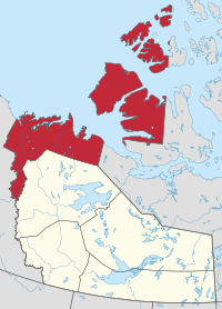
Location within the Northwest Territories
Country
Canada
Territory
Northwest Territories
Federal riding
Northwest Territories
Territorial ridings
Inuvik Boot Lake Inuvik Twin Lakes Mackenzie Delta Nunakput
Regional office[1]
Inuvik
Area
• Total
387,400 km2 (149,600 sq mi)
Population
(2016)
• Total
6,372
Time zone
UTC−07:00 (MST)
• Summer (DST)
UTC−06:00 (DST)
Aklavik
Fort McPherson
Inuvik
Paulatuk
Sachs Harbour
Tsiigehtchic
Tuktoyaktuk
Ulukhaktok
class=notpageimage|
Inuvik Region communities in the Northwest Territories
The Inuvik Region or Beaufort Delta Region is one of five administrative regions in the Northwest Territories of Canada. According to Municipal and Community Affairs the region consists of eight communities with the regional office situated in Inuvik.[1] Most of the communities are in the Beaufort Sea area and are a mixture of Inuit (Inuvialuit) and First Nations (mostly Gwich'in).
Formerly, there was also a Statistics Canada designated census division named Inuvik Region, Northwest Territories, which was abolished in the 2011 Canadian Census. The territorial extent of this census division was somewhat larger than the administrative region of the same name.
^ abInuvik Region
^Government of the Northwest Territories. "About Municipal and Community Affairs". Retrieved 2019-06-17.
Aklavik Fort McPherson Inuvik Paulatuk Sachs Harbour Tsiigehtchic Tuktoyaktuk Ulukhaktok The InuvikRegion or Beaufort Delta Region is one of five administrative...
Inuvik /ɪˈnuːvɪk/ (place of man) is the only town in the InuvikRegion, and the third largest community in Canada's Northwest Territories. Located in what...
Mackenzie River delta in the InuvikRegion of the Northwest Territories, Canada, at the northern terminus of the Inuvik–Tuktoyaktuk Highway. One of six...
Department of Natural Resources uses the same borders, but calls the InuvikRegion "Beaufort Delta". Land and self-government treaties with First Nations...
Arctic (/ˈɑːrtɪk/ or /ˈɑːrktɪk/) is a polar region located at the northernmost part of Earth. The Arctic region, from the IERS Reference Meridian travelling...
BC AB SK MB ON QC NB PE NS NL YT NT NU Map all coordinates using OpenStreetMap Download coordinates as: KML GPX (all coordinates) GPX (primary coordinates)...
the InuvikRegion. Inuvik, located on the East Channel of the Mackenzie Delta, approximately 100 km (62 mi) from the Arctic Ocean, is the region's administrative...
members of the Arctic Archipelago. Situated in the InuvikRegion, and part of the Inuvialuit Settlement Region, of the Northwest Territories, it is separated...
Inuvialuktun meaning barrenground grizzly place) is a hamlet located in the InuvikRegion of the Northwest Territories, Canada. Until 1961, with a population...
parentheses): Dehcho Region (Fort Simpson) InuvikRegion (Inuvik) North Slave Region (Yellowknife and Behchoko [sub-office]) Sahtu Region (Norman Wells) South...
A member of the Arctic Archipelago, Prince Patrick Island is the westernmost of the Queen Elizabeth Islands in the Northwest Territories of Canada, lying...
and parts of Melville Island, were transferred to the InuvikRegion. Baffin Island "Baffin region, Nunavut, Canada". Encyclopedia Britannica. The Editors...
Municipal and Community Affairs. Retrieved 2017-10-29. "NWT Communities - Inuvik". Government of the Northwest Territories: Department of Municipal and Community...
of the island lies in the InuvikRegion of the Northwest Territories; the remainder is part of Nunavut's Kitikmeot Region. The population of 2,168 is...
marginal sea of the Arctic Ocean located in the Qikiqtaaluk Region, Nunavut, and the InuvikRegion, Canada. It is situated among the islands of the Arctic...
Fort Simpson Jean Marie River Nahanni Butte Sambaa Kʼe Wrigley The Dehcho Region[pronunciation?] or Deh Cho is one of five administrative regions in the...
Paulatuk Water Aerodrome (TC LID: CEW8) is located in the Parry Peninsula's Darnley Bay near Paulatuk, Northwest Territories, Canada. It is open from July...
The North Slave Region or Tłicho Region is one of five administrative regions in the Northwest Territories of Canada. It is the most populous of the five...
a gulf located mainly in the InuvikRegion, Northwest Territories, Canada with a small section in the Kitikmeot Region of Nunavut. It lies between Banks...
in the InuvikRegion of the Northwest Territories, Canada. Situated on the southwestern coast of Banks Island in the Inuvialuit Settlement Region, the population...
Baillie Islands The Baillie Islands (Inuvialuktun: Utkraluk) are located off the north coast of Cape Bathurst in the Northwest Territories, Canada. The...
Cape Parry is a headland in Canada's Northwest Territories. Located at the northern tip of the Parry Peninsula, it projects into Amundsen Gulf. The nearest...
Slave Region is one of five administrative regions in the Northwest Territories of Canada. According to Municipal and Community Affairs the region consists...
 Global Information