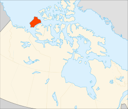
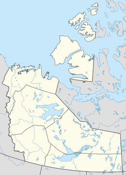
Inhabited island in the Northwest Territories, Canada
This article is about the island in the Canadian Arctic Archipelago. For the island in British Columbia, see Banks Island (British Columbia). For the group of islands in northern Vanuatu, see Banks Islands.
Banks Island
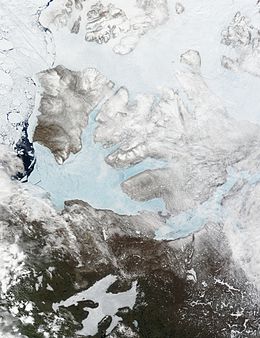
These moderate resolution imaging spectroradiometer images from June 14 and 16, 2002, show Banks Island (upper left) and Victoria Island (to the southeast)
Banks Island is one of the larger members of the Arctic Archipelago. Situated in the Inuvik Region, and part of the Inuvialuit Settlement Region, of the Northwest Territories, it is separated from Victoria Island to its east by the Prince of Wales Strait and from the mainland by Amundsen Gulf to its south. The Beaufort Sea lies to its west, and to its northeast M'Clure Strait separates the island from Prince Patrick Island and Melville Island.
It is home to at least fourteen mammal species including the Peary caribou, barren-ground caribou, and polar bears. At one time over 68,000 muskoxen lived on the island, the majority of the world's population. However, the bacterium Erysipelothrix rhusiopathiae has led to a sharp decline in their numbers. The island is the summer home to hundreds of thousands of migratory birds who nest at Banks Island Migratory Bird Sanctuary No. 1 and Banks Island Migratory Bird Sanctuary No. 2.[2][3]
As of the 2016 census it had a human population of 103, all in Sachs Harbour.[1]
^ ab"Census Profile, 2016 Census Sachs Harbour, Hamlet [Census subdivision], Northwest Territories and Northwest Territories [Territory]". 2016 Census. Statistics Canada.
^"Banks Island Migratory Bird Sanctuary No. 1". Environment and Climate Change Canada. 2022-06-03.
^"Banks Island Migratory Bird Sanctuary No. 2". Environment and Climate Change Canada. 2019-11-14.
1820 it was seen from Melville Island by Sir William Edward Parry and named "Banks Land" in honour of Sir Joseph Banks. However, during the later exploration...
The Outer Banks (frequently abbreviated OBX) are a 200 mi (320 km) string of barrier islands and spits off the coast of North Carolina and southeastern...
The BanksIslands (in Bislama Bankis) are a group of islands in northern Vanuatu. Together with the Torres Islands to their northwest, they make up the...
a complete blank from these two lands north to "Banks Land" which is the north coast of BanksIsland. In 1851 John Rae charted its entire south coast...
833°E / -43.750; 172.833 Banks Peninsula Banks Peninsula is a peninsula of volcanic origin on the east coast of the South Island of New Zealand. It has...
A recursive island or lake, also known as a nested island or lake, is an island or a lake that lies within a lake or an island. For the purposes of defining...
The Bank of the Philippine Islands (Filipino: Bangko ng Kapuluang Pilipinas; Spanish: Banco de las Islas Filipinas, commonly known as BPI; PSE: BPI) is...
Banks Peninsula on the South Island, New Zealand; the BanksIslands in modern-day Vanuatu; the Banks Strait between Tasmania and the Furneaux Islands;...
This list of islands by area includes all islands in the world larger than 2,500 km2 (970 sq mi) and most of the islands over 1,000 km2 (390 sq mi), sorted...
Roanoke Island (/ˈroʊənoʊk/) is an island in Dare County, bordered by the Outer Banks of North Carolina. It was named after the historical Roanoke, a...
Bodie Island (/ˈbɒdi/ BAH-dee) is a long, narrow barrier peninsula that forms the northernmost portion of the Outer Banks. The land that is most commonly...
The Central Bank Act of 1986 eliminated the ability of the Central Bank to regulate the interest rates of commercial banks and savings banks. Though nominally...
The Grand Banks of Newfoundland are a series of underwater plateaus south-east of the island of Newfoundland on the North American continental shelf. The...
the banks. In 2007, the Dongsha Atoll National Park was established on the island. The People's Republic of China claims the island, atoll and banks as...
source, the Spratly Islands consist of 14 islands or islets, 6 banks, 113 submerged reefs, 35 underwater banks, 21 underwater shoals. For some reason, neither...
misidentification of the Falkland Islands. The Baja California Peninsula and the Banks Peninsula in New Zealand each appear as islands on some early maps, but were...
periods. The muskox was already present in its current stronghold of BanksIsland 34,000 years ago, but the existence of other ice-free areas in the Canadian...
east at that point and reaching BanksIsland. McClure's ship was trapped in the ice for three winters near BanksIsland, at the western end of Viscount...
point of land was established, several gravel banks have been discovered in the sea to the north of the island, such as Oodaaq, 83-42, and ATOW1996; however...
North Carolina's Outer Banks. When John Shackleford first acquired his tract at Shackleford Banks, the island was known as "Cart Island", most likely after...
 Global Information