Uninhabited island in the Northwest Territories, Canada
Prince Patrick Island
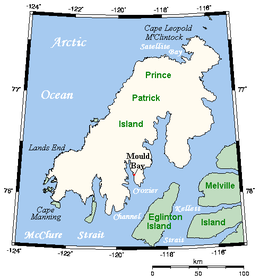
Prince Patrick Island, showing the Mould Bay weather station
Prince Patrick Island
Show map of Northwest Territories
Prince Patrick Island
Show map of Canada
Geography
Location
Northern Canada
Coordinates
76°45′02″N119°30′12″W / 76.75056°N 119.50333°W / 76.75056; -119.50333 (Prince Patrick Island)[1]
Archipelago
Queen Elizabeth Islands Arctic Archipelago
Area
15,848 km2 (6,119 sq mi)
Area rank
55th
Highest elevation
279 m (915 ft)
Highest point
unnamed
Administration
Canada
Territory
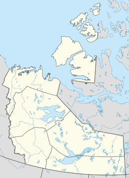
Northwest Territories
Demographics
Population
Uninhabited
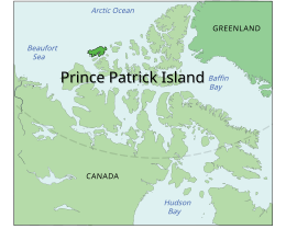
A member of the Arctic Archipelago, Prince Patrick Island is the westernmost of the Queen Elizabeth Islands in the Northwest Territories of Canada, lying northwest of Melville Island. The area of Prince Patrick Island is 15,848 km2 (6,119 sq mi),[2] making it the 55th largest island in the world and Canada's 14th largest island. It has historically been icebound all year, making it one of the least accessible parts of Canada. Located at the entrance of the M'Clure Strait, Prince Patrick Island is uninhabited.
The first known sighting of the island was in 1853 by the Irish naval officer George Mecham, when it was explored by him and his fellow Irish explorer Francis Leopold McClintock in the spring of that year during the Edward Belcher expedition.[3] Much later, it was named for Prince Arthur William Patrick, Duke of Connaught, who was Governor General of Canada from 1911 to 1916.
The island rises to only about 279 m (915 ft),[4] and the area is seismically active.
^"Prince Patrick Island". Geographical Names Data Base. Natural Resources Canada.
^Prince Patrick Island Archived 2013-01-22 at the Wayback Machine at the Atlas of Canada
^M'Dougall, George F. (1857). The eventful voyage of H.M. discovery ship "Resolute" to the Arctic regions, in search of Sir John Franklin and the missing crews of H.M. discovery ships "Erebus" and "Terror," 1852, 1853, 1854. London: Longman, Brown, Green, Longmans, & Roberts. p. 452. The Eventful Voyages of HMS Resolute.
^Prince Patrick Island High Point, Northwest Territories
and 26 Related for: Prince Patrick Island information
PrincePatrickIsland is the westernmost of the Queen Elizabeth Islands in the Northwest Territories of Canada, lying northwest of Melville Island. The...
Island, Eglinton Island, Ellef Ringnes Island, Mackenzie King Island, Melville Island, and PrincePatrickIsland. Other smaller but notable islands include;...
This is a list of numbered highways in the province of Prince Edward Island. Prince Edward Island relies mostly on arterial roads for major inter-city routes...
and to its northeast M'Clure Strait separates the island from PrincePatrickIsland and Melville Island. It is home to at least fourteen mammal species...
of Wrangel Island to Point Barrow – the Northern limit of Chuckchi Sea [sic]. From Point Barrow to Cape Land's End on PrincePatrickIsland – the Northern...
uninhabited island, desert island, or deserted island, is an island, islet or atoll that is not permanently populated by humans. Uninhabited islands are often...
of the islands on the region's west side that remained in the NWT, including Eglinton Island, PrincePatrickIsland and parts of Melville Island, were...
Christian Island Little Cornwallis Island Lougheed Island Mackenzie King Island Massey Island Meighen Island North Kent Island Pioneer IslandPrincePatrick Island...
This list of islands by area includes all islands in the world larger than 2,500 km2 (970 sq mi) and most of the islands over 1,000 km2 (390 sq mi), sorted...
Prince Edward Island [Province] and Canada [Country] (Prince Edward Island)". Statistics Canada. Retrieved 2018-08-08. "Joshua Calder's World Island Info...
the much larger PrincePatrickIsland and is uninhabited with no known human activity. The first European sighting of Eglinton Island was in 1853 by George...
Northwest Territories of Canada. It separates PrincePatrickIsland (to the south-west) and Brock Island (to the north-east). It opens into the Arctic...
Southwest coast of PrincePatrickIsland to Griffiths Point, thence a line to Cape Prince Alfred, the Northwestern extreme of Banks Island, through its West...
north are Devon Island, Wellington Channel, Cornwallis Island, McDougall Sound, Bathurst Island, Melville Island and PrincePatrickIsland. Parry Channel...
film is set in 1907. Instead of PrincePatrickIsland, the island in the film is located due north of Ellesmere Island (cf. Crocker Land). Several extra...
Territorial islands in the Canadian Arctic Archipelago include Banks Island, Borden Island, PrincePatrickIsland, and parts of Victoria Island and Melville...
Southwest coast of PrincePatrickIsland to Griffiths Point, thence a line to Cape Prince Alfred, the Northwestern extreme of Banks Island, through its West...
Prince Charles Island is a large, low-lying island in Canada. With an area of 9,521 km2 (3,676 sq mi), it is the world's 77th largest island and the 19th...
Tobias Alistair Patrick Kebbell (born 9 July 1982) is an English actor. He is known for his roles in films such as Dead Man's Shoes (2004), Control (2007)...
This is a list of parishes for the Canadian province of Prince Edward Island. North Parish Egmont Parish Halifax Parish Richmond Parish St. David's Parish...
King George III of England" on 11 August. The island was renamed Prince of Wales Island after the heir to the British throne and the new settlement of George...
Northwest Territories of Canada. It separates PrincePatrickIsland (to the north-west) and Eglinton Island (to the south-east). It opens into the McClure...
The Prince Edward Island Cables connect the electric grid on Prince Edward Island with the mainland in New Brunswick. The two cables have a length of...
 Global Information