Mount Gongga, the tallest summit in the Hengduan Mountains
Highest point
Peak
Mount Gongga
Elevation
7,556 m (24,790 ft)
Geography
Countries
China and Burma
Range coordinates
27°30′N99°00′E / 27.5°N 99°E / 27.5; 99
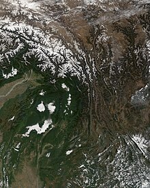
Three Parallel Rivers region - heart of Hengduan Shan - relative to South, Southeast and East Asia.Larger scale political / relief map of area (Hengduan Shan / Three Gorges region top centre).Map of East Asia, showing location of Hengduan Mountains (with particular reference to their coniferous forests) and their only major settlement Lijiang, Yunnan Province.Satellite view of the Hengduan Mountains
The Hengduan Mountains (simplified Chinese: 横断山脉; traditional Chinese: 橫斷山脈; pinyin: Héngduàn Shānmài) are a group of mountain ranges in southwest China that connect the southeast portions of the Tibetan Plateau with the Yunnan–Guizhou Plateau. The Hengduan Mountains are primarily large north-south mountain ranges that effectively separate lowlands in northern Myanmar from the lowlands of the Sichuan Basin. These ranges are characterized by significant vertical relief originating from the Indian subcontinent's collision with the Eurasian Plate, and further carved out by the major rivers draining the eastern Tibetan Plateau. These rivers, the Yangtze, Mekong, and Salween, are recognized today as the Three Parallel Rivers UNESCO World Heritage Site.
The Hengduan Mountains cover much of western present-day Sichuan province as well as the northwestern portions of Yunnan, the easternmost section of the Tibet Autonomous Region, and touching upon parts of southern Qinghai. Additionally, some parts of eastern Kachin State in neighbouring Myanmar are considered part of the Hengduan group. The Hengduan Mountains are approximately 900 kilometres (560 mi) long, stretching from 33°N to 25°N. Depending on extent of the definition, the Hengduan Mountains are also approximately 400 kilometres (250 mi) wide under the narrowest definition, ranging from 98°E to 102°E. The area covered by these ranges roughly corresponds with the Tibetan region known as Kham.
The Hengduan Mountains subalpine conifer forests is a palaearctic ecoregion in the Temperate coniferous forests biome that covers portions of the mountains.
and 27 Related for: Hengduan Mountains information
The HengduanMountains (simplified Chinese: 横断山脉; traditional Chinese: 橫斷山脈; pinyin: Héngduàn Shānmài) are a group of mountain ranges in southwest China...
Sichuan province in Southwest China. It is part of the HengduanMountains, a complicated system of mountain ranges of western Sichuan, which itself is adjacent...
The HengduanMountains subalpine conifer forests are a temperate forest in the HengduanMountains of southwestern China. The forests extend within the...
into the "montane grassland and shrubland" biome. A region in the HengduanMountains adjoining Asia's Tibetan Plateau have been identified as the world's...
east. The Meili are subrange of the larger Nu Mountains, themselves a constituent range of the Hengduan group. The crest of the range rises to over 6...
and Haba Snow Mountain. The Yulong Mountains lie to the south of the Yun Range and are part of Southwest China's greater HengduanMountains. Settlements...
Arakan/Rakhine Mountains – 950 km (590 mi) HengduanMountains – 900 km (560 mi) as a system of mountain ranges Ogo Mountains – 900 km (560 mi) Koryak Mountains – 880 km...
the northwestern Myanmar. The ecoregions in the hotspot include: HengduanMountains subalpine conifer forests Nujiang Lancang Gorge alpine conifer and...
the name was applied to the Min Mountains, Qionglai Mountains, Daxue Mountains and other ranges in the HengduanMountains. In this context the province...
northeastern India where the Himalaya are said to end, although high ranges (HengduanMountains on the China–Myanmar border) actually continue another 300 km to the...
Snow Mountain massif is considered the southernmost extent of the expansive Shaluli Mountains, themselves a component range of the HengduanMountains. Three...
the Taniantaweng Mountains, the Gaoligong Mountains, the Nu Mountains, and the Yun Range. The mountains in this region of the Hengduan are steep and provide...
incomplete list of notable mountains on Earth, sorted by elevation in metres above sea level. For a complete list of mountains over 7200 m high, with at...
the World Wildlife Fund as the Qionglai-Minshan conifer forests. HengduanMountains Yaomei Feng, China "Qionglai-Minshan conifer forests". Terrestrial...
India), where the Himalaya are said to end, although high ranges (HengduanMountains on China–Myanmar border) actually continue another 300 km east. Major...
Homotherium hengduanshanense was described based on fossils from the HengduanMountains. There is currently only one recognised species Homotherium in Eurasia...
Chinese: 納西族; pinyin: Nàxī zú; Naxi: Naqxi) are a people inhabiting the HengduanMountains abutting the Eastern Himalayas in the northwestern part of Yunnan...
spectacular mountains that are connected via a high ridge to a taller summit, such as Eiger, Nuptse or Annapurna IV. A few such peaks and mountains with nearly...
Himalaya has Indo-Gangetic Plain in south, Pamir Mountains in west in Central Asia, and HengduanMountains in east on China–Myanmar border. From east to...
Formation in the Rhön Mountains, central Germany. Achenes labelled Ranunculus cf. tachiroei is known from the Pliocene of the HengduanMountains of China. Indeterminate...
that the species is most closely related to L. omeiensis with the HengduanMountains possibly acting as the isolating barrier between the two. All sightings...
Hindu Kush, Kunlun Mountains, Tian Shan, Karakoram, Pamir-Alay and HengduanMountains The Encyclopedia Americana: a library of universal knowledge, p. 687...
significance. The Sichuan basin is surrounded by the HengduanMountains to the west, the Qin Mountains to the north, and Yungui Plateau to the south. Since...
and Yangtze rivers in northwest Yunnan and western Sichuan (the HengduanMountains). In the west, the curve of the rugged Karakoram range of northern...
In China, it inhabits the HengduanMountains subalpine conifer forests and Qionglai-Minshan conifer forests in the Hengduan, Qionglai, Xiaoxiang, Daxiangling...
Plateau, the Tibetan Plateau, and the HengduanMountains. The Ailao Mountain Nature Reserve, located in the Ailao Mountains, is the best-preserved example of...
 Global Information