Height based on large area surrounding object; often used in U.S. for antenna towers
"EHAAT" redirects here. For the air ambulance service, see Essex & Herts Air Ambulance.
Height above average terrain (HAAT), or (less popularly) effective height above average terrain (EHAAT), is the vertical position of an antenna site above the surrounding landscape. HAAT is used extensively in FM radio and television, as it is more important than effective radiated power (ERP) in determining the range of broadcasts (VHF and UHF in particular, as they are line of sight transmissions). For international coordination, it is officially measured in meters, even by the Federal Communications Commission in the United States, as Canada and Mexico have extensive border zones where stations can be received on either side of the international boundaries. Stations that want to increase above a certain HAAT must reduce their power accordingly, based on the maximum distance their station class is allowed to cover (see List of North American broadcast station classes for more information on this).
The FCC procedure to calculate HAAT is: from the proposed or actual antenna site, either 12 or 16 radials were drawn, and points at 2, 4, 6, 8, and 10 miles (16 km) radius along each radial were used. The entire radial graph could be rotated to achieve the best effect for the station. The altitude of the antenna site, minus the average altitude of all the specified points, is the HAAT. This can create some unusual cases, particularly in mountainous regions—it is possible to have a negative number for HAAT (the transmitter would not be located underground, but rather in a valley, with hills on both sides taller than the transmitter itself, for example).
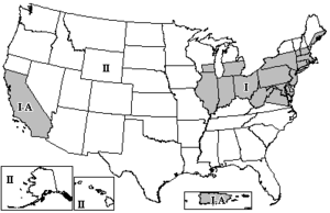
The FCC has divided the Contiguous United States into three zones for the determination of spacing between FM and TV stations using the same frequencies. FM and TV stations are assigned maximum ERP and HAAT values, depending on their assigned zones, to prevent co-channel interference.
FM broadcast zones in the U.S.
The FCC regulations for ERP and HAAT are listed under Title 47, Part 73 of the Code of Federal Regulations (CFR).
and 23 Related for: Height above average terrain information
Heightaboveaverageterrain (HAAT), or (less popularly) effective heightaboveaverageterrain (EHAAT), is the vertical position of an antenna site above...
mean sea level (AMSL or HAMSL), heightabove ellipsoid (HAE, as reported by a GPS receiver), or heightaboveaverageterrain (AAT or HAAT, in broadcast engineering)...
relative lowering of mean sea level. Depth below seafloor HeightaboveaverageterrainHeightabove ground level List of places on land with elevations below...
topographic isolation, and a negative topographic elevation. Heightaboveaverageterrain (HAAT) – a similar measurement for FM and TV transmitters Jut...
of redirect targets Geopotential height – Type of altitude above mean sea level Heightaboveaverageterrain – Height based on large area surrounding object;...
restrictions vary depending on the class of license and the antenna heightaboveaverageterrain (HAAT). Some stations have been grandfathered in or, very infrequently...
watts, broadcasting from a tower at 829 meters (2,720 ft) in heightaboveaverageterrain (HAAT). The transmitter is on Tower Mountain Road in Crown King...
States, Canada and Mexico. Effective radiated power (ERP) and heightaboveaverageterrain (HAAT) are listed unless otherwise noted. All radio and television...
limited due to a heightaboveaverageterrain of only 136 meters (446 feet). Some Bay Area FM stations have towers three times that height. KSJO-FM1, a 67-watt...
100.1 FM with an effective radiated power of 25 watts, at a heightaboveaverageterrain (HAAT) of 46 meters. There is a streaming feed available at wbrs...
000 watts. It transmits from a tower 707 meters (2,320 ft) in heightaboveaverageterrain (HAAT) near Issaquah, Washington, on Tiger Mountain. KNDD broadcasts...
(ERP) of 100,000 watts, from a tower at 1,014 feet (309 m) in heightaboveaverageterrain (HAAT). Its signal stretches from the Georgia coast to south...
97 watts, equivalent to several hundred watts because of the heightaboveaverageterrain of over 700 meters, or more than 2,300 feet. Both stations will...
of 15,000 watts, from a tower at 366 meters (1,201 feet) in heightaboveaverageterrain. KITS broadcasts in the HD Radio format; its HD2 subchannel formerly...
watts, broadcasting from a tower at 638.3 meters (2,094 feet) in heightaboveaverageterrain (HAAT). The transmitter is on Morrisey Lane in Mariposa, California...
effective radiated power (ERP) in a given direction, the radial heightaboveaverageterrain (HAAT) in a given direction, the FCC's propagation curves[1]...
antenna mounted at the 284 m (932 ft) level. The calculated HeightAboveAverageTerrain is 311 m (1,020 ft). The FM antenna array is a FM10/8 manufactured...
has an effective radiated power (ERP) of 190,000 watts from a heightaboveaverageterrain (HAAT) of 361 feet (110 meters). It is grandfathered at a much...
near Golden, more than 7,000 feet (2256 m) above sea level and 1,135 feet (346 m) in heightaboveaverageterrain. Its effective radiated power is 100,000...
Briceville, Tennessee. Its tower is at 618.2 meters (2,028 feet) in heightaboveaverageterrain (HAAT). That elevation means its signal can be received around...
 Global Information