Endorheic basin adjoining the Continental Divide in southern Wyoming, USA
Not to be confused with Great Basin Divide or Great Basin.
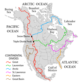
Great Divide Basin
The Great Divide Basin (the uppermost "loop" on the map above) is an endorheic drainage basin on the Continental Divide (red line) in the United States.
The Great Divide Basin or Great Divide Closed Basin[3] is an area of land in the Red Desert of Wyoming where none of the water falling as rain to the ground drains into any ocean, directly or indirectly. It is thus an endorheic basin, one of several in North America that adjoin the Continental Divide. To the south and west of the basin is the Green River watershed, draining to the Gulf of California/Pacific Ocean; to the north and east is the North Platte watershed, draining to the Gulf of Mexico. The basin is very roughly rectangular in shape; the northwest corner is at Oregon Buttes near South Pass, about 40 miles (64 km) southwest of Lander, and the southeast corner is in the Sierra Madre Range near Bridger Pass, about 20 miles (32 km) southwest of Rawlins.[4][5]
^U.S. Geological Survey Geographic Names Information System: Great Divide Basin
^"Statewide Data Inventory - Green River/Great Divide Basin Introduction". Waterplan.state.wy.us. Archived from the original on 2016-09-21. Retrieved 2008-12-05.
^"Great Divide Closed Basin Watershed -- 14040200". cfpub.epa.gov. United States Environmental Protection Agency. Archived from the original on 2011-07-21. Retrieved 2010-04-24.
^"Select Area of Interest". www.wsgs.uwyo.edu. Wyoming State Geological Survey. Archived from the original on 2012-02-24. Retrieved 2010-04-24. (Great Basin Divide Archived 2011-07-20 at the Wayback Machine, Washakie Basin Archived 2012-02-24 at the Wayback Machine)
^Francis, Julie. "The Great Divide and Green River Basins". Wyoming State Geological Survey. Archived from the original on May 9, 2021. Retrieved December 30, 2021.
and 25 Related for: Great Divide Basin information
The GreatDivideBasin or GreatDivide Closed Basin is an area of land in the Red Desert of Wyoming where none of the water falling as rain to the ground...
(secondary coordinates) The GreatBasinDivide in the western United States is the ridgeline that separates the GreatBasin from the Pacific Ocean watershed...
The Continental Divide of the Americas (also known as the GreatDivide, the Western Divide or simply the Continental Divide; Spanish: Divisoria continental...
continental divide is a drainage divide on a continent such that the drainage basin on one side of the divide feeds into one ocean or sea, and the basin on the...
GreatDivide or The GreatDivide may refer to: Continental Divide of the Americas, the most common meaning GreatDivideBasin, an endorheic drainage basin...
coordinates) A triple divide or triple watershed is a point on Earth's surface where three drainage basins meet. A triple divide results from the intersection...
"drains" in the GreatBasin. The Salton Sink is another closed basin within the GreatBasin. The GreatBasinDivide separates the GreatBasin from the watersheds...
Green River Basin is subdivided into four smaller basins, the Green River Basin, GreatDivideBasin, Washakie Basin, and Sand Wash Basin. Each of these...
drainage divide, water divide, ridgeline, watershed, water parting or height of land is elevated terrain that separates neighboring drainage basins. On rugged...
which divide the continent into seven principal drainage basins spanning three oceans (Arctic, Atlantic and Pacific) and one endorheic basin. The basins are...
Frequency divider, a circuit that divides the frequency of a clock signal Drainage divide, a line separating two drainage basinsGreatDivideBasin, in Wyoming...
mineral or salt buildup. The GreatDivideBasin in Wyoming, a small endorheic basin that straddles the Continental Divide of the Americas. Devils Lake...
Basin and GreatDivideBasins, and is demarcated by the following: southwest: Uinta Mountains west: west side of Green River watershed Wyoming Basin shrub...
on the Continental Divide of the Americas near the south GreatDivideBasin bifurcation point, i.e., the point at which the divide appears to split and...
hydrological divides of North America which define several drainage basins, each of which drains to a particular body of water. Eastern Triple Divide The Eastern...
of water, such as a lake or ocean. A basin is separated from adjacent basins by a perimeter, the drainage divide, made up of a succession of elevated...
folding processes. The crests of the GreatDividing Range is defined by the watershed boundary between the drainage basins of river systems east (the coastal...
The Great Artesian Basin (GAB), located in Australia, is the largest and deepest artesian basin in the world, stretching over 1,700,000 square kilometres...
The GreatDivide Mountain Bike Route (GDMBR) is a 3,083.8 mi (4,962.9 km), off-road bicycle touring route between Jasper, Alberta, Canada and Antelope...
the Palmer Divide is a caprock escarpment-style ridge in central Colorado that separates the Arkansas River basin from the South Platte basin. It extends...
enters the GreatDivideBasin, an endorheic basin between two branches of the Continental Divide. I-80 and US 30 pass by the only town in the basin, Wamsutter...
(Nebraska) White Woman Basin (Kansas) Devil's Lake (Wisconsin) -- cryptorheic GreatDivideBasin (Wyoming) San Luis Closed Basin (Colorado) Crater Lake...
the Pacific Ocean. However, a large endorheic drainage called the GreatDivideBasin exists between the Missouri and Green watersheds in western Wyoming...
 Global Information