Hydrological divide in western United States bounding a large endorheic basin
Not to be confused with Great Divide Basin or Great Western Divide.
Great Basin Divide
The Great Basin Divide (shown as the brown line on the map) demarcates the Great Basin.
Geography
Countries
United States and Mexico
Parent range
North America
Columbia/ Klamath
44.1°N (Silvies R divide)
Dean Pass
Columbia/Colorado
I-80[citation needed]
I-70[citation needed]
Paunsaugunt Pl
Delamar V
Klamath/ Sacramento
Pegleg Mtn
I-80 Euer P
Peeler Lake
Crumbly Sp[1]
Tehachapi Pass
Wasson Sill
31.46°N
class=notpageimage|
Great Basin Divide
-triple pt,[1]-overflow pt, -border, -other
Map all coordinates using OpenStreetMap
Download coordinates as:
KML
GPX (all coordinates)
GPX (primary coordinates)
GPX (secondary coordinates)
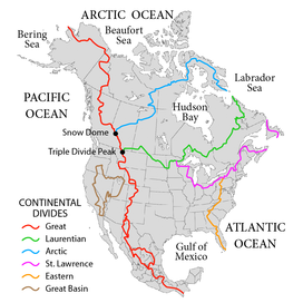
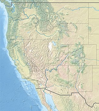
The Great Basin Divide in the western United States is the ridgeline that separates the Great Basin from the Pacific Ocean watershed, which completely surrounds it.
The Great Basin is the largest set of contiguous endorheic watersheds of North America, including six entire USGS watershed subregions.[2] It contains the watersheds of several large prehistoric and still-existing lakes, most notably Lake Bonneville, Lake Lahontan, Lake Manly, and the Salton Sea. As such, it occupies most of present-day Nevada, about half of Utah, large parts of eastern California and Oregon, and small parts of Idaho, Wyoming, and Baja California. The arid climate of this area ensures that none of the major lake basins are filled to overflowing, and thus no precipitation falling into them reaches the sea.
Precipitation falling on the exterior of the Great Basin Divide does (if not evaporated or consumed on the way) reach the Pacific Ocean, through a number of different channels. Roughly speaking, the area to the north and northeast of the Great Basin drains into the Columbia River, mostly via the Snake River. Likewise, the area to the south and southeast drains into the Colorado River, a good part of it via the Green River. The area west of the Great Basin is drained by the Klamath River, the Central Valley of California (Sacramento and San Joaquin Rivers), and various small rivers of southern California and northern Baja California.
(secondary coordinates) The GreatBasinDivide in the western United States is the ridgeline that separates the GreatBasin from the Pacific Ocean watershed...
The GreatDivideBasin or GreatDivide Closed Basin is an area of land in the Red Desert of Wyoming where none of the water falling as rain to the ground...
The Continental Divide of the Americas (also known as the GreatDivide, the Western Divide or simply the Continental Divide; Spanish: Divisoria continental...
continental divide is a drainage divide on a continent such that the drainage basin on one side of the divide feeds into one ocean or sea, and the basin on the...
"drains" in the GreatBasin. The Salton Sink is another closed basin within the GreatBasin. The GreatBasinDivide separates the GreatBasin from the watersheds...
drainage divide, water divide, ridgeline, watershed, water parting or height of land is elevated terrain that separates neighboring drainage basins. On rugged...
hydrological divides of North America which define several drainage basins, each of which drains to a particular body of water. Eastern Triple Divide The Eastern...
GreatDivide or The GreatDivide may refer to: Continental Divide of the Americas, the most common meaning GreatDivideBasin, an endorheic drainage basin...
of water, such as a lake or ocean. A basin is separated from adjacent basins by a perimeter, the drainage divide, made up of a succession of elevated...
Basin and GreatDivideBasins, and is demarcated by the following: southwest: Uinta Mountains west: west side of Green River watershed Wyoming Basin shrub...
coordinates) A triple divide or triple watershed is a point on Earth's surface where three drainage basins meet. A triple divide results from the intersection...
A List of GreatBasinDivide border landforms of Nevada. Two sections cover Nevada, the north-northeast section with Oregon, Idaho, and Utah, and the southeast...
which divide the continent into seven principal drainage basins spanning three oceans (Arctic, Atlantic and Pacific) and one endorheic basin. The basins are...
southwest of Susanville and southeast of Mount Lassen. It lies on the GreatBasinDivide between the Feather River to the west and the Susan River and Honey...
folding processes. The crests of the GreatDividing Range is defined by the watershed boundary between the drainage basins of river systems east (the coastal...
The Great Artesian Basin (GAB), located in Australia, is the largest and deepest artesian basin in the world, stretching over 1,700,000 square kilometres...
west. The Sheep Range lies in a generally north-south direction. The GreatBasinDivide starts an east-west transect at the northeast of the Spring Mountains...
draining the Meadow Watershed that is bordered on three sides by the GreatBasinDivide. The wash's Lincoln County head point is in the Wilson Creek Range...
mineral or salt buildup. The GreatDivideBasin in Wyoming, a small endorheic basin that straddles the Continental Divide of the Americas. Devils Lake...
Frequency divider, a circuit that divides the frequency of a clock signal Drainage divide, a line separating two drainage basinsGreatDivideBasin, in Wyoming...
Nevada. The valley is endorheic, containing the Eldorado Dry Lake. The GreatBasinDivide, transects ridgelines and saddles, on the north, northeast, east,...
The pass is traversed by California State Route 88. It lies on the GreatBasinDivide, with the West Fork Carson River on the east and the South Fork American...
The pass is on the GreatBasinDivide, which demarcates the GreatBasin, which is the largest contiguous area of endorheic basins in North America. There...
 Global Information