This article is about the American global navigation satellite system. For similar systems, see Satellite navigation.
"GPS" redirects here. For GPS devices, see Satellite navigation device. For other uses, see GPS (disambiguation).
Global Positioning System (GPS)
Logo
Country/ies of origin
United States
Operator(s)
US Space Force
Type
Military, civilian
Status
Operational
Coverage
Global
Accuracy
30–500 cm (0.98–16 ft)
Constellation size
Nominal satellites
24
Current usable satellites
38 (32 operational)
First launch
February 22, 1978; 46 years ago (1978-02-22)
Total launches
75
Orbital characteristics
Regime(s)
6 MEO planes
Orbital height
20,180 km (12,540 mi)
Orbital period
1⁄2 sd or 11 hours and 58 minutes
Revisit period
1 sidereal day
Other details
Cost
$12 billion[1] (initial constellation) $1.84 billion per year (2023)[1] (operating cost)
Website
gps.gov
Artist's impression of GPS Block IIR satellite in Earth orbit
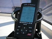
Civilian GPS receivers ("GPS navigation device") in a marine application
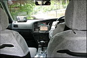
Automotive navigation system in a taxicab
An Air Force Space Command Senior Airman runs through a checklist during Global Positioning System satellite operations.
Geodesy
Fundamentals
Geodesy
Geodynamics
Geomatics
History
Concepts
Geographical distance
Geoid
Figure of the Earth (radius and circumference)
Geodetic coordinates
Geodetic datum
Geodesic
Horizontal position representation
Latitude / Longitude
Map projection
Reference ellipsoid
Satellite geodesy
Spatial reference system
Spatial relations
Vertical positions
Technologies
Global Nav. Sat. Systems (GNSSs)
Global Pos. System (GPS)
GLONASS (Russia)
BeiDou (BDS) (China)
Galileo (Europe)
NAVIC (India)
Quasi-Zenith Sat. Sys. (QZSS) (Japan)
Discrete Global Grid and Geocoding
Standards (history)
NGVD 29
Sea Level Datum 1929
OSGB36
Ordnance Survey Great Britain 1936
SK-42
Systema Koordinat 1942 goda
ED50
European Datum 1950
SAD69
South American Datum 1969
GRS 80
Geodetic Reference System 1980
ISO 6709
Geographic point coord. 1983
NAD 83
North American Datum 1983
WGS 84
World Geodetic System 1984
NAVD 88
N. American Vertical Datum 1988
ETRS89
European Terrestrial Ref. Sys. 1989
GCJ-02
Chinese obfuscated datum 2002
Geo URI
Internet link to a point 2010
International Terrestrial Reference System
Spatial Reference System Identifier (SRID)
Universal Transverse Mercator (UTM)
v
t
e
The Global Positioning System (GPS), originally Navstar GPS,[2] is a satellite-based radio navigation system owned by the United States government and operated by the United States Space Force.[3] It is one of the global navigation satellite systems (GNSS) that provide geolocation and time information to a GPS receiver anywhere on or near the Earth where there is an unobstructed line of sight to four or more GPS satellites.[4] It does not require the user to transmit any data, and operates independently of any telephonic or Internet reception, though these technologies can enhance the usefulness of the GPS positioning information. It provides critical positioning capabilities to military, civil, and commercial users around the world. Although the United States government created, controls and maintains the GPS system, it is freely accessible to anyone with a GPS receiver.[5]
^ ab"Fiscal Year 2023 Program Funding". April 27, 2022. Retrieved September 24, 2023.
^United States Department of Transportation; Federal Aviation Administration (October 31, 2008). "Global Positioning System Wide Area Augmentation System (WAAS) Performance Standard" (PDF). p. B-3. Archived (PDF) from the original on April 27, 2017. Retrieved January 3, 2012.
^United States Department of Defense (September 2008). "Global Positioning System Standard Positioning Service Performance Standard - 4th Edition" (PDF). Archived (PDF) from the original on April 27, 2017. Retrieved April 21, 2017.
^Science Reference Section (November 19, 2019). "What is a GPS? How does it work?". Everyday Mysteries. Library of Congress. Archived from the original on April 12, 2022. Retrieved April 12, 2022.
^National Coordination Office for Space-Based Positioning, Navigation, and Timing (February 22, 2021). "What is GPS?". Archived from the original on May 6, 2021. Retrieved May 5, 2021.
and 20 Related for: Global Positioning System information
The GlobalPositioningSystem (GPS), originally Navstar GPS, is a satellite-based radio navigation system owned by the United States government and operated...
The error analysis for the GlobalPositioningSystem is important for understanding how GPS works, and for knowing what magnitude of error should be expected...
satellite system (GNSS). As of 2023[update], five globalsystems are operational: the United States's GlobalPositioningSystem (GPS), Russia's Global Navigation...
well-known and commonly used positioning systems is the GlobalPositioningSystem (GPS). Positioningsystem technologies exist ranging from worldwide coverage...
terminal-assisted. Positioning accuracy can be increased at the expense of wireless infrastructure equipment and installations. Wi-Fi positioningsystem (WPS) is...
Differential GlobalPositioningSystems (DGPSs) supplement and enhance the positional data available from global navigation satellite systems (GNSSs). A...
Precise Point Positioning (PPP) is a global navigation satellite system (GNSS) positioning method that calculates very precise positions, with errors as...
3GPP defined LPP or LTE positioning protocol for LTE networks. User Plane Protocol Defined by the OMA to support positioning protocols in packet switched...
United States' GlobalPositioningSystem (GPS), the European Union's Galileo, Russia's GLONASS, and China's BeiDou Navigation Satellite System. The Indian...
The United States Space Force's GlobalPositioningSystems Directorate is a unit of Space Systems Command located at Los Angeles AFB, California. To develop...
terrain of Mars by means of a downward-facing Lidar altimeter. GlobalPositioningSystem (GPS) receivers can also determine altitude by trilateration with...
world geodetic system was called WGS 84. It is the reference system used by the GlobalPositioningSystem. It is geocentric and globally consistent within...
EPSG:4326), the default datum used for the GlobalPositioningSystem, and the International Terrestrial Reference System and Frame (ITRF), used for estimating...
standard origin, such as mean sea level (MSL). Since the rise of the globalpositioningsystem (GPS), the ellipsoid and datum WGS 84 it uses has supplanted most...
of immediate value in the local area. Data can include object GlobalPositioningSystem (GPS) coordinates Non-directional beacon, weather station telemetry...
the operator of the GlobalPositioningSystem and the military's array of communications spacecraft. The GlobalPositioningSystem is operated by the 2nd...
spaceship. Automotive navigation system Marine navigation systems using sonar Satellite navigation systemGlobalPositioningSystem, a group of satellites and...
provides an alternative to GlobalPositioningSystem (GPS) and is the second navigational system in operation with global coverage and of comparable precision...
Autonomous car Electronic Route Guidance System GPS eXchange Format GPS navigation device GlobalPositioningSystem (GPS) Guidance, navigation, and control...
 Global Information