Đồng Nai river (longest inland river) 586 kilometres (364 mi)
Largest lake
Ba Bể Lake 6.5 square kilometres (2.5 sq mi)
Exclusive economic zone
417,663 km2 (161,261 sq mi)
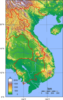
Regions of VietnamTopographic map of Vietnam
Vietnam is located on the eastern margin of the Indochinese peninsula and occupies about 331,211.6 square kilometres (127,881.5 sq mi), of which about 25% was under cultivation in 1987. It borders the Gulf of Tonkin, Gulf of Thailand, and Pacific Ocean, along with China, Laos, and Cambodia. The elongated roughly S shaped country has a north-to-south distance of 1,650 km (1,030 mi) and is about 50 km (31 mi) wide at the narrowest point. With a coastline of 3,260 km (2,030 mi), excluding islands, Vietnam claims 12 nautical miles (22.2 km; 13.8 mi) as the limit of its territorial waters, an additional 12 nautical miles (22.2 km; 13.8 mi) as a contiguous customs and security zone. It has an exclusive economic zone of 417,663 km2 (161,261 sq mi) with 200 nautical miles (370.4 km; 230.2 mi).
The boundary with Laos was settled on both an ethnic and geographical basis between the rulers of Vietnam and Laos in the mid-seventeenth century. The Annamite Range as a reference, was formally defined by a delimitation treaty signed in 1977 and ratified in 1986. The frontier with Cambodia, defined at the time of French annexation of the western part of the Mekong Delta in 1867, remained essentially unchanged, according to Hanoi, until some unresolved border issues were finally settled in the 1982–85 period. The land and sea boundary with China, delineated under the France-China treaties of 1887 and 1895, is "the frontier line" accepted by Hanoi. China agreed in 1957–58 to respect that border line. However, in February 1979, following the Sino-Vietnamese War, Hanoi complained that from 1957 onward China had provoked numerous border incidents as part of its anti-Vietnam policy and expansionist designs in Southeast Asia. Among the territorial infringements cited was the Chinese occupation in January 1974 of the Paracel Islands, claimed by both countries in a dispute left unresolved in the 1980s.
impact. Exclusive economic zone ofVietnam List of endangered species in Vietnam Zomia (geography) History ofVietnam Agroviet Newsletter September 2005...
3166-2:VN Internet country code top-level domain: .vn Vietnam Directory GeographyofVietnamVietnam is: a country Location: Northern Hemisphere and Eastern...
Vietnam has a monsoon-influenced climate typical of that of mainland Southeast Asia.: 25 The diverse topography, long latitude (Vietnam spans over 15°...
instead of chữ Nôm, chữ Hán and chữ Quốc ngữ. Vietnam, officially the Socialist Republic ofVietnam (SRV), is a country at the eastern edge of mainland...
Northern Vietnam (Vietnamese: Bắc Bộ) is one of three geographical regions within Vietnam. It consists of three administrative regions: the Northwest (Vùng...
South Vietnam, officially the Republic ofVietnam (RVN; Vietnamese: Việt Nam Cộng hòa; VNCH, French: République du Viêt Nam), was a country in Southeast...
Pacific Coast of Russia Geographyof Singapore Geographyof South Korea Geographyof Taiwan Geographyof Thailand GeographyofVietnam Australia's Pacific...
Vietnam is among the most affected countries by global climate change. A large number of studies show that Vietnam is experiencing climate change and will...
to four historical periods when several portions of modern-day Northern Vietnam was under the rule of various Chinese dynasties. Bắc thuộc in Vietnamese...
Education in Vietnam is a state-run system of public and private education run by the Ministry of Education and Training. It is divided into five levels:...
provided as an overview of and topical guide to geography: Geography – study of Earth and its people. an academic discipline – a body of knowledge given to...
populous city in Vietnam, with a population of around 9.3 million in 2023. The city's geography is defined by rivers and canals, of which the eponymously-named...
Southern Vietnam (Vietnamese: Nam Bộ) is one of the three geographical regions ofVietnam, the other two being Northern and Central Vietnam. It includes...
city in Vietnam by municipal population. It lies on the coast of the East Sea ofVietnam at the mouth of the Hàn River, and is one ofVietnam's most important...
history ofVietnam can be traced back to around 20,000 years ago. The first modern humans to arrive and settle in the area of modern-day Vietnam are known...
The following is a list of islands ofVietnam: From the north Vietnam to the south Vietnam. Trà Cổ (vi). Sa Vĩ Cap (vi) in Trà Cổ (vi) island is the North-Easternmost...
Southern Vietnam South Vietnam Mekong Delta Kampuchea Krom Names ofVietnam Gutzlaff, Charles (1849). "Geographyof the Cochin-Chinese Empire". Journal of the...
with traders and French Indochina. Chinese geographical terms occur frequently in the place names ofVietnam. Many rivers and mountains have two or three...
North Central Coast) is one of the geographic regions ofVietnam. It consists of six provinces in northern part of Central Vietnam: Thanh Hóa, Nghệ An, Hà...
Tongkin, Tonquin or Tongking, is an exonym referring to the northern region ofVietnam. During the 17th and 18th centuries, this term referred to the domain...
in the Vietnam War began shortly after the end of World War II in Asia, first in an extremely limited capacity and escalating over a period of 20 years...
Trung Kỳ and Annam under French Indochina, is one of the three geographical regions within Vietnam. The name Trung Bộ was used by the emperor Bảo Đại...
 Global Information