Odisha is situated in eastern coast on Bay of Bengal.
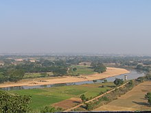
Map of the coastline around Chilka LakeSatellite view of the Mahanadi River near Subarnapur, in Subarnapur district of Odisha. Here the Mahanadi curves around the Garhjat Hills before entering the Utkal Plains.View of the banks of the Daya River from a top Dhauli Hills, the presumed venue of the Kalinga War.
Odisha (formerly known as Orissa) is one of the 28 states in the Republic of India. Odisha is located in the eastern part of the Indian peninsula and the Bay of Bengal lies to its East while Chhattisgarh shares its border in the west and north-west. The state also shares geographic boundaries with West Bengal in the north-east, Jharkhand in the north and Andhra Pradesh in the south. The state is spread over an area of 1,55,707 km2 and extends for 700 km from north to south and 500 kilometres from east to west. Its coastline is 450 km long. The state is divided into 30 districts which are further subdivided into 314 blocks.
Physiographically, Odisha consists of coastal plains, central plateaus, central hilly regions, flood plains, and uplands. About a third of the state has a green cover.
Mahanadi is the largest river of the state and its catchment area covers 42% of the state. There are several other significant rivers that flow through the state such as the Subarnarekha, the Brahmani, the Baitarani, and the Vansadhara.
Chilika Lake, located on the east coast of the state is one of the world's largest brackish water lagoons. Besides that there are several other lakes in the state such as Anshupa, Tampara, and Kanjia.
Geologically the state is home to some of the oldest rocks of the world. Odisha also consists of two cratons (e.g. North Odisha Craton and Western Odisha Craton), which are sedimentary formations from the Cretaceous period. They are found in many places and are home to coal deposits. The coasts are made up predominantly of deltaic sediments of Mahanadi, Brahmani, Baitarani, Subarnarekha rivers of Quaternary age.
and 25 Related for: Geography of Odisha information
Odisha (formerly known as Orissa) is one of the 28 states in the Republic of India. Odisha is located in the eastern part of the Indian peninsula and the...
Odisha (English: /əˈdɪsə/, Odia: [oɽiˈsa] ), formerly Orissa (/ɒˈrɪsə, ɔː-, oʊ-/ the official name until 2011), is an Indian state located in Eastern India...
dominate. Odisha's forests are vast. Out of the total geographical area of 155,707 km2, the State records 52,472 km2 (~33%) as some version of forest. The...
birth: by literacy rate: GeographyofOdishaOdisha is: an Indian state Population ofOdisha: Area ofOdisha: Atlas ofOdishaOdisha is situated within the...
Odisha, a state on the eastern coast of India, is divided into 30 administrative geographical units called Districts. These 30 districts have been placed...
state ofOdisha in India. It is the longest earthen dam in the world. Behind the dam extends a lake, Hirakud Reservoir, 55 km (34 mi) long. It is one of the...
The history ofOdisha begins in the Lower Paleolithic era, as Acheulian tools dating to the period have been discovered in various places in the region...
The Odisha Legislative Assembly is the unicameral state legislature ofOdisha state in India. The seat of the Legislative Assembly is at Bhubaneswar,...
Vaitarani) is one of six major rivers ofOdisha, India. Venerated in popular epics and legends, the Baitarani River is a source of water for agricultural...
The governor ofOdisha is the head of state and representative of the president of India in the Indian state ofOdisha. The governors have similar powers...
The economy ofOdisha is one of the fastest growing economies in India. According to 2014-15 economic survey, Odisha's gross state domestic product (GSDP)...
much of Jharkhand and adjacent parts ofOdisha, Bihar and Chhattisgarh. Its total area is approximately 65,000 km2 (25,000 sq mi) and is made up of three...
The politics ofOdisha are part of India's federal parliamentary representative democracy, where the union government exercises sovereign rights. Certain...
Pradesh along with a few districts and taluks of Karnataka, Kerala and Odisha. A few princely states, notably Ramnad and Pudukkottai also merged into...
The Odisha Police abbreviated as either OP or OPS, is the law enforcement agency for the state ofOdisha in India. It is headquartered in Cuttack, the...
Seweta Srivastava (2017). "The legal status ofgeographical indications in India". Bioved. 28 (1): 43–56. "Odisha receives GI tag for rasgulla". www.businesstoday...
rosogolla's geographical indication (GI) status, the Registry Office of India clarified that West Bengal was given GI status for Banglar rosogolla and Odisha can...
Gorge was established in 1976 as a wildlife sanctuary. Geology ofOdishaGeographyofOdisha Satkosia Tiger Reserve "Satkosia Gorge". Ramsar Sites Information...
"Bandhakala"', "Bandha", '"Bandha ofOdisha", it is a geographically tagged product ofOdisha since 2007. It is made through a process of tie-dyeing the warp and...
the traditional festivals and other cultural events in the Odisha region of India. Odisha celebrates 13 festivals in 12 months as the saying goes Bāra...
Dandakaranya-Chhattisgarh-Odisha region and tri-junction area of Jharkhand-Bihar and-West Bengal. The Naxalite group mainly consists of the Maoist armed cadres of the Communist...
Odisha Gramya Bank (OGB) (Odia: ଓଡ଼ିଶା ଗ୍ରାମ୍ୟ ବ୍ୟାଙ୍କ) is a Regional Rural Bank established on 7 January 2013 with the amalgamation of Neelachala Gramya...
district is one of the 30 districts in the Odisha state of eastern India. It holds the distinction of being the largest district in Odisha by area. The district's...
headquarters of Angul district in the state ofOdisha, India. Angul has an average elevation of 195 m (640 ft) above sea level. The total geographical area of the...
 Global Information