 Global Information
Geographic information system information
This article needs additional citations for verification. (March 2023) |
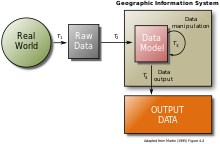
A geographic information system (GIS) consists of integrated computer hardware and software that store, manage, analyze, edit, output, and visualize geographic data.[1][2] Much of this often happens within a spatial database, however, this is not essential to meet the definition of a GIS.[1] In a broader sense, one may consider such a system also to include human users and support staff, procedures and workflows, the body of knowledge of relevant concepts and methods, and institutional organizations.
The uncounted plural, geographic information systems, also abbreviated GIS, is the most common term for the industry and profession concerned with these systems. It is roughly synonymous with geoinformatics. The academic discipline that studies these systems and their underlying geographic principles, may also be abbreviated as GIS, but the unambiguous GIScience is more common.[3] GIScience is often considered a subdiscipline of geography within the branch of technical geography.
Geographic information systems are utilized in multiple technologies, processes, techniques and methods. They are attached to various operations and numerous applications, that relate to: engineering, planning, management, transport/logistics, insurance, telecommunications, and business.[4] For this reason, GIS and location intelligence applications are at the foundation of location-enabled services, which rely on geographic analysis and visualization.
GIS provides the capability to relate previously unrelated information, through the use of location as the "key index variable". Locations and extents that are found in the Earth's spacetime are able to be recorded through the date and time of occurrence, along with x, y, and z coordinates; representing, longitude (x), latitude (y), and elevation (z). All Earth-based, spatial–temporal, location and extent references should be relatable to one another, and ultimately, to a "real" physical location or extent. This key characteristic of GIS has begun to open new avenues of scientific inquiry and studies.
- ^ a b DeMers, Michael (2009). Fundamentals of Geographic Information Systems (4th ed.). John Wiley & Sons, inc. ISBN 978-0-470-12906-7.
- ^ Chang, Kang-tsung (2016). Introduction to Geographic Information Systems (9th ed.). McGraw-Hill. p. 1. ISBN 978-1-259-92964-9.
- ^ Goodchild, Michael F (2010). "Twenty years of progress: GIScience in 2010". Journal of Spatial Information Science (1). doi:10.5311/JOSIS.2010.1.2.
- ^ Maliene V, Grigonis V, Palevičius V, Griffiths S (2011). "Geographic information system: Old principles with new capabilities". Urban Design International. 16 (1): 1–6. doi:10.1057/udi.2010.25. S2CID 110827951.