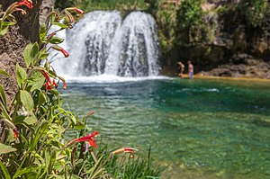
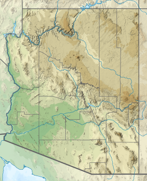
Fossil Creek (Yavapai: Hakhavsuwa or Vialnyucha) is a perennial stream accessed by forest roads near the community of Camp Verde in the U.S. state of Arizona. Primary access is from Forest Road 708 off Arizona State Route 260 east of Camp Verde. A tributary of the Verde River, Fossil Creek flows from its headwaters on the Mogollon Rim to meet the larger stream near the former Childs Power Plant.
Fossil Springs, near the headwaters, emits upwards of 20,000 US gallons (76 m3) per minute that flow into the creek year-round. Calcium carbonate, precipitating from the 72 °F (22 °C) water from the springs, creates travertine dams and deposits for several miles downstream. The Fossil Creek system is the fourth largest producer of travertine in the United States.
Fossil Creek is one of only two streams in Arizona included in the National Wild and Scenic Rivers System. The creek and its riparian corridor provide habitat for a wide variety of flora and fauna, some listed as endangered or otherwise imperiled. Its former power-plant complex is listed as a National Historic District. Since restoration of the stream's natural flow in 2008, an increase in recreational visits has raised concerns about overuse and has led to road closings and other restrictions.
^ abc"Fossil Creek". Geographic Names Information System. United States Geological Survey. February 8, 1980. Retrieved November 15, 2012.
^"Childs Irving Hydroelectric Project History". APS. Archived from the original on May 10, 2012. Retrieved November 18, 2012.
^Source elevation derived from Google Earth search using GNIS source coordinates.
^ abDuperrault 2003, pp. 10–13.
^Cite error: The named reference topoquest multiple quads was invoked but never defined (see the help page).
^ ab"Water-Data Report 2011: 09507480 Fossil Creek Near Strawberry, AZ" (PDF). U.S. Geological Survey. Retrieved November 20, 2012.
^ abSchlinger, Charlie (March 28, 2004). "Fossil Creek Gaging Station Alternatives Evaluation and Recommendations" (PDF). Northern Arizona University. Retrieved November 21, 2012.[permanent dead link]
Cite error: There are <ref group=n> tags on this page, but the references will not show without a {{reflist|group=n}} template (see the help page).
FossilCreek (Yavapai: Hakhavsuwa or Vialnyucha) is a perennial stream accessed by forest roads near the community of Camp Verde in the U.S. state of Arizona...
The Mazon Creekfossil beds are a conservation lagerstätte found near Morris, in Grundy County, Illinois. The fossils are preserved in ironstone concretions...
Cottonwood-Camp Verde-Pine road across FossilCreek. The road, also known as FossilCreek Road, crosses the creek at a point where it forms the border between...
morphological detail can be preserved. Nodules from the Carboniferous Mazon Creekfossil beds of Illinois, US, are among the best documented examples of such...
Skunk Creek Scatter Wash Salt River Arizona Canal Grand Canal (Phoenix) Verde River FossilCreek Oak Creek Granite Creek Pinto Creek Tonto Creek White...
dam on Caesar Creek to impound a 2,830-acre (1,150 ha) lake. The total park area, including the lake, is 7,530-acre (3,050 ha). Fossil collection is allowed...
National Monument is a small isolated section of the Hell Creek Formation. In 1966, the Hell CreekFossil Area was designated as a National Natural Landmark...
Oak Creek Canyon is a river gorge located in northern Arizona between the cities of Flagstaff and Sedona. The canyon is often described as a smaller cousin...
The FossilCreek Volcanics is a geologic formation in Alaska. It preserves fossils dating back to the Ordovician period. Earth sciences portal Alaska portal...
Havasu Creek is a stream in the U.S. state of Arizona associated with the Havasupai people. It is a tributary to the Colorado River, which it enters in...
This is an overview of the fossil flora and fauna of the Maastrichtian-Danian Hell Creek Formation. Insects from the groups Diptera, Zygoptera, and possibly...
Mazatzal Wilderness. The Wild portion extends from there to the mouth of Red Creek, about 22 miles (35 km) further downstream. In 1986, a 6-mile (10 km) stretch...
i.e., FossilCreek band"), lived in the upper Verde Valley, along the East Verde River, West Clear Creek, FossilCreek, and south to Cave Creek in central...
Verde River FossilCreek Gila River Haigler Creek Horton Creek Negro Wash Salome Creek Salt River Tonto Creek White River Workman Creek Graham County...
Dueling Dinosaurs or Montana Dueling Dinosaurs is a fossil specimen originating from the Hell Creek Formation of Montana. It consists of the fossilized...
in the San Francisco Peaks, along the Upper Verde River, Oak Creek Canyon, and FossilCreek overlapped with those of the Northern Tonto Apache. Likewise...
escarpment was created by erosion and faulting, creating canyons such as FossilCreek Canyon and Pine Canyon. The name Mogollon comes from Don Juan Ignacio...
Retrieved 2012-03-16. "USGS Gage #09432000 on the Gila River Below Blue Creek, Near Virden, NM" (PDF). National Water Information System. U.S. Geological...
Sonoita Creek is a tributary stream of the Santa Cruz River in Santa Cruz County, Arizona. It originates near and takes its name from the abandoned Pima...
than 100 species of birds. FossilCreek List of U.S. Wilderness Areas List of Arizona Wilderness Areas Wilderness Act Fossil Springs Wilderness Archived...
permit is required for any overnight visit. The Paria is essentially a large creek and is not navigable. A 2004 study estimated that the Tropic Ditch, a historic...
Names Information System, it has also been known historically as: Agua Fria Creek Agua Frie The Agua Fria River rises about 1.5 miles northeast of Granite...
 Global Information