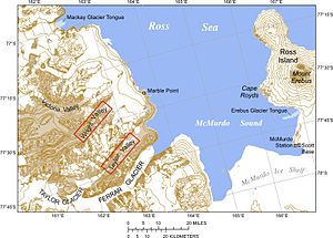
The Erebus Glacier Tongue extends into McMurdo Sound from Ross Island between Cape Royds and McMurdo Station.
The Erebus Glacier Tongue is a mountain outlet glacier and the seaward extension of Erebus Glacier from Ross Island. It projects 11 kilometres (6.8 mi) into McMurdo Sound from the Ross Island coastline near Cape Evans, Antarctica. The glacier tongue varies in thickness from 50 metres (160 ft) at the snout to 300 metres (980 ft) at the point where it is grounded on the shoreline.[1] Explorers from Robert F. Scott's Discovery Expedition (1901–1904) named and charted the glacier tongue.[2]
Erebus Glacier Tongue is about 10 metres (33 ft) high and is centred upon 77.6 degrees south latitude, 166.75 degrees east longitude.[3] The portion of the glacier tongue extending beyond the shoreline or grounding line floats upon the water.
Ice tongues emerge when a glacier ice stream flows rapidly (relative to surrounding ice) into the sea or a lake, usually in a protected area. For instance, Capes Evans and Royds extending from Ross Island protect the Erebus Glacier Tongue from the open waters of the Ross Sea. Hut Point Peninsula to the south helps deflect icebergs propelled by prevailing southerly winds.
The long, narrow Erebus ice stream drains from the western slope of Mount Erebus, an active volcano rising 3,794 metres (12,448 ft) in elevation. The mountain constantly replenishes the glacial ice stream, as annual snow fall exceeds annual snow melt. The Erebus Glacier Tongue is a dynamic structure subject to a host of internal and external stresses which affect its shape, size, and durability.[4]
^"Calving of Erebus Glacier Tongue, Nature Magazine. August 16, 1990.
^Australian Antarctic Data Centre Archived 2007-09-26 at the Wayback Machine, Antarctic Gazetteer Name Details.
^“Erebus Ice Tongue,” Archived 2011-05-15 at the Wayback Machine NASA Jet Propulsion Laboratory, California Institute of Technology. Undated.
^Pyne, Stephen J. The Ice: A Journey to Antarctica. Originally published by the University of Iowa Press, 1986.
and 25 Related for: Erebus Glacier Tongue information
The ErebusGlacierTongue is a mountain outlet glacier and the seaward extension of ErebusGlacier from Ross Island. It projects 11 kilometres (6.8 mi)...
lake at the summit of Mount ErebusErebusglaciertongue A panoramic view from the summit of Mount Erebus Video of Mount Erebus erupting in 2005 List of...
Erebus Bay (77°44′S 166°31′E / 77.733°S 166.517°E / -77.733; 166.517 (Erebus Bay)) is a bay about 13 nautical miles (24 km; 15 mi) wide between Cape...
Antarctica. It flows west to Erebus Bay where it forms the floating ErebusGlacierTongue. It was named in association with Mount Erebus by the British National...
Glacier, Terror Glacier and Aurora Glacier. ErebusGlacier is a glacier draining the lower southern slopes of Mount Erebus. It flows west to Erebus Bay...
The Drygalski Ice Tongue, Drygalski Barrier, or Drygalski GlacierTongue is a glacier in Antarctica, on the Scott Coast, in the northern McMurdo Sound...
Antarctic Expedition(1901–04) led by Robert Falcon Scott. Glacier Ice Tongues – The ErebusGlacierTongue projects 11–12 kilometres (6.8–7.5 mi) from the coastline...
had equipment mounted on the ErebusGlacierTongue when it calved in 1990. He had just finished a field trip to the glacier in 2010 when it next calved...
Oakley Glacier enters from the north, beside the Icebreaker Glacier and the Fitzgerald Glacier, which form a common tongue. The Finley Glacier and Dunn...
ships, the Erebus. Alberts 1995, p. 306. Riffenburgh 2007, p. 639. "K/Ar and Rb/Sr dating of McMurdo Volcanic Group (north of Campbell Glacier)" (PDF)....
1841, who named it for Alexander J. Smith, mate on the Erebus. Alberts 1995, p. 46. Ebbe Glacier USGS. Yule Bay USGS. Alberts 1995, p. 197. Alberts 1995...
he was driving broke through bay ice and sank in the vicinity of ErebusGlacierTongue and Turtle Rock. 77°26′S 160°57′E / 77.433°S 160.950°E / -77...
HMS Erebus. Wood Bay is on the west coast of the Ross Sea. It is delimited to the north by Hayes Head on Cape Johnson. The Aviator GlacierTongue extends...
Magnetic Pole, and the expedition also achieved the first ascent of Mount Erebus, Antarctica's second highest volcano. The expedition lacked governmental...
limit. Only after the Aurora—heading west—had rounded the ice tongue of the Mertz Glacier, was a landing made. Battling katabatic winds that swept down...
the pole in exploration history. Also, members of his team climbed Mount Erebus, the most active Antarctic volcano. On returning home, Shackleton was knighted...
always been present off the coast of Greenland, but was covered by a glacier. This glacier was discovered in 2002 to be shrinking rapidly, and by 2007 had...
Shackleton had crossed the Great Ice Barrier, discovered the Beardmore Glacier route to the Polar Plateau, and had struck out for the Pole. He had been...
Mount Erebus, Ross Island The area was the site of an Air New Zealand aircraft crash on 28 November 1979 into the northern slope of Mount Erebus. The designated...
commanding 128 men in two robust and well-stocked Royal Navy ships, the Erebus and Terror. They were never heard from again. Eventually, searchers found...
Christmas Day as they camped on a glaciertongue, unaware that Mawson and Mertz were camped in the upper reaches of the same glacier. After completing a full coastal...
with Shackleton's instructions not to attempt to anchor south of the GlacierTongue, an icy protrusion midway between Cape Evans and Hut Point. This search...
and astronomical research. The expedition charted and named Français GlacierTongue, Ionosphere Bay and Parasite Bay, among others. In 1950–1952, Michel...
desperate dash over the moving ice floes, they managed to reach a small glaciertongue. Mackintosh later wrote about the near-death experience: "Our luck was...
 Global Information