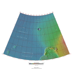
Map of Diacria quadrangle from Mars Orbiter Laser Altimeter (MOLA) data. The highest elevations are red and the lowest are blue.
Coordinates
47°30′N150°00′W / 47.5°N 150°W / 47.5; -150
Eponym
Diacria highlands around Marathon in Greece
Image of the Diacria Quadrangle (MC-2). The southeastern part is marked by aureole deposits of the largest known volcano in the Solar System, Olympus Mons.
The Diacria quadrangle is one of a series of 30 quadrangle maps of Mars used by the United States Geological Survey (USGS) Astrogeology Research Program. The quadrangle is located in the northwestern portion of Mars' western hemisphere and covers 180° to 240° east longitude (120° to 180° west longitude) and 30° to 65° north latitude. The quadrangle uses a Lambert conformal conic projection at a nominal scale of 1:5,000,000 (1:5M). The Diacria quadrangle is also referred to as MC-2 (Mars Chart-2).[1] The Diacria quadrangle covers parts of Arcadia Planitia and Amazonis Planitia.
The southern and northern borders of the Diacria quadrangle are approximately 3,065 km (1,905 mi) and 1,500 km (930 mi) wide, respectively. The north to south distance is about 2,050 km (1,270 mi) (slightly less than the length of Greenland).[2] The quadrangle covers an approximate area of 4.9 million square km, or a little over 3% of Mars' surface area.[3] The Phoenix lander's landing site (68.22° N, 234.25° E) lies about 186 km (116 mi) north of the northeastern quarter of the Diacria quadrangle. The landscape viewed by the Phoenix lander is probably representative of a large portion of the terrain in the northern Diacria quadrangle.
^Davies, M.E.; Batson, R.M.; Wu, S.S.C. "Geodesy and Cartography" in Kieffer, H.H.; Jakosky, B.M.; Snyder, C.W.; Matthews, M.S., Eds. Mars. University of Arizona Press: Tucson, 1992.
^Distances calculated using NASA World Wind measuring tool. "NASA WorldWind".
^Approximated by integrating latitudinal strips with area of R^2 (L1-L2)(cos(A)dA) from 30° to 65° latitude; where R = 3889 km, A is latitude, and angles expressed in radians. See: "Calculating area enclosed by arbitrary polygon on Earth's surface - Stack Overflow".
and 28 Related for: Diacria quadrangle information
The Diacriaquadrangle is one of a series of 30 quadrangle maps of Mars used by the United States Geological Survey (USGS) Astrogeology Research Program...
after the classical Diacria. This was later adopted in the official name of the Diacriaquadrangle, one of the cartographic quadrangles of the Martian atlas...
streaks and layers. Tikhonravov Crater is in the Arabia quadrangle. Dark streaks in Diacriaquadrangle, as seen by Mars Global Surveyor, under the MOC Public...
Erebus Montes is a group of mountains in the Diacriaquadrangle of Mars, located at 35.66° North and 185.02° West. It is 811 km across and was named after...
Cebrenia quadrangle. These locations are 55.57° N, 150.62° E; 43.28° N, 176.9° E; and 45° N, 164.5° E. Two others are in the Diacriaquadrangle: 46.7° N...
The Hellas quadrangle is one of a series of 30 quadrangle maps of Mars used by the United States Geological Survey (USGS) Astrogeology Research Program...
47; 250.4 in the Arcadia quadrangle (MC-3). Much of the volcano's western flank is located in the adjacent Diacriaquadrangle (MC-2). Flows from the volcano...
Arabia quadrangle. Click on image to see dark slope streaks and layers. Dark streaks in Diacriaquadrangle. Dark Streaks in Arabia quadrangle. Crater...
has been divided into thirty cartographic quadrangles by the United States Geological Survey. Each quadrangle is a region covering a specified range of...
45°00′N 164°30′E / 45°N 164.5°E / 45; 164.5. Two others are in the Diacriaquadrangle: 46°42′N 176°48′E / 46.7°N 176.8°E / 46.7; 176.8 and 46°20′N 176°54′E...
The Phaethontis quadrangle is one of a series of 30 quadrangle maps of Mars used by the United States Geological Survey (USGS) Astrogeology Research Program...
Cyane Fossae is a trough in the Diacriaquadrangle of Mars. It is centered at 31.3° north latitude and 121.2° west longitude. It is 913 kilometres (567 mi)...
The Coprates quadrangle is one of a series of 30 quadrangle maps of Mars used by the United States Geological Survey (USGS) Astrogeology Research Program...
The Iapygia quadrangle is one of a series of 30 quadrangle maps of Mars used by the United States Geological Survey (USGS) Astrogeology Research Program...
Dia /ˈdaɪə/ An island north of Crete Diacria /daɪˈeɪkriə/ Diacria highlands around Marathon Diacriaquadrangle Dioscuria /ˌdaɪəsˈkjʊəriə/ "Land of the...
slope streak, as seen by HiRISE under HiWish program. Dark streaks in Diacriaquadrangle, as seen by Mars Global Surveyor. Layers and dark slope streaks, as...
The Mare Boreum quadrangle is one of a series of 30 quadrangle maps of Mars used by the United States Geological Survey (USGS) Astrogeology Research Program...
165.9–210.4° East, straddling partly in the Cebrenia quadrangle (MC-07), and partly in the Diacria one (MC-02), and centered at 47°12′N 184°18′E / 47...
The Casius quadrangle is one of a series of 30 quadrangle maps of Mars used by the United States Geological Survey (USGS) Astrogeology Research Program...
The Aeolis quadrangle is one of a series of 30 quadrangle maps of Mars used by the United States Geological Survey (USGS) Astrogeology Research Program...
based on Schorghofer et al., 2007, p. 136, Fig. 5. C. Dark streaks in Diacriaquadrangle, as seen by the Mars Orbiter Camera (MOC) on Mars Global Surveyor...
The Lunae Palus quadrangle is one of a series of 30 quadrangle maps of Mars used by the United States Geological Survey (USGS) Astrogeology Research Program...
Gullies on wall of mesa, as seen by HiRISE under HiWish program Diacriaquadrangle gullies Wide view of group of gullies, as seen by HiRISE under HiWish...
The Margaritifer Sinus quadrangle is one of a series of 30 quadrangle maps of Mars used by the United States Geological Survey (USGS) Astrogeology Research...
Acheron Fossae is a trough in the Diacriaquadrangle of Mars. Its location is centered at 37.67° north latitude and 135.87° west longitude. It is 718 km...
The Tharsis quadrangle is one of a series of 30 quadrangle maps of Mars used by the United States Geological Survey (USGS) Astrogeology Research Program...
The Sinus Sabaeus quadrangle is one of a series of 30 quadrangle maps of Mars used by the United States Geological Survey (USGS) Astrogeology Research...
 Global Information