Map of Coprates quadrangle from Mars Orbiter Laser Altimeter (MOLA) data. The highest elevations are red and the lowest are blue.
Coordinates
15°00′S67°30′W / 15°S 67.5°W / -15; -67.5
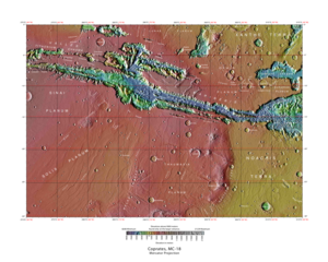
Image of the Coprates Quadrangle (MC-18). The prominent Valles Marineris chasma system intersects the moderately cratered northern part and the faulted highland ridged plains in the southern part.
The Coprates quadrangle is one of a series of 30 quadrangle maps of Mars used by the United States Geological Survey (USGS) Astrogeology Research Program. The Coprates quadrangle is also referred to as MC-18 (Mars Chart-18).[1] The Coprates quadrangle contains parts of many of the old classical regions of Mars: Sinai Planum, Solis Planum, Thaumasia Planum, Lunae Planum, Noachis Terra, and Xanthe Terra.
The name Coprates refers to Coprates Chasma, a central trough of the Valles Marineris, named after the Greek name of the Dez River in Persia.[2]
The Coprates quadrangle goes from 45° to 90° west longitude and 0° to 30° south latitude on Mars. Coprates quadrangle is famous for depicting the "Grand Canyon of Mars", the Valles Marineris Canyon System. Signs of water exist in this quadrangle, with ancient river valleys and networks of stream channels showing up as inverted terrain and lakes inside of Valles Marineris.[3]
^Davies, M.E.; Batson, R.M.; Wu, S.S.C. "Geodesy and Cartography" in Kieffer, H.H.; Jakosky, B.M.; Snyder, C.W.; Matthews, M.S., Eds. Mars. University of Arizona Press: Tucson, 1992.
^Blunck, J. 1982. Mars and its Satellites. Exposition Press. Smithtown, N.Y.
^Cabrol, N. and E. Grin (eds.). 2010. Lakes on Mars. Elsevier. NY
and 27 Related for: Coprates quadrangle information
The Copratesquadrangle is one of a series of 30 quadrangle maps of Mars used by the United States Geological Survey (USGS) Astrogeology Research Program...
20 miles wide. Image is in Copratesquadrangle. Branching channels on floor of Melas Chasma. Image is in Copratesquadrangle. Labeatis Fossae, as seen...
Tithonium Chasma is a large canyon in the Copratesquadrangle of Mars at 4.6° south latitude and 84.7° west longitude. It is about 810 km long and was...
Coprates Chasma (/ˈkɒprətiːz ˈkæzmə/) is a huge canyon in the Copratesquadrangle of Mars, located at 13.4° south latitude and 61.4° west longitude, part...
Ophir Chasma /ˈoʊfər ˈkæzmə/ is a canyon in the Copratesquadrangle of Mars at 4° south latitude and 72.5° west longitude. It is about 317 km long and...
Ius Chasma is a large canyon in the Copratesquadrangle of Mars at 7° south latitude and 85.8° west longitude. It is about 938 km long and was named after...
Capri Mensa is a mesa in the Copratesquadrangle of Mars at 14° south latitude and 47.4° west longitude. It is about 275 km long and was named after a...
It is in the Lunae Palus quadrangle, the Copratesquadrangle, the Margaritifer Sinus quadrangle, and the Oxia Palus quadrangle. Ravi Vallis, Aromatum Chaos...
Global Surveyor on 10 August 1999. Layers in the canyon wall in Copratesquadrangle, as seen by Mars Global Surveyor, under MOC Public Targeting Program...
Eos Chaos is a rough, collapsed area in the Copratesquadrangle on Mars at 16.8° south latitude and 46.9° west longitude. It is about 490 km long and...
be found there because the deposits are relatively young. Map of Copratesquadrangle showing details of Valles Marineris, the largest canyon system in...
channels. Image in Copratesquadrangle. Scale bar is 500 meters long. Inverted Channel with many branches in Syrtis Major quadrangle. Inverted Stream Channels...
Location is Noachis quadrangle. Ophir Chasma Wall. Location is Copratesquadrangle. Tithonium Chasma. Location is Copratesquadrangle. Layers west of Juventae...
parts of the canyon system contained lakes. It is located in the Copratesquadrangle. The walls of the canyons often contain many layers. The floors of...
Location is Memnonia quadrangle. Ophir Chasma Wall. Location is Copratesquadrangle. Tithonium Chasma. Location is Copratesquadrangle. Layers west of Juventae...
Marineris system on Mars, an offshoot of Capri Chasma, and is in the Copratesquadrangle. It is named after the River Ganges in South Asia. Ganges Chasma...
of the Valles Marineris canyon system of the Copratesquadrangle and the Margaritifer Sinus quadrangles of the planet Mars. Eos Chasma’s western floor...
surface. Image is in Copratesquadrangle. Dendritic channels on mesa of Echus Chasma. Image is 20 miles wide. Image is in Copratesquadrangle. Branching channels...
The Calydon fossa is the valley in Valles Marineris on Mars. It is situated at 7°S 88°W. The fossa runs parallel to the equator and has width varying from...
Marineris canyon system, located east of Ius Chasma at 9.8°S, 283.6°E in Copratesquadrangle. It cuts through layered deposits that are thought to be sediments...
Her Desher Vallis is an ancient river valley in the Copratesquadrangle of Mars, located at 25.4° S and 48.0° W. It is 107.0 km across and was named for...
approved in 1973. Edge of lava flow, as seen by HiRISE under HiWish program "Planetary Names: Search Results". Phoenicis Lacus quadrangle Volcanism on Mars...
The Tharsis quadrangle is one of a series of 30 quadrangle maps of Mars used by the United States Geological Survey (USGS) Astrogeology Research Program...
Eridania Lake Iani Chaos Olympia Undae Planum Australe Planum Boreum Quadrangles Sinus Meridiani Tempe Terra Terra Cimmeria Terra Sabaea Tharsis Undae...
north of the Valles Marineris canyon system of Mars. It is in the Copratesquadrangle. Clay has been found within it, meaning that water once sat there...
wrinkle ridge, as seen by HiRISE under HiWish program. Location in the Copratesquadrangle, Mars. Wrinkle ridge in the Oxia Colles region of Mars Antoniadi...
Valles. Juventae Chasma is located north of Valles Marineris in the Copratesquadrangle and cuts more than 5 km into the plains of Lunae Planum. Juventae...
 Global Information