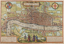
Detail from the Copperplate map showing St Paul's CathedralBraun and Hogenberg's map of London (published 1572), showing the likely extent of the area originally covered by the full Copperplate map
The "Copperplate" map of London is an early large-scale printed map of the City of London and its immediate environs, surveyed between 1553 and 1559, which survives only in part. It is the earliest true map of London (as opposed to panoramic views, such as those of Anton van den Wyngaerde). The original map was probably designed for hanging on a wall, and is believed to have measured approximately 3 feet 8 inches (112 cm) high by 7 feet 5 inches (226 cm) wide.[1] No copies of the printed map itself are known to have survived; but between 1962 and 1997 three of the original engraved copper printing-plates – from a probable total of 15 – were identified. Although only a fragmentary portion of the map is known, the three plates cover the greater part of the built-up heart of the City of London.
The map takes the form of a "bird's-flight view": that is to say, the street layout and other ground features are shown in plan, as if viewed directly from above; while buildings, people and other standing features are shown as if viewed from a great height to the south of the City, but without the foreshortening of more distant features that would be necessary for a true perspective view.
The map is clearly the source for the slightly smaller-scale and cruder "Woodcut" map, formerly attributed to Ralph Agas, which dates from shortly after 1561; and also, directly or indirectly, for the greatly reduced map of London included in Georg Braun and Frans Hogenberg's Civitates Orbis Terrarum, published in Cologne and Amsterdam in 1572. These two derivative maps allow the original extent and size of the Copperplate map to be estimated.
^Marks 1964, p. 14
and 23 Related for: Copperplate map of London information
The "Copperplate" mapofLondon is an early large-scale printed mapof the City ofLondon and its immediate environs, surveyed between 1553 and 1559, which...
fractionally larger. The Woodcut map is a slightly smaller-scale, cruder and lightly modified copy of the so-called "Copperplate" map, surveyed between 1553 and...
position on the "Copperplate" mapofLondon, dating to the 1550s, and on the derivative "Woodcut" mapof the 1560s. It was described by the London historian...
Drake–Norris Expedition of 1589. Three further Spanish Armadas also failed in 1596, 1597 and 1602. The war ended with the Treaty ofLondon the year following...
charity. Bishopsgate and the extramural part of Bishopsgate Street, as shown on the "Copperplate" mapofLondonof the 1550s The bishop's mitre at Bishopsgate's...
ac.uk/survey-london/vol47/pp22-51 [accessed 2 August 2020]. The History of the River Fleet, UCL Fleet Restoration Team, 2009 From a map based on Stow...
Pleasaunte Treatyse. London. "'Copperplate' MapofLondon". 1553. Retrieved 2024-04-06. Hill, Thomas (1577). The Gardeners Labyrinth. London: Published under...
Palace in London was built as a residence of King Henry VIII and was one of his homes early in his reign for eight years. Given to the City ofLondon Corporation...
central London which includes a six-rink grass bowling green. It was developed in 1777 on the site of a previous area of green space to the north of the City...
City ofLondon, lying adjacent to – and outside – its northern wall, near the eponymous Moorgate. It was known for its marshy conditions, the result of the...
centimetres (111 in), and consisted of six individual panels. From the middle of the 16th century, the copperplate process, originating in Antwerp, began...
contemporary sources of information on his life, including copperplates from his vassal Madhavavarma (king of Ganjam), copperplatesof his rivals Harsha...
Fish Street was a church in Castle Baynard ward of the City ofLondon, England, located on the corner of Old Fish Street and Old Change, on land now covered...
It was created to accommodate the ever-increasing number of new interments required as London's population expanded during 16th to 18th centuries. It was...
000 copperplatesof Janssonius and Blaeu found their way to other publishers. Historian David Buisseret has traced the roots of the flourishing of cartography...
covered over. By the time of the first mapsof the area, the "copperplate" mapof the 1550s and the derivative "Woodcut" mapof c. 1561, the whole Walbrook...
Geminus for a London edition published in 1555. It has also been suggested that Lily had a hand in the large-scale "CopperplateMap" ofLondon, printed in...
proposed that the map accompanying the text was even older than Pseudo-Richard's text. His letters state that he bought a copperplate to engrave it himself...
artist and copperplate engraver working from Augsburg. Leizelt produced a series of European and American scenic views at a time when pictures of foreign...
sustained: the Woodcut map is now dated to the early 1560s, and is known to be based on the slightly earlier "Copperplate" mapof the 1550s, making it highly...
Pushyavarman first appear in the 7th century, in Dubi and Nidhanpur copperplate inscriptions issued by Bhaskaravarman and in the Harshacharita and not...
Bipenninum Flore Carnco Hand-colored copperplate engraving". www.theantiquarium.com. Retrieved Mar 24, 2020. Gallery of Abraham Munting prints Paintings Guide...
of so far discovered copperplate inscriptions of the Vakataka dynasty (in all 17) pertain to Pravarasena II. He is perhaps the most recorded ruler of...
 Global Information