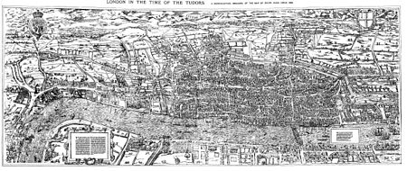
The Woodcut map of London, from the reproduction of 1874
The "Woodcut" map of London, formally titled Civitas Londinum, and often referred to as the "Agas" map of London, is one of the earliest true maps (as opposed to panoramic views, such as those of Anton van den Wyngaerde) of the City of London and its environs. The original map probably dated from the early 1560s, but it survives only in later and slightly modified copies. It was printed from woodcut blocks on eight sheets, and in its present state measures approximately 2 feet 4 inches (71 cm) high by 6 feet (180 cm) wide. There has been some damage to the blocks, and it was probably originally fractionally larger.[1]
The Woodcut map is a slightly smaller-scale, cruder and lightly modified copy of the so-called "Copperplate" map, surveyed between 1553 and 1559, which, however, survives only in part. It also bears a close resemblance to the map of London included in Georg Braun and Frans Hogenberg's Civitates Orbis Terrarum, published in Cologne and Amsterdam in 1572, although this is on a greatly reduced scale.[2]
The Woodcut map was traditionally attributed to the surveyor and cartographer Ralph Agas, but this attribution is now considered to be erroneous.
^Marks 1964, p. 15
^Reproduced in Prockter, Taylor & Fisher 1979, p. 32
and 21 Related for: Woodcut map of London information
City of London Corporation Interactive maps (Electoral services: Ward boundaries) "Gardens of the City ofLondon". Gardens of the City ofLondon. Archived...
is shown in a series of detailed maps, particularly John Rocque's 1741–45 map (see below) and his 1746 MapofLondon. New districts such as Mayfair were...
The Great Plague ofLondon, lasting from 1665 to 1666, was the last major epidemic of the bubonic plague to occur in England. It happened within the centuries-long...
the "Copperplate" mapofLondon, dating to the 1550s, and on the derivative "Woodcut" mapof the 1560s. It was described by the London historian John Stow...
local brick earth deposits. The street featured in the 16th-century WoodcutmapofLondon as a partially developed crossroad leading north from the city's...
function. On old maps, such as the "Woodcut" mapofLondonof the early 1560s, the Mews can be seen extending back towards the site of today's Leicester...
corner of the SE1 postcode district. The "Woodcut" mapofLondonof c. 1561 calls the general area "Horssey Down". The 1872 Ordnance Survey 1:2500 map calls...
In 1563, London experienced its worst episode of plague during the sixteenth century. At least 20,136 people in London and surrounding parishes were recorded...
woodcuts, an increasingly common process from 1500 onwards was the creation of prints from huge woodcuts and woodblocks. Jacopo de' Barbari's mapof Venice...
Peter Martyr map is a Spanish woodcutmap composed in 1511 or 1514 and included in most or some copies of the 1511 edition of Decades of the New World...
printed star chart, a 1515 set ofwoodcut portraits produced by Albrecht Dürer in Nuremberg, Germany. During the European Age of Discovery, expeditions to...
of Antwerp promoted its present name in 1613. The earliest surviving maps on the projection appear as crude woodcut drawings of terrestrial globes of...
Fantasy cartography, fictional map-making, or geofiction is a type ofmap design that visually presents an imaginary world or concept, or represents a...
of nationalities. Mapsof the Enlightenment period practically universally used copper plate intaglio, having abandoned the fragile, coarse woodcut technology...
the area surrounding the Tower ofLondon in the London Borough of Tower Hamlets. It is infamous for the public execution of high status prisoners from the...
generation to generation. The "Woodcut" mapofLondonof c.1561 shows the site of No.80 Coleman Street occupied by some part of two small houses immediately...
Essex. Of those windmills known to have existed, nine remain and are preserved; as are the tide mills at Three Mills, West Ham. c.1563 "Woodcut" (or "Agas")...
Survey ofLondon, vol. 5 The Parish of St. Giles-in-the-Fields part II, London County Council, p. 3 Claire Tomalin (12 December 2014), "My London: Lincoln's...
 Global Information