"CO 7" redirects here. For the congressional district, see Colorado's 7th congressional district.
State Highway 7
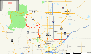
Map of northern Colorado with SH 7 highlighted in red
Route information
Maintained by CDOT
Length
81.64 mi[1] (131.39 km)
Major junctions
West end
US 36 in Estes Park
Major intersections
US 36 in Lyons and in Boulder
I-25 / US 87 in Broomfield
East end
I-76 / US 6 in Brighton
Location
Country
United States
State
Colorado
Counties
Larimer, Boulder, Weld, Broomfield, Adams
Highway system
Colorado State Highway System
Interstate
US
State
Scenic
← US 6
→ SH 8
State Highway 7 (SH 7) is an 81.64-mile (131.39 km) state highway in Colorado, United States. It is located in the north-central portion of the state, traversing the mountains on the east of the continental divide south of Estes Park as well as portions of the Colorado Piedmont north of Denver. The northwestern segment of the highway is part of the Peak to Peak Scenic Byway and furnishes an access route to Estes Park, Colorado and Rocky Mountain National Park. In its southeast portion it skirts the northern end of the Denver Metropolitan Area, providing an access route connecting Boulder, Lafayette and Brighton with Interstate 25 (I-25) and Interstate 76 (I-76).
The western terminus is at the junction of U.S. Route 36 at North St. Vrain and South St. Vrain avenues in Estes Park. The eastern terminus is at I-76 exit 25 in Brighton. The portion between Lyons and Boulder, where it is concurrent with US 36, is unsigned. The highway is two lanes along the entire route except for portions in the cities and towns.
^"Segment list for SH 7". Retrieved 2007-05-12.[permanent dead link]
and 24 Related for: Colorado State Highway 7 information
The statehighways of Colorado are a system of public paved roads funded and maintained by the Colorado Department of Transportation (CDOT) in the U.S...
StateHighway 82 (SH 82) is an 85.3-mile-long (137.3 km) statehighway in the U.S. state of Colorado. Its western half provides the principal transportation...
StateHighway 12 (SH 12), also known as the Highway of Legends National Scenic Byway, in the U.S. state of Colorado is a mountainous statehighway through...
Colorado Department of Transportation (CDOT), an agency responsible for building and maintaining statehighways, US highways, and Interstate highways...
the US state of Colorado, Interstate 25 (I-25) follows the north–south corridor through Colorado Springs and Denver. The highway enters the state from the...
StateHighway 66 (SH 66) is a 22.7 mi (36.5 km) long east-west statehighway in Boulder and Weld counties in Colorado. The highway extends from the foothills...
StateHighway 2 (SH 2) is a statehighway of the U.S. state of Colorado. It runs for approximately 20 miles (32 km) north–south entirely within the urbanized...
Template:Attached KML/ColoradoStateHighway 72 KML is from Wikidata Official website Colorado Department of Transportation (CDOT): Colorado Scenic Byways -...
The ColoradoState Patrol (CSP) (originally known as the ColoradoStateHighway Courtesy Patrol), based in Lakewood, Colorado, is a division of the Colorado...
StateHighway 21 (SH 21), also known as Powers Boulevard, is an expressway in El Paso County, in eastern Colorado Springs. SH 21 currently extends from...
StateHighway 119 (SH 119) is a 63.7-mile-long (102.5 km) statehighway in north central Colorado. It extends in a southwest to northeast direction, from...
StateHighway 121 (SH 121) is a 30.425 mile (48.96 km) long statehighway in the U.S. state of Colorado. SH 121's southern terminus is at Waterton Road...
traverses an east–west route across the center of the state. In western Colorado, the highway connects the metropolitan areas of Grand Junction and Denver...
StateHighway 93 (SH 93) is a statehighway in Colorado that connects Golden and Boulder. SH 93's southern terminus is at U.S. Route 6 (US 6) and SH 58...
Colorado (/ˌkɒləˈrædoʊ, -ˈrɑːdoʊ/ KOL-ə-RAD-oh, -RAH-doh, other variants) is a landlocked state in the Mountain West subregion of the Western United States...
StateHighway 115 (SH 115) is a statehighway in the U.S. state of Colorado. SH 115's southern terminus is at U.S. Route 50 (US 50) interchange in northern...
by the state of Colorado, totaling about 956 miles (1,539 km). Colorado has three main highways (two-digit routes), and two auxiliary highways (three-digit...
StateHighway 94 (SH 94) is an 85.5-mile-long (137.6 km) east–west Coloradostatehighway that goes east beginning from US 24 just east of Colorado Springs...
 Global Information