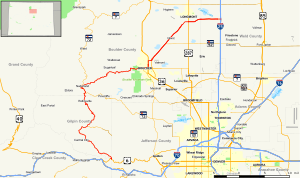
Map of north central Colorado with SH 119 highlighted in red
Route information
Maintained by CDOT
Length
63.7 mi[1] (102.5 km)
Major junctions
South end
US 6 in Clear Creek Canyon west of Golden
Major intersections
SH 72 in Nederland
US 36 / SH 7 in Boulder
SH 52 in Niwot
US 287 in Longmont
North end
I-25 / US 87 east of Longmont
Location
Country
United States
State
Colorado
Counties
Jefferson, Gilpin, Boulder, Weld
Highway system
Colorado State Highway System
Interstate
US
State
Scenic
← SH 116
→ SH 120
State Highway 119 (SH 119) is a 63.7-mile-long (102.5 km) state highway in north central Colorado. It extends in a southwest to northeast direction, from a junction with U.S. Route 6 (US 6) in Clear Creek Canyon between Golden and Idaho Springs to a junction with Interstate 25 (I-25) east of Longmont.
The southwest portion of the road is a scenic mountain drive providing dramatic vistas of the Front Range, while the northeast portion is a busy interurban thoroughfare. The city of Boulder separates these two vastly different sections of SH 119.
^"Segment list for SH 119". Retrieved 2011-01-20.[permanent dead link]
and 22 Related for: Colorado State Highway 119 information
StateHighway119 (SH 119) is a 63.7-mile-long (102.5 km) statehighway in north central Colorado. It extends in a southwest to northeast direction, from...
StateHighway 93 (SH 93) is a statehighway in Colorado that connects Golden and Boulder. SH 93's southern terminus is at U.S. Route 6 (US 6) and SH 58...
The statehighways of Colorado are a system of public paved roads funded and maintained by the Colorado Department of Transportation (CDOT) in the U.S...
StateHighway 52 (SH 52) is a 111 mi (178.6 km) long statehighway in northeastern Colorado. The western terminus is at SH 119 near Niwot, and the eastern...
Template:Attached KML/ColoradoStateHighway 72 KML is from Wikidata Official website Colorado Department of Transportation (CDOT): Colorado Scenic Byways -...
California State Route 119ColoradoStateHighway119 Florida State Road 119 (former) County Road 119 (Duval County, Florida) Georgia State Route 119 Illinois...
the US state of Colorado, Interstate 25 (I-25) follows the north–south corridor through Colorado Springs and Denver. The highway enters the state from the...
StateHighway 115 (SH 115) is a statehighway in the U.S. state of Colorado. SH 115's southern terminus is at U.S. Route 50 (US 50) interchange in northern...
StateHighway 157 (SH 157) is a 4.530-mile-long (7.3 km) statehighway in Boulder, Colorado. SH 157 is also known as Foothills Parkway in Boulder's city...
StateHighway 103 (SH 103) in the U.S. state of Colorado runs from Interstate 70 (I-70), U.S. Route 6 (US 6) and US 40 at Idaho Springs to county roads...
StateHighway 64 (SH 64) is a 74-mile-long (119 km) two-lane statehighway connecting the towns of Dinosaur and Meeker in the western part of the U.S....
StateHighway 114 (SH 114) is a 61.7 mi (99.3 km) long statehighway in southern central Colorado. SH 114's western terminus is at U.S. Route 50 (US 50)...
StateHighway 109 (SH 109) is a 65.327 mi (105.134 km) long statehighway in southeastern Colorado. SH 109's southern terminus is at U.S. Route 160 (US...
the state is assigned a number, officially StateHighway No. X but also commonly referred to as Nebraska Highway X, as well as N-X. Statehighways are...
StateHighway 116 (SH 116) is a fairly isolated statehighway in Colorado that runs from the Kansas state line in the south eastern corner of the state...
StateHighway 113 (SH 113) is an 18.8-mile-long (30.3 km) statehighway in northeastern Colorado. It runs from U.S. Highway 138 (US 138) in rural Logan...
StateHighway 110 (SH 110) is a statehighway in Silverton, Colorado. SH 110's western terminus is at U.S. Route 550 (US 550) in Silverton, and the eastern...
traverses an east–west route across the center of the state. In western Colorado, the highway connects the metropolitan areas of Grand Junction and Denver...
 Global Information