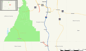
Map of central Colorado with SH 105 highlighted in red
Route information
Maintained by CDOT
Length
9.238 mi[1] (14.867 km)
Major junctions
South end
CR 105 / Jackson Creek Parkway near Monument
Major intersections
I-25 / US 85 / US 87 in Monument
North end
SH 67 near Sedalia
Location
Country
United States
State
Colorado
Counties
El Paso, Douglas
Highway system
Colorado State Highway System
Interstate
US
State
Scenic
← SH 103
→ SH 109
State Highway 105 (SH 105) is a state highway that runs partially from I-25 in Monument to SH 67 (Manhart Avenue) in Sedalia. The highway serves the communities of Monument and Palmer Lake and the unincorporated areas of Douglas and El Paso counties. Several former sections have been deleted from the state highway system since its inception, thus leading to north and south sections of the current highway.
^"SH 105 Inventory Form" (PDF). Colorado Department of Transportation. Retrieved January 22, 2022.
and 15 Related for: Colorado State Highway 105 information
StateHighway105 (SH 105) is a statehighway that runs partially from I-25 in Monument to SH 67 (Manhart Avenue) in Sedalia. The highway serves the communities...
The statehighways of Colorado are a system of public paved roads funded and maintained by the Colorado Department of Transportation (CDOT) in the U.S...
StateHighway 67 (SH 67) is a 71-mile-long (114 km) statehighway encompassing five distinct segments in south-central Colorado. SH 67's southern terminus...
This is a list of the state parks in the U.S. State of Colorado. Colorado Parks and Wildlife manages the state park system to accommodate both outdoor...
Alabama State Route 105 Arkansas Highway105ColoradoStateHighway105 Florida State Road 105 Georgia State Route 105 Georgia State Route 105 (1932–1937)...
Interstate 225 (I-225) is an auxiliary Interstate Highway in the U.S. state of Colorado. The freeway is a 11.959-mile-long (19.246 km) connector spur...
StateHighway 109 (SH 109) is a 65.327 mi (105.134 km) long statehighway in southeastern Colorado. SH 109's southern terminus is at U.S. Route 160 (US...
Mountain passes of Colorado. State of ColoradoColorado Department of Transportation Colorado Travel Map Coloradohighway conditions Colorado Tourism Office...
by the state of Colorado, totaling about 956 miles (1,539 km). Colorado has three main highways (two-digit routes), and two auxiliary highways (three-digit...
StateHighway 96 (SH 96) is a statehighway in eastern Colorado. Its western terminus is an intersection with SH 69 in Westcliffe. Its eastern terminus...
the US state of Colorado, Interstate 25 (I-25) follows the north–south corridor through Colorado Springs and Denver. The highway enters the state from the...
StateHighway 21 (SH 21), also known as Powers Boulevard, is an expressway in El Paso County, in eastern Colorado Springs. SH 21 currently extends from...
StateHighway 103 (SH 103) in the U.S. state of Colorado runs from Interstate 70 (I-70), U.S. Route 6 (US 6) and US 40 at Idaho Springs to county roads...
Colorado (/ˌkɒləˈrædoʊ, -ˈrɑːdoʊ/ KOL-ə-RAD-oh, -RAH-doh, other variants) is a landlocked state in the Mountain West subregion of the Western United States...
traverses an east–west route across the center of the state. In western Colorado, the highway connects the metropolitan areas of Grand Junction and Denver...
 Global Information