Global Information Lookup Global Information

Cedar Mesa information


37°25′59″N 109°55′01″W / 37.433°N 109.917°W / 37.433; -109.917
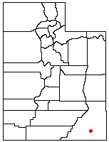
Location of Cedar Mesa in Utah

Cedar Mesa is a plateau in San Juan County in the southeastern portion of the U.S. state of Utah. It extends from Elk Ridge in the north, Comb Wash to the east, the gorge of the San Juan River to the south, and Grand Gulch to the west, an area of over 400 square miles (1,000 km2). The center of the mesa is located at approximately 37°26'N and 109°55'W, at an elevation of 6,500 feet (2,000 m). The surrounding terrain has a typical elevation of just 4,200 feet (1,300 m) Most of Cedar Mesa is included in the newly declared (2016) Bears Ears National Monument.

Arch Canyon, Utah

This large difference in elevation has led to the formation of numerous canyons, cliffs, and other erosional features on the edges of the mesa. To the east are several canyons draining into Comb Wash, including Arch, Texas, Mule, Owl, Fish, McCloyd, and Road Canyons. Scattered throughout these canyons are cliff dwellings of the Ancient Puebloans.

To the southeast is an eroded area called the Valley of the Gods, and to the southwest is a deep gorge of the San Juan River, called the Goosenecks. High above, on the southern edge of Cedar Mesa, are Muley and Cedar Points.

Slickhorn Canyon, Utah
Moon House ruin, Cedar Mesa

The west side of Cedar Mesa also includes large canyons, including John's and Slickhorn Canyons, and the combination of Grand Gulch and Bullet Canyon known as the Grand Gulch Primitive Area. To the northwest is the Natural Bridges National Monument and Stimper Arch.

State Route 95 crosses the northern part of Cedar Mesa, while U.S. Route 163 passes to the south. Running up the center of the mesa is State Route 261. Gravel and dirt roads provide access in dry weather to the individual canyons, through the Valley of the Gods, and to Comb Wash.

and 23 Related for: Cedar Mesa information

Request time (Page generated in 0.8136 seconds.)

Cedar Mesa

Last Update:

37°25′59″N 109°55′01″W / 37.433°N 109.917°W / 37.433; -109.917 Cedar Mesa is a plateau in San Juan County in the southeastern portion of the U.S. state...

Word Count : 491

Cedar Mesa Sandstone

Last Update:

Cedar Mesa Sandstone (also known as the Cedar Mesa Formation) is a sandstone member of the Cutler Formation, found in southeast Utah, southwest Colorado...

Word Count : 946

Druid Arch

Last Update:

Druid Arch is an iconic 150-foot tall Cedar Mesa Sandstone arch located within the Needles District of Canyonlands National Park, in San Juan County, Utah...

Word Count : 362

Moon House

Last Update:

is a Pueblo III-period cliff dwelling located in southeastern Utah on Cedar Mesa in Bears Ears National Monument. It was created by the Ancestral Puebloan...

Word Count : 625

Bears Ears

Last Update:

Creek and Canyonlands National Park. Rising 2,000 feet (610 m) above Cedar Mesa to the south, the Bears Ears reach 8,700 feet (2,700 m) in elevation and...

Word Count : 174

Valley of the Gods

Last Update:

Utah State Route 261 shortly before its 1,200-foot (370 m) ascent up Cedar Mesa at Moki Dugway, while the eastern end starts nine miles (14 km) from the...

Word Count : 383

Utah State Route 95

Last Update:

Utah. The highway is an access road for tourism in the Lake Powell and Cedar Mesa areas, notably bisecting Bears Ears National Monument and providing the...

Word Count : 617

Bears Ears National Monument

Last Update:

ancestors of most of the indigenous cultures of the Americas,: 228  hunted in Cedar Mesa, most of which is now included in the Bears Ears National Monument. Their...

Word Count : 9195

Natural Bridges National Monument

Last Update:

natural bridge in the world, carved from the white Permian sandstone of the Cedar Mesa Formation that gives White Canyon its name. The three bridges in the park...

Word Count : 1415

Angel Arch

Last Update:

and Kevin Chase. This geological formation is an eroded fin composed of Cedar Mesa Sandstone, which is the remains of coastal sand dunes deposited about...

Word Count : 443

Cutler Formation

Last Update:

Sandstone (Utah) Organ Rock Shale (Arizona, Colorado, New Mexico, Utah) Cedar Mesa Sandstone (Arizona, Utah) lower Cutler beds (Arizona, Colorado, New Mexico...

Word Count : 1631

Quail rock art panel

Last Update:

American rock art located at the intersect of Grand Gulch and Step Canyon in Cedar Mesa, San Juan County, Utah. Grand Gulch contains a large number of relatively...

Word Count : 762

Geology of the Capitol Reef area

Last Update:

missing), Cedar Mesa Sandstone, and the Elephant Canyon (locally buried). Only the two sandstone members of the Cutler Formation, the Cedar Mesa and White...

Word Count : 5471

Organ Rock Formation

Last Update:

supercontinent Pangea. The Organ Rock Formation is conformably underlain by the Cedar Mesa Sandstone. It is conformably overlain by the De Chelly Sandstone around...

Word Count : 1810

White Rim Sandstone

Last Update:

Permian Cutler Group, and overlies the major Organ Rock Formation and Cedar Mesa Sandstone; and again overlies thinner units of the Elephant Canyon and...

Word Count : 514

Mississippian culture

Last Update:

2020-06-14. Retrieved 2010-02-04. "The Plaquemine Culture, A.D 1000". Cedar Mesa Project. Retrieved 2013-10-02. Ethridge, Robbie Franklyn (2010). From...

Word Count : 3263

Cedar City Regional Airport

Last Update:

Cedar City. Late in 2007, Mesa filed to discontinue service to Cedar City, and a new contract was awarded to SkyWest. Western Airlines flew to Cedar City...

Word Count : 1128

Esplanade Sandstone

Last Update:

Sandstone. The coeval sandstone geologic unit from eastern Utah is the Cedar Mesa Sandstone. In Grand Canyon, Isis Temple landform, north of Grand Canyon...

Word Count : 737

Geology of the Canyonlands area

Last Update:

inter-fingered with the red beds and later became the white-colored cliff-forming Cedar Mesa Sandstone. Today these two competing rock units are exposed in a 4 to...

Word Count : 1502

Halgaito Formation

Last Update:

Elephant Canyon may grade into the Halgaito and grades northward into the Cedar Mesa Formation. There is no designated type locality for the Halgaito. The...

Word Count : 296

Comb Wash

Last Update:

Arizona.) On the western edge of Comb Wash is a series of canyons draining Cedar Mesa. To the north is Arch Canyon, which has Texas Canyon as an upper tributary...

Word Count : 305

Stimper Arch

Last Update:

Arch is a well-known rock formation in the wall of Kane Gulch on the Cedar Mesa plateau in southeast Utah, in the United States. The arch has a span of...

Word Count : 91

Aeolian processes

Last Update:

finally drowned the erg and deposited the beds of the Weissliegend. The Cedar Mesa Sandstone in Utah was contemporary with the Rogliegend. This formation...

Word Count : 6008

PDF Search Engine © AllGlobal.net