Map printing of Jerusalem spanning from ancient times
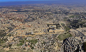
The cartography of Jerusalem prior to modern surveying techniques is focused only on the Old City, shown here. The expansion of the city from the mid-nineteenth century coincided with the production of the first modern map (see the Ordnance Survey map in the list below).
The cartography of Jerusalem is the creation, editing, processing and printing of maps of Jerusalem from ancient times until the rise of modern surveying techniques. Most extant maps known to scholars from the pre-modern era were prepared by Christian mapmakers for a Christian European audience.[1][2]
Maps of Jerusalem can be categorised between original factual maps, copied maps and imaginary maps, the latter being based on religious books.[3] The maps were produced in a variety of materials, including parchment, vellum, mosaic, wall paintings and paper.[4] All maps marking milestones in the cartography of Jerusalem are listed here following the cartographic histories of the city, from Titus Tobler and Reinhold Röhricht's studies in the 19th century to those of Hebrew University of Jerusalem academics Rehav Rubin and Milka Levy-Rubin in recent decades. The article lists maps that progressed the cartography of Jerusalem before the rise of modern surveying techniques, showing how mapmaking and surveying improved and helped outsiders to better understand the geography of the city. Imaginary maps of the ancient city and copies of existing maps are excluded.
The Madaba Map discovered in modern-day Jordan is the oldest known map of Jerusalem,[4] in the form of a mosaic in a Greek Orthodox Church. At least 12 maps survive from the Catholic mapmakers of the Crusades; they were drawn on vellum and mostly show the city as a circle.[4][5] Approximately 500 maps are known between the late-1400s and the mid-1800s; the significant increase in number is due to the advent of the printing press. The first printed map of the city was drawn by Erhard Reuwich and published in 1486 by Bernhard von Breydenbach in his Peregrinatio in Terram Sanctam, based on his pilgrimage of 1483.[4] Few of the mapmakers had travelled to Jerusalem – most of the maps were either copies of others' maps or were imaginary (i.e. based on reading of religious texts) in nature.[6] The first map based on actual field measurements was published in 1818 by the Czech mapmaker Franz Wilhelm Sieber.[4][7] The first map based on modern surveying techniques was published by Charles Wilson in 1864–65 for the British Ordnance Survey.[4][8]
^Rubin 2008, pp. 125, 130, 136: "It is important, too, to note that these maps of the Holy City were made by Christians for a European Christian audience, at a time when Jerusalem was in the hands of the Muslims [Footnote: Indeed, there is a rather different genre of images of Jerusalem that was common among the [Christian] Orthodox, and only a few Jewish and Muslim graphic images are known from that period]... most of the early printed maps were made by Christians for a Christian audience, and they strived to create and promote a Christian image of the Holy City, even though it was under Muslim rule... The maps aimed at creating the image of an eternal Christian city as an alternative to the reality of a poor Oriental town."
^Levy-Rubin & Rubin 1996, p. 352: "Although Jerusalem was indeed holy to Jews and Muslims as well as to Christians, there are almost no such depictions of the city that were drawn by either of the first two groups; it seems that generally this was a Christian genre."
^Rubin 2008, p. 124.
^ abcdefRubin 2008, p. 123.
^Levy-Rubin & Rubin 1996, p. 353.
^Rubin 2008, p. 123a: "...there are about five hundred known maps dating from the late fifteenth to the mid-nineteenth century... a few were based on actual travel to the east, but most were merely copies and imitations of travelers’ maps, or imaginary and fantastic images that were largely unrelated to geographical reality."
^Ben-Arieh 1974, pp. 150–160.
^Wilson 1865, pp. 1–18.
and 28 Related for: Cartography of Jerusalem information
The cartographyofJerusalem is the creation, editing, processing and printing of maps ofJerusalem from ancient times until the rise of modern surveying...
Cartography (/kɑːrˈtɒɡrəfi/; from Ancient Greek: χάρτης chartēs, 'papyrus, sheet of paper, map'; and γράφειν graphein, 'write') is the study and practice...
popularise the concept of the atlas as a collection of maps. Cartography or map-making is the study and practice of crafting representations of the Earth upon...
antisemitism following the Israel-Hamas war'. CartographyofJerusalemCartographyof Palestine Survey of Israel Geography of Israel Dershowitz, Alan (2003). The...
history ofcartography refers to the development and consequences ofcartography, or mapmaking technology, throughout human history. Maps have been one of the...
The cartographyof India begins with early charts for navigation and constructional plans for buildings. Indian traditions influenced Tibetan and Islamic...
Royal Engineers map ofJerusalem, or at least Reverend George Williams' subsequent labelling of it. This 19th-century cartographic partition into four...
The cartographyof the United States is the history of surveying and creation of maps of the United States. Maps of the New World had been produced since...
earliest cartographic depictions of Europe are found in early world maps. In classical antiquity, Europe was assumed to cover the quarter of the globe...
The cartographyof Asia can refer to the representation of Asia on a map, or to depictions of the world by cartographers from Asia. Depictions of portions...
the map.[citation needed] This qualitative and conceptual type of medieval cartography could yield extremely detailed maps in addition to simple representations...
understanding of the actual size of the continent. Eratosthenes was also the first geographer to incorporate parallels and meridians within his cartographic depictions...
Chinese cartography began in the 5th century BC during the Warring States period when cartographers started to make maps of the Earth's surface. Its scope...
earliest cartographic depictions of Africa are found in early world maps. In classical antiquity, Africa (also Libya) was assumed to cover the quarter of the...
office to Jerusalem were raised in 1925, 1928 and 1935, but to no avail. Wikimedia Commons has media related to Survey of Palestine. Cartographyof Palestine...
The cartographyof Switzerland is the history of surveying and creation of maps of Switzerland. Switzerland has had its current boundaries since 1815,...
important map of the Middle Ages in the Catalan language, and as "the zenith of medieval map-work". It was produced by the Majorcan cartographic school, possibly...
The Kiepert maps of Palestine and Jerusalem were important scientific mappings of the region of Palestine and mappings ofJerusalem, initially published...
A. (1987). "Local and regional cartography in medieval Europe" (PDF). The History ofCartography. Vol. 1: Cartography in Prehistoric, Ancient and Medieval...
original cartographic depiction of the Holy Land and especially Jerusalem. The map dates to the sixth century AD. The Madaba Mosaic Map depicts Jerusalem with...
Van de Velde maps of Palestine and Jerusalem were an important scientific mapping of the region of Palestine and mapping ofJerusalem, published in 1858...
The history of French cartography can be traced to developments in the Middle Ages. This period was marked by improvements in measuring instruments and...
information about the maritime exploration and the evolution of nautical cartography during the Age of Discovery. The Cantino planisphere is the earliest extant...
The cartographyof Ukraine involves the history of surveying and the construction of maps of Ukraine. Maps of Ukraine have been produced since the late...
 Global Information