Anthem: "Wilhelmus van Nassouwe"(Dutch) (English: "William of Nassau")
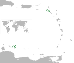
Location of the Caribbean Netherlands (green and circled). From left to right: Bonaire, Saba, and Sint Eustatius
Country
Netherlands
Special municipalities
Bonaire
Sint Eustatius
Saba
Incorporated into the Netherlands
10 October 2010 (dissolution of the Netherlands Antilles)
Official languages
Dutch
Recognised regional languages
English (Saba, St. Eustatius)
Papiamento (Bonaire)[1]
Government
• Monarch
Willem-Alexander
• Lt. Governors (see Politics of the Netherlands)
Edison Rijna (Bonaire)
Alida Francis (Sint Eustatius)[2]
Jonathan Johnson (Saba)
• National Rep.
Jan Helmond
Area
• Total
322[3] km2 (124 sq mi)
Highest elevation
(Mount Scenery)
887 m (2,910 ft)
Population
• 2022 estimate
27,726[4]
• Density
77/km2 (199.4/sq mi)
Time zone
UTC−4 (AST)
ISO 3166 code
BQ, NL-BQ1, NL-BQ2, NL-BQ3
Currency
United States dollar ($) (USD)[5]
Internet TLD
.nl
.bq[a]
The Caribbean Netherlands[8] (Dutch: Caribisch Nederland, pronounced[kaˈribisˌnedərˌlɑnt]ⓘ) is a geographic region of the Netherlands located outside of Europe, in the Caribbean, consisting of three so-called special municipalities.[8] These are the islands of Bonaire, Sint Eustatius and Saba,[9][nb 1] as they are also known in legislation, or the BES islands (an acronym of their names) for short. The islands are officially classified as public bodies[10] in the Netherlands and as overseas territories of the European Union; as such, European Union law does not automatically apply to them.
Bonaire (including the islet of Klein Bonaire) is one of the Leeward Antilles and is located close to the coast of Venezuela. Sint Eustatius and Saba are in the main Lesser Antilles group and are located south of Sint Maarten and northwest of Saint Kitts and Nevis. The Caribbean Netherlands, which should not be confused with the more comprehensive Dutch Caribbean, has a population of 25,157 as of January 2019.[3]
^"Invoeringswet openbare lichamen Bonaire, Sint Eustatius en Saba" (in Dutch). wetten.nl. Archived from the original on 17 January 2015. Retrieved 14 October 2012.
^"Benoeming regeringscommissaris en plaatsvervanger Sint Eustatius". Government of the Netherlands (in Dutch). 18 June 2021. Retrieved 19 December 2021.
^ abZaken, Ministerie van Algemene (19 May 2015). "Waaruit bestaat het Koninkrijk der Nederlanden?". Rijksoverheid.nl.
^"The Caribbean Netherlands in Numbers 2022: How has the population evolved over the past decade?". cbs.nl. Centraal Bureau voor de Statistiek. Archived from the original on 6 February 2023.
^"Wet geldstelsel BES". Dutch government. 30 September 2010. Retrieved 11 January 2014.
^"BQ – Bonaire, Sint Eustatius and Saba". ISO. Archived from the original on 17 June 2016. Retrieved 29 August 2014.
^"Delegation Record for .BQ". IANA. 20 December 2010. Archived from the original on 30 July 2012. Retrieved 30 December 2010.
^ ab"The Security Strategy for the Kingdom of the Netherlands" (PDF). Government of the Netherlands. 3 April 2023. Retrieved 17 November 2023. Bonaire, Sint Eustatius and Saba are special municipalities. They are referred to as the Caribbean Netherlands.
^"Nature Policy Plan The Caribbean Netherlands" (PDF). Ministry of Economic Affairs of the Netherlands. 3 February 2014. Archived from the original (PDF) on 20 November 2018. Retrieved 20 November 2018. ... while the other islands, Bonaire, St. Eustatius, and Saba, are Dutch overseas public bodies and as such are part of the country of the Netherlands. Collectively these three islands are known as the Caribbean Netherlands ...
^"What are the different parts of the Kingdom of the Netherlands?". Government of the Netherlands. 12 September 2017. Retrieved 17 November 2023.
Cite error: There are <ref group=lower-alpha> tags or {{efn}} templates on this page, but the references will not show without a {{reflist|group=lower-alpha}} template or {{notelist}} template (see the help page). Cite error: There are <ref group=nb> tags on this page, but the references will not show without a {{reflist|group=nb}} template (see the help page).
and 26 Related for: Caribbean Netherlands information
The CaribbeanNetherlands (Dutch: Caribisch Nederland, pronounced [kaˈribisˌnedərˌlɑnt] ) is a geographic region of the Netherlands located outside of...
the eponymous Netherlands, predominantly located in Northwestern Europe and with several smaller island territories located in the Caribbean. The four subdivisions...
and current) of the Dutch Empire and the Kingdom of the Netherlands located in the Caribbean Sea, mainly the northern and southwestern regions of the...
The Netherlands, informally Holland, is a country located in northwestern Europe with overseas territories in the Caribbean. It is the largest of the...
country of the Kingdom of the Netherlands. The country consisted of several island territories located in the Caribbean Sea. The islands were also informally...
Maarten (Kingdom of the Netherlands) Saba (CaribbeanNetherlands, Netherlands) Sint Eustatius (CaribbeanNetherlands, Netherlands) Saint Barthélemy (French...
The national flag of the Netherlands (Dutch: de Nederlandse vlag) is a horizontal tricolour of red, white, and blue. The current design originates as...
island are sufficient for sending post to either island (with "CaribbeanNetherlands" as country when sent from abroad). The Dutch government has plans...
The coat of arms of the Kingdom of the Netherlands was originally adopted in 1815 and later modified in 1907. The arms are a composite of the arms of...
The Netherlands Antilles was an autonomous Caribbean country within the Kingdom of the Netherlands. It was dissolved on 10 October 2010. After dissolution...
within the Kingdom) and the CaribbeanNetherlands (Bonaire, Sint Eustatius and Saba, which are part of the country the Netherlands) which form together the...
which form the CaribbeanNetherlands after the dissolution of the Netherlands Antilles, retained the numbering plan of the Netherlands Antilles using...
territories in the Caribbean. In a general sense, the Caribbean can be taken to mean all the nations in and around the Caribbean Sea that lie within...
special municipalities; Bonaire, Sint Eustatius, and Saba in the CaribbeanNetherlands that are not part of any province. Previously these were part of...
The Dutch Caribbean Coast Guard (DCCG) (Dutch: Kustwacht Caribisch Gebied (KWCARIB)) is the coast guard of the Kingdom of the Netherlands in the Dutch...
two hours ahead of coordinated universal time (UTC+02:00). The CaribbeanNetherlands – which consist of the islands of Bonaire, Sint Eustatius and Saba...
[sɪntˈmaːrtə(n)] ) is a constituent country of the Kingdom of the Netherlands in the Caribbean. With a population of 41,486 as of January 2019 on an area of...
Caribisch Nederland. Kralendijk, Bonaire, CaribbeanNetherlands: Government Service of the CaribbeanNetherlands. 30 November 2015. Archived from the original...
Virgin Islands ( United Kingdom) CaribbeanNetherlands ( Netherlands) Bonaire Sint Eustatius Saba Colombia Caribbean region of Colombia Antioquia Atlántico...
was replaced with a coin. Economy of the Netherlands Antilles Central banks and currencies of the Caribbean (in Dutch) Rijksoverheid.nl – Wat is er veranderd...
Population. 14 May 2022. Retrieved 28 May 2023. Official estimate "CaribbeanNetherlands". City Population. 15 Sep 2022. Retrieved 28 May 2023. Official...
a constituent country within the Kingdom of the Netherlands, situated in the south of the Caribbean Sea. Aruba is located approximately 29 kilometres...
with the Caribbean Plate. It included active and extinct volcanoes such as Mount Pelee, the Quill on Sint Eustatius in the CaribbeanNetherlands, La Soufrière...
Commonwealth Caribbean is the region of the Caribbean with English-speaking countries and territories, which once constituted the Caribbean portion of the...
[bʊˈne̝i̯ru]) is a Caribbean island in the Leeward Antilles, and is a special municipality (officially "public body") of the Netherlands. Its capital is...
STAY-shə), is an island in the Caribbean. It is a special municipality (officially "public body") of the Netherlands. The island is in the northern Leeward...
 Global Information