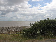
Bridgwater Bay is on the Bristol Channel, 5 kilometres (3.1 mi) north of Bridgwater in Somerset, England at the mouth of the River Parrett and the end of the River Parrett Trail. It stretches from Minehead at the southwestern end of the bay to Brean Down in the north. The area consists of large areas of mudflats, saltmarsh, sandflats and shingle ridges, some of which are vegetated. It has been designated as a Site of Special Scientific Interest (SSSI) covering an area of 3,574.1 hectares (35.741 km2; 13.800 sq mi)[1] since 1989,[2] and is designated as a wetland of international importance under the Ramsar Convention.[3] The risks to wildlife are highlighted in the local Oil Spill Contingency Plan.[4]
Several rivers, including the Parrett, Brue and Washford, drain into the bay. Man-made drainage ditches from the Somerset Levels, including the River Huntspill, also run into the bay. The mud flats provide a habitat for a wide range of flora and fauna. These include some nationally rare plants, beetles and snails. It is particularly important for overwintering waders and wildfowl, with approximately 190 species recorded including Eurasian whimbrel (Numenius phaeopus), black-tailed godwit (Limosa limosa), dunlin (Calidris alpina) and wigeon (Anas penelope). Fishing has taken place using shallow boats, known as flatners, and fixed wooden structures for hundreds of years. It was also the last site in England used for 'mudhorse fishing'. There are several small harbours along the coast.
The low-lying areas of the bay have been subject to flooding, including the Bristol Channel floods of 1607 and many times since particularly around the Steart Peninsula. In response to this threat sea walls have been built at several points including at Burnham-on-Sea, Berrow and Blue Anchor to Lilstock Coast. The extensive mud flats and high tidal range have been the cause of several drownings and rescue services are now provided by the Burnham Area Rescue Boat.
^"Bridgwater Bay SSSI". Natural England. Retrieved 7 January 2017.
^"SSSI citation sheet" (PDF). Sites of Special Scientific Interest. English Nature. Archived from the original (PDF) on 10 September 2008. Retrieved 12 November 2008.
^"Bridgwater Bay NNR". National Nature Reserves. Natural England. Retrieved 27 January 2017.
^"Oil spill contingency plan". Sedgemoor Council. Archived from the original on 3 June 2011. Retrieved 13 November 2008.
BridgwaterBay is on the Bristol Channel, 5 kilometres (3.1 mi) north of Bridgwater in Somerset, England at the mouth of the River Parrett and the end...
Bridgwater is a historic market town and civil parish in Somerset, England. The town had a population of 41,276 at the 2021 census. Bridgwater is at the...
Somerset and the Somerset Levels to its mouth at Burnham-on-Sea, into the BridgwaterBay nature reserve on the Bristol Channel, the Parrett and its tributaries...
is being developed by the Royal Society for the Protection of Birds. BridgwaterBay, a national nature reserve, lies on the northern side of the peninsula...
The Bridgwater and Taunton Canal is a canal in the south-west of England between Bridgwater and Taunton, opened in 1827 and linking the River Tone to...
Somerset, England. It was built in 1940 to supply process water to ROF Bridgwater, and has resulted in reduced flooding of the lower Brue Valley. Huntspill...
intact juvenile plesiosaur was discovered, by a local fisherman, at BridgwaterBay National Nature Reserve in Somerset, UK. The fossil, dating from 180 million...
the Iron Age and then a post Roman cemetery. Hinkley Point adjoins BridgwaterBay, a Site of Special Scientific Interest and nature reserve, and is a...
Brean Down is known as BridgwaterBay, and is a National Nature Reserve. North of that, the coast forms Weston Bay and Sand Bay whose northern tip, Sand...
(population 18,401) is at the mouth of the River Parrett where it enters BridgwaterBay. The position of the town on the edge of the Somerset Levels has resulted...
parish extends to the coast of BridgwaterBay between Blue Anchor and Watchet, in an area previously known as Cleeve Bay, on the Blue Anchor to Lilstock...
extends from Brean Down to Hinkley Point in BridgwaterBay, and parts of the rivers Parrett (to Bridgwater), River Brue and River Axe. Although no ships...
east of Minehead. The town lies at the mouth of the Washford River on BridgwaterBay, part of the Bristol Channel, and on the edge of Exmoor National Park...
operates between Sand Bay and Weston-Super-Mare town centre, using open-top buses weather permitting, all year round. "BridgwaterBay" (PDF). SSSI citation...
Area Rescue Boat (BARB) are used to rescue people from thick mud in BridgwaterBay. Avon Fire and Rescue Service became the first Local Authority fire...
Somerset, England. It lies opposite Burnham-on-Sea, and is part of the BridgwaterBay Nature Reserve. Stert Island was formed in about 1798, when it broke...
miles (2.5 kilometres) into the Bristol Channel at the eastern end of BridgwaterBay between Weston-super-Mare and Burnham-on-Sea. Made of Carboniferous...
Arcachon Bay, France Banc d'Arguin, Mauritania Chamiza Wetland, Chile Great Rann of Kutch, India Belhaven, East Lothian Scotland, United Kingdom Bridgwater Bay...
and has protected areas, including national nature reserves such as BridgwaterBay at the mouth of the River Parrett. At low tide large parts of the channel...
burial 932 to 966 fishing at BridgwaterBay, Bristol Channel, England; 'mudhorse fishing', with structures built in the bay at Stert Flats 963 (from ~800...
estuary are also important feeding grounds for waders, notably at the BridgwaterBay National Nature Reserve and the Slimbridge Wildfowl Trust. River shingle...
major part of a larger area which includes the Taff/Ely Estuary and BridgwaterBay (as well as the Upper Severn Estuary) The Upper Severn Estuary SSSI...
Alaska. In the United Kingdom large bay mud occurrences are found at Morecambe Bay, BridgwaterBay and Bristol Bay. Straddling Denmark, the Netherlands...
Estuary Beaulieu River Blackwater Estuary Blue Anchor Bay Blyth Estuary Breydon Water BridgwaterBay Camel Estuary Carrick Roads Chichester Harbour Christchurch...
operates two rescue hovercraft and two inshore rescue boats in the BridgwaterBay area. It is a registered charity. It operates BBV hovercraft and small...
(80 km) long, runs from Chedington in Dorset to the mouth of the river in BridgwaterBay where it joins the West Somerset Coast Path. It passes many landmarks...
Hinkley Point B nuclear power station was a nuclear power station near Bridgwater, Somerset, on the Bristol Channel coast of south west England. It was...
 Global Information