Coastal plain and wetland area of Somerset, England
Designations
Ramsar Wetland
Official name
Somerset Levels and Moors
Designated
26 June 1997
Reference no.
914[1]
The Somerset Levels, seen from Glastonbury TorMap showing the Somerset Levels and the surrounding area. The major hill ranges and rivers are shown. Height (m)
0–20
20–40
40–60
60–80
80–100
100–120
120–140
140–160
160–180
180–200
200–230
230–260
260–300
300–384
Source: Ordnance Survey OpenData
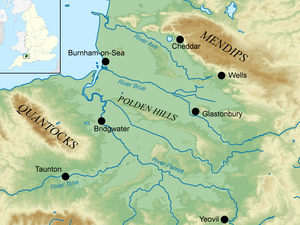
The Somerset Levels are a coastal plain and wetland area of Somerset, England, running south from the Mendips to the Blackdown Hills.
The Somerset Levels have an area of about 160,000 acres (650 km2) and are bisected by the Polden Hills; the areas to the south are drained by the River Parrett, and the areas to the north by the rivers Axe and Brue. The Mendip Hills separate the Somerset Levels from the North Somerset Levels. The Somerset Levels consist of marine clay "levels" along the coast and inland peat-based "moors"; agriculturally, about 70 per cent is used as grassland and the rest is arable. Willow and teazel are grown commercially and peat is extracted.
A Palaeolithic flint tool found in West Sedgemoor is the earliest indication of human presence in the area. The Neolithic people exploited the reed swamps for their natural resources and started to construct wooden trackways, including the world's oldest known timber trackway, the Post Track, dating from about 3800 BC. The Levels were the location of the Glastonbury Lake Village as well as two Lake villages at Meare Lake. Several settlements and hill forts were built on the natural "islands" of slightly raised land, including Brent Knoll and Glastonbury. In the Roman period sea salt was extracted and a string of settlements were set up along the Polden Hills. The discovery at Shapwick of 9,238 silver Roman coins, known as the Shapwick Hoard, was the second-largest ever found from the time of the Roman Empire. A number of Saxon charters document the incorporation of areas of moor in estates. In 1685, the Battle of Sedgemoor was fought in the Bussex area of Westonzoyland at the conclusion of the Monmouth Rebellion.
As a result of the wetland nature of the Levels, the area contains a rich biodiversity of national and international importance. It supports a vast variety of plant and bird species and is an important feeding ground for birds and includes 32 Sites of Special Scientific Interest, of which 12 are also Special Protection Areas. The area has been extensively studied for its biodiversity and heritage, and has a growing tourism industry.
People have been draining the area since before Domesday Book. In the Middle Ages, the monasteries of Glastonbury, Athelney and Muchelney were responsible for much of the drainage. The artificial Huntspill River was constructed during the Second World War as a reservoir, although it also serves as a drainage channel. The Sowy River between the River Parrett and King's Sedgemoor Drain was completed in 1972; water levels are managed by the Levels internal drainage boards. During 2009 and 2010 proposals to build a series of electricity pylons by one of two routes between Hinkley Point and Avonmouth, to transmit electricity from the proposed Hinkley Point C nuclear power station, attracted local opposition. Discussions have taken place concerning the possibility of obtaining World Heritage Site status for the Somerset Levels as a "cultural landscape".[2] It was suggested that if this bid were successful it could improve flood control, but only if wetland fens were created again; the plans were abandoned in 2010.[3]
^"Somerset Levels and Moors". Ramsar Sites Information Service. Retrieved 25 April 2018.
^Norman, Kirsty (December 2009). "World Heritage for the Nation: Analysis of responses" (PDF). UK Overseas Territories Conservation Forum. Archived from the original (PDF) on 19 July 2011. Retrieved 17 June 2010.
^"Cabinet member decision record" (PDF). Somerset County Council. Archived (PDF) from the original on 14 October 2011. Retrieved 5 September 2010.
of the West of England Combined Authority. The centre of Somerset is dominated by the Levels, a coastal plain and wetland. The north-east contains part...
The North SomersetLevels is a coastal plain, an expanse of low-lying flat ground, which occupies an area between Weston-super-Mare and Bristol in North...
The following is a list of locations in the SomersetLevels, England. Aller, Somerset Alhampton Andersea Athelney Baltonsborough Banwell Barrow (North/South)...
GLAHST-) is a town and civil parish in Somerset, England, situated at a dry point on the low-lying SomersetLevels, 23 miles (37 km) south of Bristol. The...
Quantocks is the large area of flat, low-lying ground known as the SomersetLevels. The county's main rivers are the River Axe in the northeast, and the...
Peat has been extracted from the SomersetLevels in South West England since the area was first drained by the Romans, and continues in the 21st century...
One of the earliest known wooden causeways is the Sweet Track in the SomersetLevels, England, which dates from the Neolithic age. Timber causeways may...
The Sweet Track is an ancient trackway, or causeway, in the SomersetLevels, England, named after its finder, Ray Sweet. It was built in 3807 BC (determined...
Vale was Thomas Hardy's "Vale of the Little Dairies"; another, the SomersetLevels was created by reclaiming wetlands. The Southern England Chalk Formation...
"a slap on the wrist" for ministers. From December 2013 onwards the SomersetLevels suffered severe flooding as part of the wider 2013-2014 Atlantic winter...
year 3900 BC to 3801 BC. The Post Track, an ancient causeway in the SomersetLevels, England, is built, c. 3838 BC. It is one of the oldest engineered...
village and civil parish in the county of Somerset, England. It is situated on raised ground, in the SomersetLevels between the River Axe and River Brue,...
hills around Chedington in Dorset. Flowing northwest through Somerset and the SomersetLevels to its mouth at Burnham-on-Sea, into the Bridgwater Bay nature...
'very great swampy and impassable marshes' of the SomersetLevels. Much of the Levels are below the level of high tide. They are now drained for agricultural...
road work in Great Britain is the Sweet Track, constructed across the SomersetLevels with wooden planks in the 39th century BCE. Following the Roman Empire's...
of Somerset plays covering the four seasons[needs update] the first being the award winning Comfort Me with Apples. The play is set on the Somerset Levels...
early example is the Sweet Track that Neolithic people built in the Somersetlevels, England, around 6000 years ago. This track consisted mainly of planks...
water-related features. The low-lying areas of the North SomersetLevels and SomersetLevels have been subject to thousands of years of flooding and man's...
situated on a low hill in the marshy, and once frequently flooded, SomersetLevels, and Wareham in Dorset surrounded by flood plains to the west and Poole...
 Global Information