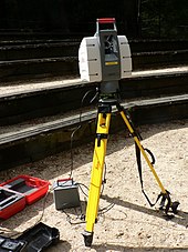
Lidar-derived image of Marching Bears Mound Group, Effigy Mounds National MonumentA frequency addition source of optical radiation (FASOR) used at the Starfire Optical Range for lidar and laser guide star experiments is tuned to the sodium D2a line and used to excite sodium atoms in the upper atmosphere.This lidar may be used to scan buildings, rock formations, et cetera, to produce a 3D model. The lidar can aim its laser beam in a wide range: its head rotates horizontally; a mirror tilts vertically. The laser beam is used to measure the distance to the first object on its path.
An airplane collecting treetop data over a Brazilian rainforest
In this view, the viewer flies down to the rainforest canopy and flies through the virtual leaves.
This visualisation shows an airplane collecting a 50 km swathe of lidar data over the Brazilian rainforest. For ground-level features, colours range from deep brown to tan. Vegetation heights are depicted in shades of green, where dark greens are closest to the ground and light greens are the highest.
Lidar (/ˈlaɪdɑːr/, also LIDAR, LiDAR or LADAR, an acronym of "light detection and ranging"[1] or "laser imaging, detection, and ranging"[2]) is a method for determining ranges by targeting an object or a surface with a laser and measuring the time for the reflected light to return to the receiver. Lidar may operate in a fixed direction (e.g., vertical) or it may scan multiple directions, in which case it is known as lidar scanning or 3D laser scanning, a special combination of 3-D scanning and laser scanning.[3] Lidar has terrestrial, airborne, and mobile applications.[4][5]
Lidar is commonly used to make high-resolution maps, with applications in surveying, geodesy, geomatics, archaeology, geography, geology, geomorphology, seismology, forestry, atmospheric physics,[6] laser guidance, airborne laser swathe mapping (ALSM), and laser altimetry. It is used to make digital 3-D representations of areas on the Earth's surface and ocean bottom of the intertidal and near coastal zone by varying the wavelength of light. It has also been increasingly used in control and navigation for autonomous cars[7] and for the helicopter Ingenuity on its record-setting flights over the terrain of Mars.[8]
The evolution of quantum technology has given rise to the emergence of Quantum LiDAR, demonstrating higher efficiency and sensitivity when compared to conventional LiDAR systems.[9]
^National Oceanic and Atmospheric Administration (26 February 2021). "What is LIDAR". oceanservice.noaa.gov. US Department of Commerce. Retrieved 15 March 2021.
^Travis S. Taylor (2019). Introduction to Laser Science and Engineering. CRC Press.
^Jie Shan and Charles K. Toth (2018). Topographic Laser Ranging and Scanning: Principles and Processing (2nd ed.). CRC Press.
^"Ecologists compare accuracy of Lidar technologies for monitoring forest vegetation: Findings suggest mobile platforms have great potential for monitoring a variety of forest attributes". ScienceDaily. Retrieved 2021-07-14.
^Cracknell, Arthur P.; Hayes, Ladson (2007) [1991]. Introduction to Remote Sensing (2 ed.). London: Taylor and Francis. ISBN 978-0-8493-9255-9. OCLC 70765252.
^Lim, Hazel Si Min; Taeihagh, Araz (2019). "Algorithmic Decision-Making in AVs: Understanding Ethical and Technical Concerns for Smart Cities". Sustainability. 11 (20): 5791. arXiv:1910.13122. doi:10.3390/su11205791.
^"How NASA Designed a Helicopter That Could Fly Autonomously on Mars". IEEE Spectrum. 17 February 2021. Archived from the original on 19 February 2021. Retrieved 19 February 2021.
^Gallego Torromé, Ricardo; Barzanjeh, Shabir (2023). "Advances in quantum radar and quantum LiDAR". Progress in Quantum Electronics: 100497. arXiv:2310.07198. doi:10.1016/j.pquantelec.2023.100497.
Lidar (/ˈlaɪdɑːr/, also LIDAR, LiDAR or LADAR, an acronym of "light detection and ranging" or "laser imaging, detection, and ranging") is a method for...
Lidar has a wide range of applications; one use is in traffic enforcement and in particular speed limit enforcement, has been gradually replacing radar...
Atmospheric lidar is a class of instruments that uses laser light to study atmospheric properties from the ground up to the top of the atmosphere. Such...
Velodyne Lidar is a Silicon Valley-based lidar technology company, headquartered in San Jose, California. It was spun off from Velodyne Acoustics in 2016...
piezo sensors can be detected. LIDAR devices require an optical-band sensor, although many modern detectors include LIDAR sensors. Most of today's radar...
Lidar Church (Norwegian: Lidar kyrkje) is a parish church of the Church of Norway in Øystre Slidre Municipality in Innlandet county, Norway. It is located...
measurements are conducted with various methods, from depth sounding, sonar and Lidar techniques, to buoys and satellite altimetry. Various methods have advantages...
(LASer) format is a file format designed for the interchange and archiving of lidar point cloud data. It is an open, binary format specified by the American...
Technologies Inc. is an American technology company that develops vision-based lidar and machine perception technologies, primarily for self-driving cars. The...
A national lidar dataset refers to a high-resolution lidar dataset comprising most—and ideally all—of a nation's terrain. Datasets of this type typically...
deforestation has contributed to atmospheric CO2 concentrations. A full-waveform LIDAR was attached to the International Space Station to provide the first global...
website. LiDAR, an acronym for Light Detection and Ranging, is an optical remote sensing technology that can measure distance to objects. LiDAR data is...
development of the Lidar for the remote sensing of the atmosphere. In 1962 at MIT, together with Louis Smullin, Fiocco developed the first Lidar system, aiming...
"Assessing Vulnerability Due to Sea-level Rise in Maui, Hawai'i Using LiDAR Remote Sensing and GIS". Climatic Change. 116 (3–4): 547–563. Bibcode:2013ClCh...
developing a line of lidar products, particularly including those using multi-beam spinning lidar scanners mounted on automobiles. The lidar product line was...
vehicle. The system's sensors use Aurora's FirstLight lidar, which was developed from Blackmore's FMCW lidar technology. The first vehicle to be outfitted with...
Daniel Amihud Lidar is the holder of the Viterbi Professorship of Engineering at the University of Southern California, where he is a professor of electrical...
The Purple Crow Lidar is a powerful lidar (laser radar) that emits pulses of intensely bright light. The bright light scatters off air molecules, and...
effect vehicles, as compared to laser, isotropic or ultrasonic altimeters. Lidar technology is used to help navigate the helicopter Ingenuity on its record-setting...
(collimation), a feature used in applications such as laser pointers and lidar (light detection and ranging). Lasers can also have high temporal coherence...
will begin in 2026. XPeng uses a combination of lidar, radar, and a camera for driver aid. The lidar system uses laser light to create a 3D space by measuring...
input from sensors (such as cameras, microphones, wireless signals, active lidar, sonar, radar, and tactile sensors) to deduce aspects of the world. Computer...
2000). "How Computer Mice Work". HowStuffWorks. Retrieved 9 October 2019. "LiDAR vs. 3D ToF Sensors — How Apple Is Making AR Better for Smartphones". Retrieved...
needed to calibrate the altimeter. Stereoscopy in aerial photography. Aerial lidar and satellite laser altimetry. Aerial or satellite radar altimetry. Accurate...
 Global Information