 Global Information
Arunachal Pradesh information
Arunachal Pradesh | |
|---|---|
State | |
     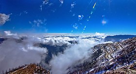 From top left to right: Golden Pagoda, Namsai, Tawang Monastery, Tutsa Naga Dancers, Ziro valley, Pakke Tiger Reserve, Sela Pass | |
 Emblem of Arunachal Pradesh | |
| Etymology: Arunachal ('dawn-lit mountains') and Pradesh ('province or territory') | |
| Nickname: "Land of Rising Sun" | |
| Motto: Satyameva Jayate (Truth Alone Triumphs) | |
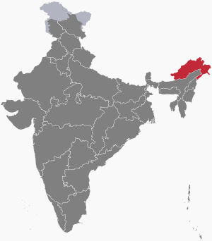 Location of Arunachal Pradesh in India | |
| Coordinates: 27°04′N 93°22′E / 27.06°N 93.37°E | |
| Country | |
| Region | Northeast India |
| Before was | North-East Frontier Agency |
| As union territory | 21 January 1972 |
| Formation | 20 February 1987[1] |
| Capital and largest city | Itanagar |
| Districts | 26 |
| Government [2][3][4] | |
| • Body | Government of Arunachal Pradesh |
| • Governor | Kaiwalya Trivikram Parnaik |
| • Chief minister | Pema Khandu (BJP) |
| State Legislature | Unicameral |
| • Assembly | Arunachal Pradesh Legislative Assembly (60 seats) |
| National Parliament | Parliament of India |
| • Rajya Sabha | 1 seat |
| • Lok Sabha | 2 seats |
| High Court | Gauhati High Court- Itanagar Bench |
| Area [5] | |
| • Total | 83,743 km2 (32,333 sq mi) |
| • Rank | 14th |
| Elevation [6] | 2,432 m (7,979 ft) |
| Highest elevation (Kangto) | 7,060 m (23,160 ft) |
| Lowest elevation | 44 m (144 ft) |
| Population (2011) | |
| • Total | |
| • Rank | 27th |
| • Density | 17/km2 (40/sq mi) |
| • Urban | 22.94% |
| • Rural | 77.06% |
| Demonym | Arunachalis |
| Language | |
| • Official | English[7][8][9] |
| • Official script | Latin script |
| GDP | |
| • Total (2023–24) | |
| • Rank | 31st |
| • Per capita | |
| Time zone | UTC+05:30 (IST) |
| ISO 3166 code | IN-AR |
| Vehicle registration | AR |
| HDI (2021) | |
| Literacy (2011) | |
| Sex ratio (2021) | 997♀/1,000 ♂[11] (5th) |
| Website | arunachalpradesh |
| Symbols of Arunachal Pradesh | |
Emblem of Arunachal Pradesh | |
| Foundation day | Arunachal Pradesh Day |
| Bird | Hornbill[12][13][14] |
| Fish | Golden Mahseerref [15] |
| Flower | Foxtail orchid[12][13][14] |
| Mammal | Mithun[12][13][14] |
| Tree | Hollong [16][17] |
| State highway mark | |
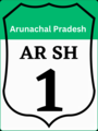 | |
| State highway of Arunachal Pradesh | |
| List of Indian state symbols | |
Arunachal Pradesh (/ɑːrəˌnɑːtʃəl prəˈdɛʃ/,[18] lit. 'Dawn-Lit Mountain Province')[19] is a state in northeast India. It was formed from the North-East Frontier Agency (NEFA) region, and India declared it as a state on 20 February 1987. Itanagar is its capital and largest town. It borders the Indian states of Assam and Nagaland to the south. It shares international borders with Bhutan in the west, Myanmar in the east, and a disputed 1,129 km border with China's Tibet Autonomous Region in the north at the McMahon Line.[20] Arunachal Pradesh is claimed by China as part of the Tibet Autonomous Region;[21] China occupied some regions of Arunachal Pradesh in 1962 but later withdrew its forces.[22][23]
As of the 2011 Census of India, Arunachal Pradesh has a population of 1,383,727 and an area of 83,743 square kilometres (32,333 sq mi). With only 17 inhabitants per square kilometre, it is the least densely populated state of India. It is an ethnically diverse state, with predominantly Monpa people in the west, Tani people in the centre, Mishmi and Tai people in the east, and Naga people in the southeast of the state. About 26 major tribes and 100 sub-tribes live in the state,[citation needed] including Nocte, Adi, Nyshi, Singpho, Galo, Tagin, Apatani. The Nyishi are the largest ethnic group in the region. The Mishmi tribe has three sub-tribes, namely Idu-Mishmi, Digaru-Mishmi and Miju-Mishmi.
- ^ Government Archived 7 October 2016 at the Wayback Machine
- ^ "Lt General Kaiwalya Trivikram Parnaik sworn - in as Arunachal Pradesh Governor". ThePrint. ANI. 16 February 2023. Archived from the original on 17 February 2023. Retrieved 17 February 2023.
- ^ "Pema Khandu sworn in as Chief Minister of Arunachal Pradesh". The Hindu. Archived from the original on 13 July 2019. Retrieved 6 August 2016.
- ^ "BJP forms govt in Arunachal Pradesh". The Hindu. Arunachal Pradesh. 31 December 2016. Archived from the original on 3 March 2018. Retrieved 31 December 2016.
- ^ "Arunachal Pradesh: Physiography, At a glance". gbpihedenvis.nic.in. Hosted by: G.B. Pant National Institute of Himalayan Environment and Sustainable Development. Sponsored by: Ministry of Environment, Forest & Climate Change, Govt of India. ENVIS Centre on Himalayan Ecology. Archived from the original on 24 June 2021. Retrieved 23 June 2021.
{{cite web}}: CS1 maint: others (link) - ^ "4 Reasons Why Arunachal Pradesh is a Natural Wonderland". Outlook India Traveller. 26 June 2018. Archived from the original on 24 June 2021. Retrieved 23 June 2021.
We may as well call Arunachal a flowery paradise. Arunachal is also called Orchid State of India
- ^ "Report of the Commissioner for linguistic minorities: 47th report (July 2008 to June 2010)" (PDF). Commissioner for Linguistic Minorities, Ministry of Minority Affairs, Government of India. pp. 122–126. Archived from the original (PDF) on 13 May 2012. Retrieved 16 February 2012.
- ^ "Ministry of Development of North Eastern Region, North East India". mdoner.gov.in. Archived from the original on 15 October 2023. Retrieved 22 February 2022.
- ^ "WORKING IN HINDI LANGUAGE" (PDF). rajbhasha.gov.in. Archived (PDF) from the original on 25 February 2023. Retrieved 22 February 2022.
- ^ "Subnational HDI". Archived from the original on 17 February 2022. Retrieved 31 January 2022.
- ^ "Sex ratio of State and Union Territories of India as per National Health survey (2019-2021)". Ministry of Health and Family Welfare, India. Archived from the original on 8 January 2023. Retrieved 29 January 2023.
- ^ a b c "Basic Statistical Figure of Arunachal Pradesh" (PDF). Archived from the original (PDF) on 2 February 2016. Retrieved 27 January 2016.
- ^ a b c "Symbols of Arunachal Pradesh". knowindia.gov.in. Archived from the original on 12 November 2013. Retrieved 15 October 2013.
- ^ a b c "Symbols of Arunachal Pradesh". Archived from the original on 11 March 2015. Retrieved 15 October 2013.
- ^ "State Fishes of India" (PDF). National Fisheries Development Board, Government of India. Archived (PDF) from the original on 10 October 2020. Retrieved 25 December 2020.
- ^ "State Trees and Flowers of India". flowersofindia.net. Archived from the original on 16 April 2016. Retrieved 27 January 2016.
- ^ "State Tree of Arunachal Pradesh" (PDF). Archived (PDF) from the original on 3 February 2016. Retrieved 27 January 2016.
- ^ "Arunachal Pradesh". Lexico UK English Dictionary. Oxford University Press. Archived from the original on 16 May 2021.
- ^ "'We Wake Up at 4 am': Arunachal Pradesh CM Pema Khandu Wants Separate Time Zone". Outlook. 12 June 2017. Archived from the original on 17 May 2018.
- ^ Choudhury, Ratnadip (23 September 2020). "Arunachal Residents Write To PM On Road Project, Quote National Security". NDTV.com. Archived from the original on 30 October 2020. Retrieved 27 January 2021.
- ^ Taylor Fravel, M. (14 September 2008). Strong Borders, Secure Nation. Princeton University Press. pp. 326–327. ISBN 978-0-691-13609-7. Archived from the original on 2 August 2023. Retrieved 2 August 2023.
The territorial dispute between China and India concerns three sectors. The eastern sector includes 90,000 square kilometers south of the McMahon Line and north of what China claims as Tibet's customary boundary, effectively the present-day Indian state of Arunachal Pradesh, previously known as the North Eastern Frontier Agency. India claims that the frontier here was delimited by the McMahon Line drawn at the 1913–14 Simla Conference. China does not recognize the McMahon Line itself or any of the documents from this conference, which it never ratified. In addition, as the line itself was drawn directly on a map, it lacks a precise delimitation. Historically, Tibet had administered the area around Tawang in the far western portion of this sector, where the sixth Dalai Lama was born, and claimed additional areas on the southern slope. After independence in 1947, India moved to assert its authority, slowly administering this region in the early 1950s and in some cases replacing local Tibetan officials.
- ^ Mayilvaganan, M.; Bej, Sourina; Khatoon, Nasima, eds. (2020). Tawang, Monpas and Tibetan Buddhism in Transition. Springer Nature. p. 22.
- ^ Guyot-Réchard, Bérénice, ed. (2016), "Open War: State-Making's Dress Rehearsal", Shadow States: India, China and the Himalayas, 1910–1962, Cambridge: Cambridge University Press, pp. 232–264, doi:10.1017/9781316796894.012, ISBN 978-1-107-17679-9, archived from the original on 14 June 2018, retrieved 12 June 2023