This article is about the North Eastern Region (NER) of India. For other uses, see Northeast (disambiguation).
Place in India
Northeast India
North Eastern Region (NER)
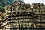
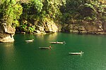
From top, left to right: Sela Pass, Loktak Lake, Kolodyne castle, Unakoti stone relief, Kaziranga National Park, Umngot River, Dzukou Valley, Kangchenjunga
Coordinates: 26°N91°E / 26°N 91°E / 26; 91
Country
India
States
Arunachal Pradesh
Assam
Manipur
Meghalaya
Mizoram
Nagaland
Tripura
Sikkim
Largest city
Guwahati
Major cities (2011 Census of India)[1]
Agartala
Imphal
Dimapur
Shillong
Aizawl
Silchar
Dibrugarh
Jorhat
Nagaon
Area
• Total
262,184 km2 (101,230 sq mi)
Population
(2011)
• Total
45,772,188
• Estimate
(2022)[2]
51,670,000
• Density
173/km2 (450/sq mi)
Time zone
UTC+5:30 (Indian Standard Time)
Scheduled languages
Assamese[3]
Bengali[3]
Bodo[3]
Meitei (Manipuri)[3][4]
Nepali[3]
State/Regional official languages
Assamese (of Assam)[5][6]
Bengali (of Tripura[5][7][8] and Barak Valley[5][9])
Bodo (of Bodoland)[5][10][11]
Kokborok (Tripuri) (of Tripura)[5][7][8]
Mizo (of Mizoram)[5][12]
Meitei (Manipuri) (of Manipur[5][12][13][14] and Assam[15][16]
Nepali (of Sikkim)[17]
English (of Arunachal Pradesh, Meghalaya and Nagaland)[5]
Sikkimese (of Sikkim)[17]
Northeast India, officially known as the North Eastern Region (NER), is the easternmost region of India representing both a geographic and political administrative division of the country.[18] It comprises eight states—Arunachal Pradesh, Assam, Manipur, Meghalaya, Mizoram, Nagaland and Tripura (commonly known as the "Seven Sisters"), and the "brother" state of Sikkim.[19]
The region shares an international border of 5,182 kilometres (3,220 mi) (about 99 per cent of its total geographical boundary) with several neighbouring countries – 1,395 kilometres (867 mi) with China in the north, 1,640 kilometres (1,020 mi) with Myanmar in the east, 1,596 kilometres (992 mi) with Bangladesh in the south-west, 97 kilometres (60 mi) with Nepal in the west, and 455 kilometres (283 mi) with Bhutan in the north-west.[20] It comprises an area of 262,184 square kilometres (101,230 sq mi), almost 8 per cent of that of India. The Siliguri Corridor connects the region to the rest of mainland India.
The states of North Eastern Region are officially recognised under the North Eastern Council (NEC),[19] constituted in 1971 as the acting agency for the development of the north eastern states. Long after induction of NEC, Sikkim formed part of the North Eastern Region as the eighth state in 2002.[21][22] India's Look-East connectivity projects connect Northeast India to East Asia and ASEAN. The city of Guwahati in Assam is referred to as the "Gateway to the Northeast" and is the largest metropolis in Northeast India.
^"Indian cities by population" (PDF). Archived (PDF) from the original on 23 July 2013. Retrieved 30 May 2018.
^State/UT wise Aadhaar Saturation
^ abcde"Languages Included in the Eighth Schedule of the Indian Constitution | Department of Official Language | Ministry of Home Affairs | GoI". rajbhasha.gov.in. Retrieved 31 July 2022.
^"Manipuri language | Britannica". www.britannica.com. 25 February 2024.
^ abcdefgh"Report of the Commissioner for linguistic minorities: 47th report (July 2008 to June 2010)" (PDF). Commissioner for Linguistic Minorities, Ministry of Minority Affairs, Government of India. pp. 84–89. Archived from the original (PDF) on 13 May 2012. Retrieved 16 February 2012.
^Nath, Monoj Kumar (29 March 2021). The Muslim Question in Assam and Northeast India. Taylor & Francis. p. 57. ISBN 978-1-000-37027-0.
^ abChakravarti, Sudeep (6 January 2022). The Eastern Gate: War and Peace in Nagaland, Manipur and India's Far East. Simon and Schuster. p. 421. ISBN 978-93-92099-26-7.
^ abKumāra, Braja Bihārī (2007). Problems of Ethnicity in the North-East India. Concept Publishing Company. p. 88. ISBN 978-81-8069-464-6.
^Wadley, Susan S. (18 December 2014). South Asia in the World: An Introduction: An Introduction. Routledge. p. 76. ISBN 978-1-317-45959-0.
^Oinam, Bhagat; Sadokpam, Dhiren A. (11 May 2018). Northeast India: A Reader. Taylor & Francis. p. 164. ISBN 978-0-429-95320-0.
^Deb, Bimal J. (2006). Ethnic Issues, Secularism, and Conflict Resolution in North East Asia. Concept Publishing Company. p. 21. ISBN 978-81-8069-134-8.
^ abBritannica. Student Britannica India 7 Vols. Popular Prakashan. p. 174. ISBN 978-0-85229-762-9.
^Brenzinger, Matthias (31 July 2015). Language Diversity Endangered. Walter de Gruyter GmbH & Co KG. p. 322. ISBN 978-3-11-090569-4.
^Experts, Arihant (4 June 2019). General Knowledge 2020. Arihant Publications India limited. p. 531. ISBN 978-93-131-9167-4.
^Purkayastha, Biswa Kalyan (24 February 2024). "Assam recognises Manipuri as associate official language in four districts". Hindustan Times. Retrieved 26 February 2024.
^PTI (24 February 2024). "Assam Cabinet gives nod to recognise Manipuri as associate official language in four districts". The Hindu. ISSN 0971-751X. Retrieved 26 February 2024.
^ abLegislative assembly
^"Home ,Ministry of Development of North Eastern Region, North East India". mdoner.gov.in. Retrieved 10 September 2023.
^ ab"North Eastern Council". Archived from the original on 15 April 2012. Retrieved 25 March 2012.
^"Problems of border areas in Northeast India" (PDF). Archived (PDF) from the original on 23 January 2022. Retrieved 30 April 2018.
^Cite error: The named reference Integration of Sikkim in North Eastern Council was invoked but never defined (see the help page).
^"Evaluation of NEC funded projects in Sikkim" (PDF). NEC. Archived from the original (PDF) on 8 September 2017. Retrieved 4 June 2017.
NortheastIndia, officially known as the North Eastern Region (NER), is the easternmost region of India representing both a geographic and political administrative...
The Insurgency in NortheastIndia involves multiple separatist militant groups operating in some of India's northeastern states, which are connected to...
NortheastIndia consists of eight states: Arunachal Pradesh, Assam, Manipur, Meghalaya, Mizoram, Nagaland, Sikkim and Tripura. Tourism in this area is...
in NortheastIndia involve multiple armed separatist factions operating in India's northeastern states, which are connected to the rest of India by the...
the inaugural season of Indian Super League. NorthEast United represents the 8 states of North East India, consisting of Assam, Nagaland, Manipur, Meghalaya...
NortheastIndia, the easternmost region of India, refers to the states of Arunachal Pradesh, Assam, Manipur, Meghalaya, Mizoram, Nagaland, Tripura, and...
in Jammu and Kashmir and in NortheastIndia. It has unresolved territorial disputes with China and with Pakistan. India's sustained democratic freedoms...
The hill tribes of NortheastIndia are hill people, mostly classified as Scheduled Tribes (STs), who live in the NortheastIndia region. This region has...
longest bridge in India that connects Mumbai with Navi Mumbai. 14 January - Bharat Jodo Nyay Yatra by Rahul Gandhi commences in NortheastIndia. 22 January...
Border disputes of NortheastIndia mainly include inter-state conflict between Assam–Mizoram, Assam–Arunachal Pradesh, Assam–Nagaland and Assam–Meghalaya...
members of the British East India Company, who were trading with Tamil merchants along the Coromandel Coast of southeast India, becoming known as a "spice...
BCE 200 -CE 1200 Assam (NortheastIndia): Pre-literary to Historical and Early Medieval Periods". Archaeology in NortheastIndia Recent Trends and Future...
Medieval India refers to a long period of post-classical history of the Indian subcontinent between the "ancient period" and "modern period". It is usually...
more ICP, Oct 2016. India opens two border crossing points with Myanmar, Bangladesh, Times of India, 1 Oct 2017. India'snortheast opened up Archived 2018-11-27...
the Uniform Civil Code, especially from NortheastIndia, claiming that it will go against the "idea of India" and will end special privileges of tribal...
Mainland India is a geo-political term sometimes used to refer to India excluding the region of NortheastIndia, with the two regions connected by the...
Greater Guwahati Metropolitan Area. Guwahati is the largest city in NortheastIndia. The Guwahati region hosts diverse wildlife including rare animals...
19th century, the British India forces began expanding their influence in NortheastIndia, including the Naga Hills. After India's independence in 1947, the...
Guwahati". 6 July 2023. "Upcoming Elections in India 2023-24". 26 July 2023. "BJP leaders of eastern, Northeast States meet in Guwahati; 142 Lok Sabha seats...
in NortheastIndia, along with number of churches and approximate number of Church members. Church of North India (CNI) Diocese of NortheastIndia (275)...
Kutch salt marshes. In the far northeast, the Chin Hills and Kachin Hills, deeply forested mountainous regions, separate India from Burma. On the east, its...
new years in parts of India where the sun's path is followed, such as in states like Tamil Nadu, Odisha, Bengal, NortheastIndia, Punjab, Haryana, Uttarakhand...
distinct, recognisable languages in the New Indo-Aryan Age. In the NortheastIndia, among the Sino-Tibetan languages, Meitei language (officially known...
April 2024). "ABP-CVoter Opinion Poll: BJP Set To Reign Supreme In Northeast, INDIA Faces Washout". news.abplive.com. Retrieved 17 April 2024. "BJP-led...
to the Seven Sister States of NortheastIndia by the narrow Siliguri Corridor in the north east of West Bengal. East India has the fourth-largest gross...
South India, particularly in Kerala, Tamil Nadu and Goa. There are also large Christian populations in NortheastIndia. Christianity in India was expanded...
 Global Information