 Global Information
Administrative divisions of Nicosia information
Nicosia within the city limits is divided into 29 administrative units, according to the latest census. This unit is termed in English as quarter, neighbourhood, parish, enoria or mahalla. These units are: Ayios Andreas (former name: Tophane), Trypiotis, Nebethane, Tabakhane, Phaneromeni, Ayios Savvas, Omerie, Ayios Antonios (St. Anthony), St. John, Taht-el-kale, Chrysaliniotissa, Ayios Kassianos (Kafesli), Kaïmakli, Panayia, St Constantine & Helen, Ayioi Omoloyites, Arab Ahmet, Yeni Jami, Omorfita, Ibrahim Pasha, Mahmut Pasha, Abu Kavouk, St. Luke, Abdi Chavush, Iplik Pazar and Korkut Effendi, Ayia Sophia, Haydar Pasha, Karamanzade,[1] and Yenişehir/Neapolis (separated from Ibrahim Pasha 25 January 2010[2]). Some of these units were previously independent Communities (village authorities). Ayioi Omoloyites was annexed in 1944, while Kaïmakli and Omorfita were annexed in 1968. Pallouriotissa, also annexed in 1968, was subsequently divided into the neighbourhoods of Panayia, and St Constantine & Helen.[3]
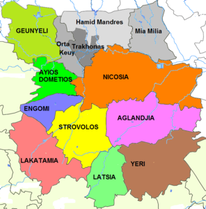
The municipality of Strovolos, established in 1986, is the second largest municipal authority in Cyprus in terms of population after Limassol and encompasses the southern suburbs of the capital immediately adjacent to Nicosia municipality. Strovolos is divided into six parishes: Chryseleousa, Ayios Demetrios, Apostle Barnabas and Ayios Makarios, Ayios Vasilios, Kyprianos and Stavros.[4]
Beyond Strovolos on the south-western fringes of the metropolis lies the municipality of Lakatamia, created in 1986 out of the two Communities (village authorities) of Lower Lakatamia and Upper Lakatamia. After being declared a municipality Lakatamia was, for administrative purposes, divided into the following four parishes: Ayia Paraskevis, St. Nicholas, Ayios Mamas, Archangel-Anthoupolis. Contrary to other Municipalities, Lakatamia Municipality has its own water supply (Lakatamia Water Board). It has jurisdiction over the water supply and sees to the construction, maintenance and functioning of water supply systems within its boundaries.[5]
South of Strovolos lies the municipality of Latsia, established in 1986. Latsia is divided into three parishes: St. George (covering most of the area of Latsia), Ayios Eleftherios (covering the Ayios Eleftherios refugee housing estate) and Archangel Michael (covering the refugee self-housing estate of that name).[6]
East of Latsia lies Yeri, which became a municipality in 2011. The built up area of Yeri just touches Latsia near their mutual boundary and thus the new municipality is conurbated with Nicosia.
The municipality of Aglandjia, established in 1986, encompasses the south-eastern suburbs of the capital immediately adjacent to Nicosia municipality. The Nicosia-Limassol highway forms the boundary with Strovolos to the west. The name of the municipality has various spellings, but derives from the Turkish word 'Eğlence - Entertainment'. The older English spelling is Eylenja.[7]
The western suburbs are encompassed in the municipalities of Ayios Dometios and Engomi, both established in 1986. The municipality of Ayios Dometios is divided into the parishes of St. George and St. Paul.
The town of Gönyeli is now conurbated with the northern suburbs. Previously a village authority, it now functions as a municipality[8] within the same area[9] Gönyeli is divided into the Neighbourhoods of Baraj (barrage), Çarşı, Baz and Yeni Kent (new town).[10]
The suburbs immediately to the north of the city have not been erected into municipalities. The village authority of Hamitköy (also known as Hamid Mandres) was heavily urbanized[11] and continued to exist until 1 September 2008, when it was included within the borders of Nicosia Turkish Municipality[12] as a Nicosia neighbourhood headed by a muhtar.[13]
Ortakeuy Village authority[14] has similarly been redefined as a neighbourhood of Nicosia Turkish Municipality.
After the invasion the Greek Cypriot inhabitants of Mia Milia were displaced to other parts of Cyprus and the area was resettled by displaced Turkish Cypriots from other areas.[15] The Mia Milia Village Council of the Republic of Cyprus continues to operate in exile,[16] but the Nicosia Turkish Municipality considers it one of its neighbourhoods.[17]
The ethnically mixed Village of Trakhonas has suffered several displacements of both its Greek and Turkish Cypriot inhabitants since the 1960s and since the invasion has been heavily urbanised.[18] It does not currently function as a local government unit[19]
The settlement of Anthoupolis is an enclave created within Lakatamia after the invasion of 1974 and is directly administered by the government and not the municipality within which it is situated.
| Code | Name | Loc. auth. |
CY Pop. 2011 |
TC Pop. 2011 |
CY Ctrl. |
TC Ctrl. |
Pop. 1946 |
GC 1946 |
TC 1946 |
On map |
|---|---|---|---|---|---|---|---|---|---|---|
| 1000 | Nicosia | Mun | 55,014 | 49,868 | P | P | 34,485 | 60% | 30% | |
| 1000-01 | Ayios Andreas (Tophane) | Neigh | 5,767 | Y | 3,012 | 74% | 5% | AA/T | ||
| 1000-02 | Trypiotis | Neigh | 2,158 | Y | 3,247 | 92% | 1% | Try | ||
| 1000-03 | Nebethane | Neigh | 189 | Y | 520 | 84% | 4% | Ne | ||
| 1000-04 | Tabakhane | Neigh | 299 | Y | 757 | 93% | 3% | TH | ||
| 1000-05 | Phaneromeni | Neigh | 512 | Y | 1,088 | 98% | 1% | Ph | ||
| 1000-06 | Ayios Savvas | Neigh | 581 | Y | 1,266 | 96% | 3% | ASa | ||
| 1000-07 | Omerie | Neigh | 206 | Y | 1,193 | 77% | 21% | Om | ||
| 1000-08 | Ayios Antonios | Neigh | 5,801 | Y | 2,090 | 98% | 0% | AAn | ||
| 1000-09 | Ayios Ioannis | Neigh | 221 | Y | 1,436 | 96% | 4% | AI | ||
| 1000-10 | Taht-el-kale | Neigh | 826 | Y | 1,433 | 63% | 36% | TEK | ||
| 1000-11 | Chrysaliniotissa | Neigh | 124 | Y | 901 | 96% | 3% | Ch | ||
| 1000-12 | Ayios Kassianos (Kafesli) | Neigh | 82 | P | P | 1,177 | 90% | 10% | AKs | |
| 1000-13 | Kaimakli | Neigh | 11,564 | P | Un | 3,671 | 98% | 2% | ||
| 1000-14 | Panayia[24] | Neigh | 12,398 | Y | 2,368 | 98% | 2% | |||
| 1000-15 | St. Constantine & Helen[24] | Neigh | 3,209 | Y | ||||||
| 1000-16 | Ayioi Omoloyites | Neigh | 10,528 | Y | 1,810 | 93% | 1% | |||
| 1000-17 | Arab Ahmet | Neigh | 50 | P | S | 2,617 | 22% | 32% | AA[25] | |
| 1000-18 | Yeni Jami | Neigh | 215 | P | S | 2,345 | 28% | 72% | YJ | |
| 1000-19 | Omorfita | Neigh | 284 | P | P | 2,231 | 55% | 45% | ||
| 1000-20 | Ibrahim Pasha[2][26] | Neigh | Y | 2,334 | 28% | 66% | IP | |||
| 1000-21 | Mahmut Pasha | Neigh | 314[23] | Y | 875 | 7% | 82% | MP | ||
| 1000-22 | Abu Kavouk | Neigh | 793[23] | Y | 1,202 | 9% | 91% | AK (North) | ||
| 1000-23 | St. Luke | Neigh | 489[23] | Y | 806 | 33% | 67% | AL | ||
| 1000-24 | Abdi Chavush | Neigh | 568[23] | Y | 902 | 8% | 89% | AC | ||
| 1000-25 | Iplik Bazar & Korkut Effendi | Neigh | 229[23] | Y | 556 | 21% | 42% | IPKE | ||
| 1000-26 | Ayia Sophia | Neigh | 878[23] | P | P | 1,936 | 33% | 64% | ASo | |
| 1000-27 | Haydar Pasha | Neigh | 155[23] | Y | 385 | 12% | 87% | HP | ||
| 1000-28 | Karamanzade | Neigh | P | P | 597 | 21% | 10% | KZ | ||
| 1000-29 | Neapoli[2][26] | Neigh | Y | IP | ||||||
| 1010 | Ayios Dometios | Mun | 12,456 | P | P | 2,532 | 95% | 5% | ||
| 1011 | Engomi | Mun | 18,010 | Y | 1,396 | 100% | 0% | |||
| 1012 | Strovolos | Mun | 67,904 | Y | 3,214 | 98% | 2% | |||
| 1013 | Aglandjia | Mun | 20,783 | P | Un | 2,008 | 93% | 7% | ||
| 1014 | Ortakeuy | Vill | Y[27] | 477 | 12% | 88% | ||||
| 1015 | Trachonas | Vill | M[28] | 690 | 95% | 5% | ||||
| 1021 | Lakatameia | Mun | 38,345 | Y | 1,537 | 94% | 6% | |||
| 1022 | Anthoupolis[29] | Set | 1,756 | Y | ||||||
| 1023 | Latsia | Mun | 16,774 | Y | 179 | 100% | 0% | |||
| 1024 | Yeri | Mun | 8,235 | P | Un | 655 | 100% | 0% | ||
| 1031 | Mia Milia | Vill | Y | 772 | 100% | 0% | ||||
| 1032 | Hamitköy | Vill | 2,823 | Y | 361 | 0% | 100% | |||
| 1251 | Gönyeli | Mun | 11,964 | Ind | 814 | 0% | 100% | |||
|
Code: census code. | ||||||||||
- ^ Census of Cyprus (available from Statistical Service, Nicosia). Document: Population - Place of Residence, 2011, Table C. Municipality/Community, Quarter and Street Index published by Ministry of Information (CILIS_streets_022011)
- ^ a b c Official Gazette of the Republic No. 4341 and dated 25.01.2010
- ^ Official web site of Nicosia municipality http://www.nicosia.org.cy and https://www.scribd.com/doc/Οι-ενορίες-της-Λευκωσίας
- ^ Official web site of Strovolos municipality, history section (English version), http://www.strovolos.org.cy
- ^ Official web site of Lakatamia municipality, history section (English version), http://www.lakatamia.org.cy
- ^ Official web site of Latsia municipality, history section (English version), http://www.latsia.org.cy
- ^ Official web site of municipality "Untitled Document". Archived from the original on 2008-11-20. Retrieved 2015-03-22.
- ^ Municipal web site, August 2013: www.gonyeli.org/
- ^ The authority has the population, economic viability and consent of the (original) inhabitants prescribed in the Municipalities Law (see Law 11/1985), without having been formally recognised as a municipality under that law. See also www.prio-cyprus-displacement.net/default_print.asp?id=300 retrieved August 2013
- ^ See Municipal web site and postcode publication tk cyp Posta Kodları.pdf (May 2013)
- ^ "PRIO". prio-cyprus-displacement.net. Retrieved 22 March 2015.
- ^ [1] (retrieved August 2013)
- ^ "Haber Arşivi". Archived from the original on 2014-05-18. Retrieved 2015-03-22. retrieved August 2013
- ^ "PRIO". prio-cyprus-displacement.net. Retrieved 22 March 2015.
- ^ *"PRIO". prio-cyprus-displacement.net. Archived from the original on 12 October 2018. Retrieved 22 March 2015. (August 2013)
- ^ "Μια Μηλιά Λευκωσίας". Archived from the original on 2015-01-26. Retrieved 2015-03-22. (retrieved August 2013)
- ^ "Haber Arşivi". Archived from the original on 2014-05-18. Retrieved 2015-03-22.
- ^ "PRIO". prio-cyprus-displacement.net. Retrieved 22 March 2015.
- ^ Nicosia Turkish Municipality treats it as four neighbourhoods, see www.lefkosaturkbelediyesi.org/turkce/muhtarlar.htm
- ^ Coexistence in the Disappeared Mixed Neighbourhoods of Nicosia, by Ahmet An (Paper read at the conference, “Nicosia: The Last Divided Capital in Europe”, organized by the London Metropolitan University on 20 June 2011)
- ^ "Population Enumerated by Sex, Age, District, Municipality/Community and Quarter, 2011 – (2011 Census of the Republic of Cyprus, Statistical Service)" (in Greek). Mof.gov.cy. Retrieved 21 July 2012.
- ^ 6th edition of the publication “Statistical Codes of Municipalities, Communities and Quarters of Cyprus” (publ. Statistical Service of Republic of Cyprus); Census of Cyprus 1946; List of Mahalla Mukhtars publ.by Nicosia Turkish Municipality
- ^ a b c d e f g h Census organised by the Turkish Cypriots in the occupied area "Archived copy" (PDF). Archived from the original (PDF) on 2013-11-06. Retrieved 2014-09-16.
{{cite web}}: CS1 maint: archived copy as title (link) retrieved October 2013 - ^ a b Pallouriotissa was split into Panaya and St. Constantine & Helen after 1968.
- ^ Keushk Chiftlik (Kösklüçiftlik) is the area outside of the walls in Nicosia Turkish Municipality
- ^ a b The neighborhood of Neapoli was separated from the neighborhood of Ibrahim Pasha 25 January 2010.
- ^ Small part in Göçmenköy neighbourhood
- ^ Divided into 4 new neighbourhoods
- ^ The settlement of Anthoupolis is an enclave created within the municipality of Lakatameia after 1974.
- ^ "TRNC General Population and Housing Unit Census – (TRNC State Planning Organisation)" (PDF). Archived from the original (PDF) on 16 January 2013. Retrieved 21 July 2012.