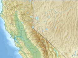
The Yolo Bypass is one of the two flood bypasses in California's Sacramento Valley located in Yolo and Solano Counties.[1] Through a system of weirs, the bypass diverts floodwaters from the Sacramento River away from the state's capital city of Sacramento and other nearby riverside communities.[2]
During wet years, the bypass can be full of water. The main input to the bypass is through the passive Fremont Weir, where water spills from the Sacramento into the bypass if it reaches the 33.5 feet (10.2 m) crest. Downstream, the Sacramento Weir, just north of the city of West Sacramento, can also be opened to divert additional waters from the Sacramento if needed. From the west, Cache Creek drains into the bypass. The bypass itself runs south, parallel to the Sacramento, and drains into the Sacramento-San Joaquin Delta, a few miles north of Rio Vista.
The bypass is crossed by the Yolo Causeway, a long highway bridge on Interstate 80, linking West Sacramento and the city of Davis, as well as by a rail causeway just north of the Yolo Causeway used by freight and Amtrak trains. To the north, Interstate 5 also crosses the bypass on the Elkhorn Causeway, east of the city of Woodland.
^"A Framework for the Future: Yolo Bypass Management Strategy" (PDF). Yolo Bypass Working Group, Yolo Basin Foundation, and Jones & Stokes. August 2001. Retrieved June 28, 2018.
^Tokita, Joyce; Cameron-Harley, Jamie. "Beneath the Flood". California Department of Water Resources. Retrieved February 28, 2009.
The YoloBypass is one of the two flood bypasses in California's Sacramento Valley located in Yolo and Solano Counties. Through a system of weirs, the...
Look up YOLO or Yolo in Wiktionary, the free dictionary. Yolo or YOLO may refer to: YOLO (aphorism) ("you only live once") Yolo, California, an unincorporated...
The Yolo Causeway is a 3.2-mile (5.1 km) long elevated highway viaduct on Interstate 80 that crosses the YoloBypass floodplain, connecting the cities...
The YoloBypass Wildlife Area, located within the YoloBypass in Yolo County, California, is managed by the California Department of Fish and Wildlife...
Liwaito) is a major stream in Northern California, a tributary of the YoloBypass, and ultimately, the Sacramento River. The 85-mile-long (137 km) creek...
are now intercepted by the YoloBypass via man-made channels. The main channel of the Sacramento flows south, forming the Yolo–Sacramento County line. As...
acres (591 ha) at the north end of the YoloBypass floodway along the Sacramento River in Sutter County and Yolo County. It is 6 miles north-east of the...
within the YoloBypass Wildlife Area located in the YoloBypass in Yolo County, California, between the cities of Sacramento and Davis. The Yolo Causeway...
tunnels, floods, and fire, etc., California State Capitol, Wine Country, YoloBypass Wildlife Area, Cosumnes River Preserve, Hawver Cave with a lake inside...
Westham Island off Richmond, British Columbia Vic Fazio Yolo Wildlife Area in the YoloBypass in the Central Valley of California. Klamath Basin National...
Sutter Bypass Tehama Truckee River Upper Butte Basin Volta Warner Valley Waukell Creek West Hilmar Westlker River White Slough Willow Creek YoloBypass Ecological...
Sutter Bypass Tehama Truckee River Upper Butte Basin Volta Warner Valley Waukell Creek West Hilmar Westlker River White Slough Willow Creek YoloBypass Ecological...
Sutter Bypass Tehama Truckee River Upper Butte Basin Volta Warner Valley Waukell Creek West Hilmar Westlker River White Slough Willow Creek YoloBypass Ecological...
Area in Yolo County along the south side of UC Davis and after passing through the city of Davis, it crosses the YoloBypass (a major flood bypass for Sacramento)...
Sutter Bypass Tehama Truckee River Upper Butte Basin Volta Warner Valley Waukell Creek West Hilmar Westlker River White Slough Willow Creek YoloBypass Ecological...
Sutter Bypass Tehama Truckee River Upper Butte Basin Volta Warner Valley Waukell Creek West Hilmar Westlker River White Slough Willow Creek YoloBypass Ecological...
acres (119 ha) of the redwood forest to the federal government, thus bypassing the local courts. Muir Woods became a national monument in 1908 before...
Sutter Bypass Tehama Truckee River Upper Butte Basin Volta Warner Valley Waukell Creek West Hilmar Westlker River White Slough Willow Creek YoloBypass Ecological...
Sutter Bypass Tehama Truckee River Upper Butte Basin Volta Warner Valley Waukell Creek West Hilmar Westlker River White Slough Willow Creek YoloBypass Ecological...
Sutter Bypass Tehama Truckee River Upper Butte Basin Volta Warner Valley Waukell Creek West Hilmar Westlker River White Slough Willow Creek YoloBypass Ecological...
Sutter Bypass Tehama Truckee River Upper Butte Basin Volta Warner Valley Waukell Creek West Hilmar Westlker River White Slough Willow Creek YoloBypass Ecological...
Sutter Bypass Tehama Truckee River Upper Butte Basin Volta Warner Valley Waukell Creek West Hilmar Westlker River White Slough Willow Creek YoloBypass Ecological...
Plant (1971) Silverwood Lake Lake Perris Sutter Bypass Tisdale Weir Tisdale Bypass Sacramento Weir YoloBypass Antelope Dam (1964) The following is a list...
Sutter Bypass Tehama Truckee River Upper Butte Basin Volta Warner Valley Waukell Creek West Hilmar Westlker River White Slough Willow Creek YoloBypass Ecological...
 Global Information