 Global Information
Sacramento River information
| Sacramento River Rio del Santísimo Sacramento | |
|---|---|
 Sacramento River from the old pumping station in Sacramento, California | |
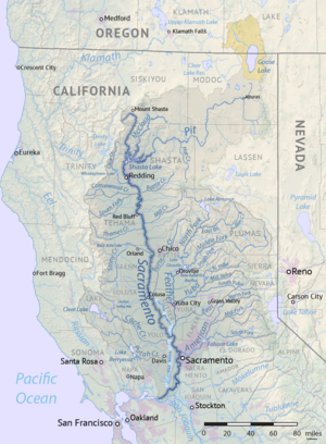 Map of the Sacramento River watershed | |
| Native name | Río Sacramento (Spanish) |
| Location | |
| Country | United States |
| State | California |
| Cities | Mount Shasta, Dunsmuir, Redding, Anderson, Red Bluff, Princeton, Colusa, Davis, Sacramento, West Sacramento, Isleton, Rio Vista, Antioch |
| Physical characteristics | |
| Source | Confluence of Middle and South Forks |
| • location | Near Mount Shasta, Siskiyou County |
| • coordinates | 41°16′24″N 122°24′05″W / 41.27333°N 122.40139°W[1] |
| • elevation | 3,674 ft (1,120 m)[2] |
| Mouth | Suisun Bay |
• location | Contra Costa-Solano county line |
• coordinates | 38°03′48″N 121°51′10″W / 38.06333°N 121.85278°W[1] |
• elevation | 0 ft (0 m) |
| Length | 400 mi (640 km), North-south[3] |
| Basin size | 26,500 sq mi (69,000 km2)[4] |
| Discharge | |
| • location | near Sacramento, CA[5][6][7] |
| • average | 28,139 cu ft/s (796.8 m3/s)[6][7] |
| • minimum | 3,970 cu ft/s (112 m3/s)[6] |
| • maximum | 489,000 cu ft/s (13,800 m3/s)[6][7] |
| Basin features | |
| Tributaries | |
| • left | Pit River, Deer Creek, Butte Creek, Feather River, American River |
| • right | Clear Creek, Cottonwood Creek, Stony Creek, Cache Creek, Putah Creek |
| Nicknames | Sac River, Nile of the West[8] |
The Sacramento River (Spanish: Río Sacramento) is the principal river of Northern California in the United States and is the largest river in California.[9] Rising in the Klamath Mountains, the river flows south for 400 miles (640 km) before reaching the Sacramento–San Joaquin River Delta and San Francisco Bay. The river drains about 26,500 square miles (69,000 km2) in 19 California counties, mostly within the fertile agricultural region bounded by the Coast Ranges and Sierra Nevada known as the Sacramento Valley, but also extending as far as the volcanic plateaus of Northeastern California. Historically, its watershed has reached as far north as south-central Oregon where the now, primarily, endorheic (closed) Goose Lake rarely experiences southerly outflow into the Pit River, the most northerly tributary of the Sacramento.
The Sacramento and its wide natural floodplain were once abundant in fish and other aquatic creatures, notably one of the southernmost large runs of chinook salmon in North America. For about 12,000 years, humans have depended on the vast natural resources of the watershed, which had one of the densest Native American populations in California. The river has provided a route for trade and travel since ancient times. Hundreds of tribes sharing regional customs and traditions have inhabited the Sacramento Valley, first coming into contact with European explorers in the late 1700s. The Spanish explorer Gabriel Moraga named the river Rio de los Sacramentos in 1808, later shortened and anglicized into Sacramento.
In the 19th century, gold was discovered on a tributary of the Sacramento River, starting the California Gold Rush and an enormous population influx to the state. Overland trails such as the California Trail and Siskiyou Trail guided hundreds of thousands of people to the gold fields. By the late part of the century mining had ceased to be a major part of the economy, and many immigrants turned to farming and ranching. Many populous communities were established along the Sacramento River, including the state capital of Sacramento. Intensive agriculture and mining contributed to pollution in the Sacramento River, and significant changes to the river's hydrology and environment.
Since the 1950s the watershed has been intensely developed for water supply and the generation of hydroelectric power. Today, large dams impound the river and almost all of its major tributaries. The Sacramento River is used heavily for irrigation and serves much of Central and Southern California through the canals of giant state and federal water projects. While it is now providing water to over half of California's population and supporting the most productive agricultural area in the nation, these changes have left the Sacramento greatly modified from its natural state and have caused the decline of its once-abundant fisheries.
- ^ a b "Sacramento River". Geographic Names Information System. United States Geological Survey, United States Department of the Interior. January 19, 1981. Retrieved August 27, 2010.
- ^ "South Fork Sacramento River". Geographic Names Information System. United States Geological Survey, United States Department of the Interior. January 19, 1981. Retrieved August 27, 2010.
- ^ Benke and Cushing, p. 547
- ^ "Boundary Descriptions and Names of Regions, Subregions, Accounting Units and Cataloging Units". U.S. Geological Survey. Archived from the original on April 27, 2012. Retrieved August 22, 2010.
- ^ Discharge figure is a combination of USGS gage 11447650 Sacramento River at Freeport and USGS 11453000 Yolo Bypass near Woodland. Flood flows diverted around the Sacramento area via the Sacramento River Flood Control Project are recorded by the Yolo Bypass gage.
- ^ a b c d Cite error: The named reference
Freeport-dischargewas invoked but never defined (see the help page). - ^ a b c Cite error: The named reference
Yolo-bypass-dischargewas invoked but never defined (see the help page). - ^ Angel, Devanie (December 5, 2002). "The 'reasonable' environmentalist: When John Merz talks about the Sacramento River, people listen". Chico News & Review. Sacramento River Preservation Trust. Archived from the original on September 2, 2004. Retrieved September 5, 2010.
- ^ Carter, James and Resh, Vincent (June 9, 2005). "Pacific Coast Rivers of the Coterminous United States". In Benke, Arthur and Colbert Cushing (ed.). Rivers of North America. Elsevier. pp. 547–552. ISBN 0120882531.
{{cite book}}: CS1 maint: multiple names: authors list (link)