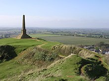
The Yeovil Scarplands are a natural region in southern England in the counties of Somerset and Dorset.
The region is listed as National Character Area 140 by Natural England, the UK Government's advisor on the natural environment. It covers 78,579 hectares (303.40 sq mi) and runs from Chard in the southwest to Chesterblade and Upton Noble in the northeast. The town of Yeovil lies roughly in the centre of the area. To the west are the Blackdowns and the Vale of Taunton and Quantock Fringes, to the north are the Mid Somerset Hills and the Mendips, to the east are the Blackmoor Vale and Vale of Wardour and to the south, the Marshwood and Powerstock Vales and Dorset Downs.[1][2]
With a predominantly rural landscape, Yeovil and other urban areas occupying less than 5% of the area, about 85% is farmed and the remainder predominantly pastoral.[3] The area is drained by several rivers including: River Axe, River Brue, River Cary, River Isle, River Parrett, River Yeo and the Whitelake River.
The area includes Neolithic hill forts, remains of Roman villas and many listed buildings. The area also includes 9477 ha of the Area of Outstanding Natural Beauty.
^NCA 140: Yeovil Scarplands - Key Facts & Data at www.naturalengland.org.uk. Accessed on 6 Apr 2013.
^Yeovil Scarplands - Character Area 140 at www.naturalengland.org.uk. Accessed on 6 Apr 2013.
^Updated NCA Profile:140 Yeovil Scarplands (NE557) at www..naturalengland.org.uk Upload from 24 April 2014 accessed 2 Nov 2014.
The YeovilScarplands are a natural region in southern England in the counties of Somerset and Dorset. The region is listed as National Character Area...
Bristol and 30 miles (48 km) from Taunton. It lies in the centre of the YeovilScarplands, a natural region of England. The suburbs include Summerlands, Hollands...
west, the Blackdowns to the southwest, the Mid Somerset Hills and YeovilScarplands to the southeast, the Mendip Hills to the east and the Bristol, Avon...
metres (702 ft) high, just north of the village of Broadwindsor in the YeovilScarplands, in the county of Dorset in southern England. It has a prominence...
Exmoor, the Vale of Taunton and Quantock Fringes, the Blackdowns, the YeovilScarplands and the Marshwood and Powerstock Vales. The Devon Redlands have a...
rise steeply from the flat landscape, to the east and south are the YeovilScarplands and to the southwest are the Blackdown Hills. The Mid Somerset Hills...
ridge, 204 metres (669 ft) high, on the Dorset-Somerset border in the YeovilScarplands in southwestern England. It has a prominence of 80 metres (260 ft)...
overlooks the valley of the River Axe and separates the region from the YeovilScarplands. To the east are the chalk hills of the Dorset Downs and Cranborne...
the west to Compton Chamberlayne in the east. To the west are the YeovilScarplands, to the north are the Mendip Hills and Avon Vales, to the south and...
trading centre, and is still a mainly industrial town. Yeovil is in the middle of the YeovilScarplands, an upland area on the southern borders of the county...
NW of Pilsdon Pen Conegar Hill 214 47 ST439032 TuMP Lewesdon Hill YeovilScarplands 500 m N of Broadwindsor Waddon Hill 213 35 ST448015 TuMP Lewesdon...
Fringes to the north, the Mid Somerset Hills to the northeast, the YeovilScarplands to the east and the Marshwood and Powerstock Vales to the southeast...
 Global Information