The Williston Basin is a large intracratonic sedimentary basin in eastern Montana, western North Dakota, South Dakota, southern Saskatchewan, and south-western Manitoba that is known for its rich deposits of petroleum and potash. The basin is a geologic structural basin but not a topographic depression; it is transected by the Missouri River. The oval-shaped depression extends approximately 475 miles (764 km) north-south and 300 miles (480 km) east-west.
The Williston Basin lies above an ancient Precambrian geologic basement feature, the Trans-Hudson Orogenic Belt that developed in this area about 1.8-1.9 billion years ago, and that created a weak zone that later led to sagging to produce the basin.[1] The Precambrian basement rocks in the center of the basin beneath the city of Williston, North Dakota lie about 16,000 feet (4,900 m) below the surface.
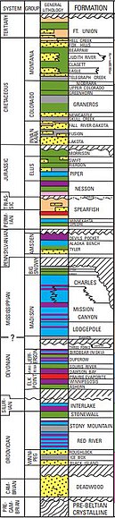
Stratigraphic column showing 12 hydrocarbon source beds and 15 reservoir rocks in the Williston Basin
Deposition of sediments began in the Williston area during Cambrian time, but subsidence and basin filling were most intense during the Ordovician, Silurian, and Devonian Periods, when thick accumulations of limestone and dolomite, with lesser thicknesses of sandstones, siltstones, shales, and evaporites were laid down. Subsidence continued on a reduced scale into the Mississippian and was largely ended by Pennsylvanian time. Regional subsidence returned during the Mesozoic Era, although total sediment thicknesses were much less than during the Paleozoic. Near the end of the Cretaceous, tectonic activity during the Laramide Orogeny rejuvenated several basement structures in the Williston Basin to produce anticlines that serve as oil traps today.[2]
^Gibson, R.I., 1995, Basement tectonics and hydrocarbon production in the Williston Basin: An interpretive overview: 7th Int'l. Williston Basin Symposium, 1995 Guidebook, p. 3-11
^Geologic Atlas of the Rocky Mountain Region, Rocky Mountain Association of Geologists, Denver, CO, 1972: p. 81-85, 88-89, 94-97, 168, 184
The WillistonBasin is a large intracratonic sedimentary basin in eastern Montana, western North Dakota, South Dakota, southern Saskatchewan, and south-western...
WillistonBasin International Airport (IATA: XWA, ICAO: KXWA, FAA LID: XWA) is an airport serving Williston, a city in the U.S. state of North Dakota...
WillistonBasin Pipeline is a natural gas pipeline system which moves gas between Wyoming, Montana, South Dakota, and North Dakota. It is owned by MDU...
in the WillistonBasin in North Dakota and Montana. It is organized in Delaware and headquartered in Houston, Texas, with an office in Williston, North...
Juan Basin, New Mexico and Colorado Uinta Basin, Utah WillistonBasin, Montana and North Dakota Wind River Basin, Wyoming Amadeus Basin Bowen Basin Cooper...
about 200,000 square miles (520,000 km2) of the subsurface of the WillistonBasin, underlying parts of Montana, North Dakota, Saskatchewan and Manitoba...
sedimentary basin even if it is no longer a bathymetric or topographic depression. The WillistonBasin, Molasse basin and Magallanes Basin are examples...
Williston State College (WSC) is a public community college in Williston, North Dakota. It is part of the North Dakota University System. Founded in 1961...
build WillistonBasin International Airport. Sloulin Field Airport closed to the public on October 10, 2019. The first airport to serve Williston, North...
presence in the Western Canadian Sedimentary Basin. The company's operations also include assets in the WillistonBasin in the United States. Crescent Point Energy...
billion. Petro-Hunt continues to operate in the WillistonBasin, Permian/Delaware Basins and other basins across the US. Hunt lived in Dallas, Texas, and...
Basin in Colorado and Utah; Stassfurt, Germany; the Perm Basin, Russia; and the WillistonBasin in Saskatchewan, Canada. These deposits date from the Devonian...
natural gas business following its discovery of oil in 1936 in the WillistonBasin in Eastern Montana. As it expanded across Eastern Montana and western...
WillistonBasin School District 7 (WBSD7) is a school district headquartered in Williston, North Dakota. In 2020 a vote was held on whether it was to...
Williston Lake is a reservoir created by the W. A. C. Bennett Dam and is located in the Northern Interior of British Columbia, Canada. The lake fills...
properties in the WillistonBasin in North Dakota for $1.4 billion. These assets, as well as other assets acquired by Oxy in the WillistonBasin, were sold in...
Three Forks Group is a stratigraphical unit of Famennian age in the WillistonBasin. It takes the name from the city of Three Forks, Montana, and was first...
crude oil from the Western Canadian Sedimentary Basin in Alberta, Canada, and from the WillistonBasin (Bakken) region in Montana and North Dakota, primarily...
Basin Safety Consulting Corporation is a health and safety company based in Williston, North Dakota. Positioned in the petroleum-rich WillistonBasin...
properties in the WillistonBasin of the Bakken Formation and the Turner, Parkman and Niobrara Formations in the Powder River Basin. The company also...
of the company's assets were in either the WillistonBasin (42% of 2019 production) or the Permian Basin (58% of 2019 production). Of the company's total...
sewage systems, and government services in the Bakken Formation and WillistonBasin area. For context, this area covers over half of the state. Some counties...
Willistonbasin. Journal of the Canadian Society of Exploration Geophysicists, v. 10, pp. 23–38. 1975 Sawatzky, H. B., Astroblemes in the Williston Basin...
for $846 million. In August 2013, the company acquired assets in the WillistonBasin for $260 million. In 2014, the company acquired Kodiak Oil & Gas. Kodiak...
After the discovery of oil in the WillistonBasin, Glendive became an oil boom town. The small reserves of the basin, coupled with the expense and difficulty...
 Global Information