 Global Information
West Branch Susquehanna River information
| West Branch Susquehanna River | |
|---|---|
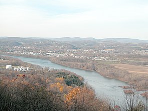 The eastern side of Williamsport seen from the southeast on Bald Eagle Mountain. In the foreground is the West Branch of the Susquehanna River. Beyond Williamsport can be seen the higher part of the dissected Allegheny Plateau. | |
 Map of the West Branch Susquehanna River watershed | |
| Location | |
| Country | United States |
| State | Pennsylvania |
| Region | Cambria County, Indiana County, Clearfield County, Clinton County, Centre County, Lycoming County, Northumberland County, Union County, Snyder County |
| Physical characteristics | |
| Source | Allegheny Mountains |
| • location | Near Carrolltown, Cambria County |
| • coordinates | 40°35′55″N 78°43′23″W / 40.59871°N 78.72311°W |
| Mouth | Susquehanna River |
• location | Northumberland, Northumberland County |
• coordinates | 40°52′55″N 76°47′51″W / 40.88194°N 76.79750°W[1] |
• elevation | 423 ft (129 m) |
| Length | 243 mi (391 km), West-east |
| Basin size | 6,847 sq mi (17,730 km2)[2] |
| Discharge | |
| • location | Lewisburg[2] |
| • average | 11,229 cu ft/s (318.0 m3/s)[2] |
| • maximum | 287,000 cu ft/s (8,100 m3/s)[3] |
| Basin features | |
| River system | Susquehanna River |
| Tributaries | |
| • left | Sinnemahoning Creek, Pine Creek, Larrys Creek, Lycoming Creek, Loyalsock Creek, Muncy Creek |
| • right | Chest Creek, Anderson Creek, Clearfield Creek, Bald Eagle Creek, White Deer Hole Creek |
The West Branch Susquehanna River is one of the two principal branches, along with the North Branch, of the Susquehanna River in the Northeastern United States. The North Branch, which rises in upstate New York, is generally regarded as the extension of the main branch,[4] with the shorter West Branch being its principal tributary.
The West Branch, which is 243 miles (391 km) long,[5] is entirely within the state of Pennsylvania, draining a large mountainous area within the Allegheny Plateau in the western part of the state. Along most of its course it meanders past mountain ridges and through water gaps, forming a large zigzag arc through central Pennsylvania around the north end of the Allegheny Mountains. In colonial times, the river valley provided an important route to the Ohio River valley. In the 19th century, its lower valley became a significant industrial heartland of Pennsylvania. In the 20th century, the upper reaches of the West Branch turned a yellow/orange color due to sulfurous drainage from nearby and abandoned deep bituminous coal mines.[citation needed]
- ^ "West Branch Susquehanna River". Geographic Names Information System. United States Geological Survey, United States Department of the Interior.
- ^ a b c "USGS Gage #1553500 on the West Branch Susquehanna River at Lewisburg (Avg)". National Water Information System. United States Geological Survey. Retrieved 2010-03-24.
- ^ "USGS Gage #1553500 on the West Branch Susquehanna River at Lewisburg (Peak)". National Water Information System. United States Geological Survey. Retrieved 2010-03-24.
- ^ U.S. Geological Survey Geographic Names Information System: Susquehanna River
- ^ "U.S. Geological Survey. National Hydrography Dataset high-resolution flowline data". viewer.nationalmap.gov. Retrieved August 8, 2011.