Global Information Lookup Global Information

Weser Depression information


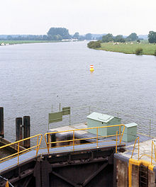
The Middle Weser near Drakenburg
Winter in Stedingen

The Weser Depression (German: Weserniederung) or Weser Lowlands is the region north of Porta Westfalica in Germany, where the River Weser no longer flows through a valley, but a broad plain consisting of meadows and river terraces.

The flat plain of the depression is interrupted by geest ridges in places. From Langwedel, as far as the River Lesum, it is separated from the Wümme Depression by a narrow ridge of dunes, on which the town of Achim and the older districts of the city of Bremen lie. At many places, such as south of the mouth of the River Aller or in Bremen-Huchting, the Weser Depression transitions to bog and marsh without any clear boundary. The southern part of the Weser Depression belongs to the state of North Rhine-Westphalia, with its towns of Minden and Petershagen. The borough of Petershagen includes Westphalia's northernmost Weser settlement, Schlüsselburg. North of that, the Weser passes the Low Saxon town of Stolzenau.

Below Hoya, the Weser reaches the Breslau-Magdeburg-Bremen glacial valley, which approaches from the southeast. As the Weser heads off in a northwestern direction, the edge of the Wildeshausen Geest bears away to the west and the Weser Depression broadens to a width of about 20 kilometres (12 mi). Here there are also carr landscapes. From Achim to Bremen-Blumenthal, the width of the depression reduces again to about 10 kilometres (6.2 mi). In the wide sections of the depression the soil does not just consist of river sediments or bog, but is also sandy in places. These areas of sand at the level of the depression are also known as 'foregeest' (Vorgeest), but are nevertheless separated by a boggy strip from the ascending edge of the geest itself. The largest are the Schwarme Heath (Schwarmer Heide) and the Thedinghausen Foregeest (Thedinghauser Vorgeest). Downstream of Bremen, the marshlands of Stedingen come close to the Weser. The river is separated from the northwestern edge of the geest by a wide, nowadays largely cultivated, strip of moor.

The eastern edge of the Weser Depression lies closer to the river from the confluence of the Aller (near Verden) to Bremen-Rönnebeck. In Bremen, the Bremen Dunes, south of the Lesum, separate the Weser Depression from the Wümme Depression. North of the Lesum, the Osterholz Geest, near Bremen-Vegesack, forms a steep river bank.

In the north, the Weser Depression transitions into the coastal marshes. Northwest of its confluence with the Hunte, there are no natural eminences between the Weser and the Jade Bight. The height of this peninsula, comprising Stadland and Butjadingen, lies between 0.8 metres under sea level (NN) and 1.2 metres above it (at a place on the 'neck' of the Jade Bight it reaches 2 metres). The first ridge of geest does not appear until the far side of the Jade Bight, the Friesische Wehde. On the eastern side of the Lower Weser, the edge of the Osterholz Geest peels away north of Bremen-Blumenthal[1] to a distance of six to ten kilometres from the river. The marshland here is called Osterstade.

  1. ^ Osterholz district, overview … (pdf)

and 21 Related for: Weser Depression information

Request time (Page generated in 0.839 seconds.)

Weser Depression

Last Update:

The Weser Depression (German: Weserniederung) or Weser Lowlands is the region north of Porta Westfalica in Germany, where the River Weser no longer flows...

Word Count : 634

Weser Valley

Last Update:

Rhine-Westphalia Middle Weser Valley, in the German federal states of Lower Saxony and North Rhine-Westphalia Weser Depression, the river basin from Porta...

Word Count : 96

Minden

Last Update:

therein the Bastau depression, and the Dümmer Geest Lowland. The eastern part lies in the Middle Weser Valley depression. Crossing the Weser valley was once...

Word Count : 13579

Wildeshausen Geest

Last Update:

begins near Meppen on the river Ems with the Hümmling, is broken by the Weser depression, continues with the Osterholz Geest and reaches the marshes of Kehdingen...

Word Count : 520

Achim

Last Update:

the right bank of the Weser, approx. 17 km northwest of Verden, and 16 km southeast of Bremen. Achim lies in the Weser Depression, an Urstromtal. The area...

Word Count : 597

Middle Weser Valley

Last Update:

The Middle Weser Valley (German: Mittlere Wesertal) is part of the Weser Depression around the River Weser on the North German Plain, extending from the...

Word Count : 318

Wittekindsberg

Last Update:

9 m, there are views of the surrounding hill country as well as the Weser Depression and the southern fringes of the North German Plain. Around 450 m due...

Word Count : 609

Lower Saxony

Last Update:

Middle Weser Region Oldenburg Land Oldenburg Münsterland Osnabrück Land Schaumburg Land Solling South Lower Saxony Stade Geest Wendland Weser Uplands...

Word Count : 6636

Miracle Whip

Last Update:

"Mondelez investiert: Produktion von Philadelphia und Miracel Whip - WESER-KURIER". weser-kurier-de (in German). Retrieved 2022-03-29. "KRAFT MIRACLE WHIP...

Word Count : 822

West Hesse Depression

Last Update:

following rivers are within the West Hesse Depression (rivers in brackets only drain the depression): (Weser) (l) Fulda (lower course, not quite to its...

Word Count : 1271

Stade Geest

Last Update:

Elbe-Weser Triangle between the cities of Hamburg, Bremen and Cuxhaven and is bordered by the natural regions of the Elbe Marsch, Weser Marsch, Weser-Aller...

Word Count : 222

Daniel Ruczko

Last Update:

2015. Voyage-LA-Interview 2021 Neat-Video-Interview 2018 Weser-Kurier-Interview 2018 Weser-Kurier-Interview 2013 Ruczko/Michael Reisz Project on ImdB...

Word Count : 586

East Hesse Highlands

Last Update:

southeast. The region is sandwiched between the West Hesse Depression to the west, the Weser Uplands to the north, the Thuringian Basin to the northeast...

Word Count : 1663

Battle of the Teutoburg Forest

Last Update:

the Wiehen Hills and Weser Hills according to Lippe theory in the eastern half of the Teutoburg Forest or between this and the Weser river according to...

Word Count : 9866

HMCS Prince Robert

Last Update:

its first action along the Mexican coast, capturing the German freighter Weser later that month. Prince Robert then continued patrolling along the Pacific...

Word Count : 3735

West Hesse Highlands

Last Update:

the Upper Weser Hills, form highlands and lowlands here that merge into the volcanic East Hesse Highlands beyond the West Hesse Depression on their eastern...

Word Count : 1907

Bremen Switzerland

Last Update:

region of the Bremen Switzerland is framed by the Weser tributary of Lesum to the south, the Weser to the west, the marsh region of Osterstade to the...

Word Count : 246

Germany

Last Update:

Renaissance and Baroque art, regional and typically German elements evolved (e.g. Weser Renaissance). Vernacular architecture in Germany is often identified by...

Word Count : 16579

Khafre

Last Update:

showing the partial remains of an inscription with the Horus name of Khafre (Weser-ib). Mariette discovered statues of Khafre in 1860. Several were found in...

Word Count : 1348

Germany national football team

Last Update:

2024. "Warum spielt Deutschland in schwarz-weißen Trikots?" (in German). Weser-Kurier. 19 June 2018. Archived from the original on 1 August 2020. Retrieved...

Word Count : 10636

Vogelsberg

Last Update:

source region of the most important rivers and especially that of the Rhine-Weser watershed, which runs from southeast to northwest, and the Lahn-Main watershed...

Word Count : 2325

PDF Search Engine © AllGlobal.net