 Global Information
Werie Lehe information
Werie Leke
ወርዒ ለኸ Weri'i Lehi | |
|---|---|
Woreda | |
 | |
 | |
| Coordinates: 14°00′N 39°10′E / 14.000°N 39.167°E | |
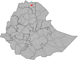
| Country | |
| Region | |
| Zone | Maekelay Zone (Central) |
| Area | |
| • Total | 2,360.17 km2 (911.27 sq mi) |
| Population (2007) | |
| • Total | 146,104 |
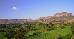
Werie Lehe (Tigrinya: ወርዒ ለኸ) was one of the woredas in the Tigray Region of Ethiopia. Part of the Maekelay Zone, Werie Lehe was bordered on the south by the Wari River which separated it from Kola Tembien, on the southwest by Naeder Adet, on the west by La'ilay Maychew, on the north by Adwa, on the northeast by Enticho, and on the east by the Misraqawi (Eastern) Zone.
Local landmarks in this woreda include several monolithic churches, which include Wkro Mariyam, Wkro Giyorgis and Abba Ghenzay near Nebelet.[1] Another site of archeological interest is Henzat Gabriel, 52 kilometers southeast of Adwa, where local traditions claim around 160 stelae from Aksumite times are buried in and around the compound of the local church.[2]
- ^ Descriptions of these three can be found in Ruth Plant with David Buxton, "Rock-hewn Churches of the Tigre Province", Ethiopia Observer, 13 (1970), pp. 264-266.
- ^ Yohannes Gebre Selassie, "New data on ‘GZ, Son of a King, From a 3d c. AD Unvocalized Gәᶜәz Inscription (Ḥәnzat, Tәgray)", Annales d'Ethiopie, 29 (2014), pp. 13-25