30°31′14″S151°40′45″E / 30.520560°S 151.679192°E / -30.520560; 151.679192 (West end)
General information
Type
Rural road
Length
169.8 km (106 mi)[3]
Gazetted
August 1928 (as Main Roads 119 and 120)[1] March 1938 (as Trunk Road 76)[2]
Route number(s)
B78 (2013–present)
Former route number
State Route 78 (1974–2013)
Tourist routes
Tourist Route 17 (Ebor–Armidale)
Major junctions
East end
Giinagay Way Raleigh, New South Wales
Pacific Highway
Armidale Road
Guyra Road
West end
New England Highway Armidale, New South Wales
Location(s)
Major settlements
Bellingen, Dorrigo, Ebor
----
Infobox instructions
guidelines
examples
talk
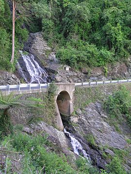
Waterfall Way is a 170-kilometre (110 mi)[3] country road in the Northern Tablelands region of New South Wales, Australia, linking Raleigh on the state's North Coast to Armidale. The route passes through some of New South Wales' most scenic countryside and has become well known as its best and Australia's third most beautiful tourist drive.[4][5] Seven national parks, of which three are listed as World Heritage Areas by UNESCO and form part of the Gondwana Rainforests of Australia (formerly the Central Eastern Rainforest Reserves), are located on or close to the route. Dorrigo National Park encompasses the waterfalls that give the route its name.
In addition to being a tourist route, the Waterfall Way is also an important link between coastal and inland New South Wales (specifically the population centres of Armidale and Coffs Harbour), and is therefore heavily trafficked.
^"Main Roads Act, 1924–1927". Government Gazette of the State of New South Wales. No. 110. 17 August 1928. pp. 3814–20. Archived from the original on 3 August 2022. Retrieved 1 August 2022 – via National Library of Australia.
^"Main Roads Act, 1924–1937". Government Gazette of the State of New South Wales. No. 46. National Library of Australia. 25 March 1938. p. 1222. Archived from the original on 29 November 2022. Retrieved 29 November 2022.
^ abGoogle (24 March 2018). "Waterfall Way" (Map). Google Maps. Google. Retrieved 24 March 2018.
WaterfallWay is a 170-kilometre (110 mi) country road in the Northern Tablelands region of New South Wales, Australia, linking Raleigh on the state's...
reliable references. There is no standard way to measure the height or width of a waterfall. No ranking of waterfalls should be assumed because of the heights...
following are lists of waterfalls in the world by height, classified into two categories — natural and artificial. Natural waterfalls are further subdivided...
from Killarney in County Kerry, Ireland. The waterfall is a popular site on the Ring of Kerry and the Kerry Way tours. The word Torc is from the Irish translation...
The waterfall model is a breakdown of development activities into linear sequential phases, meaning they are passed down onto each other, where each phase...
Madhe Ghat is a waterfall located in Maharashtra state India around 62 km south west of Pune bordering Raigad district and in the vicinity of Torna Fort...
A waterfall chart is a form of data visualization that helps in understanding the cumulative effect of sequentially introduced positive or negative values...
kilometres (6.2 mi) off the WaterfallWay and 565 kilometres (351 mi) north of Sydney. The 25-kilometre (16 mi) Styx River Forest Way runs from the Point Lookout...
Cheonjiyeon Waterfall (Korean: 천지연폭포) is a waterfall on Jeju Island, South Korea. It is 22 m (72 ft) high and 12 m (39 ft) wide. It is one of the main...
Sydney and Brisbane at the junction of the New England Highway and WaterfallWay. Before the British colonial settlement of New South Wales, the indigenous...
Waterfall is a waterfall of Telangana state in India, located on Kadam river in Neradigonda mandal of Adilabad district. It is the highest waterfall in...
Jeongbang Waterfall (Korean: 정방폭포) is a waterfall and popular tourist attraction located in Seogwipo, Jeju Province, South Korea. The waterfall is 23 m...
Australia, 580 kilometres (360 mi) north of Sydney on Dome Road off the WaterfallWay, 5 kilometres (3.1 mi) east of the town of Dorrigo. Dorrigo National...
coordinates) This is a list of waterfalls in Australia. Wallaman Falls in Queensland are Australia's tallest permanent waterfall with a plunge of nearly 300...
language. There is also a temple of Saraswati on the way to Lele from the fall. List of waterfalls of Nepal "MANIKHEL-SIMBA FALLS-Sightseeing-Nepal". Nepal...
Kintampo waterfalls is one of Ghana' highest waterfalls located in Bono East. It was formerly known as Sanders Falls during the colonial days. It is located...
from Thodopuzha. It is located on the way to the Thommankuth Ecotourism point. During the monsoon, the waterfall rises and flows the maximum. Anayadikuthu...
"By a Waterfall" is a 1933 song with music by Sammy Fain and lyrics by Irving Kahal. It was featured in an extravagant choreographic arrangement in the...
Tumpak Sewu, also known as Coban Sewu, is a tiered waterfall that is located between the Pronojiwo District, Lumajang Regency, and the Ampelgading District...
Yooroonah Tank Barrier is a heritage-listed former tank barrier om WaterfallWay, Ebor, New South Wales, Australia. It was designed by Eastern Military...
October 31: Sixty-eight dairy cows died on a farm at Fernbrook on the WaterfallWay near Dorrigo, New South Wales, after being involved in a lightning incident...
kilometres (350 mi) north of Sydney, and 10 kilometres (6.2 mi) south of WaterfallWay, just 85 kilometres (53 mi) east of Armidale and 65 kilometres (40 mi)...
(25 mi) due east of Armidale and 1.45 kilometres (0.90 mi) off the WaterfallWay, the Wollomombi Falls are atop the Wollomombi Gorge near the confluence...
Dudhsagar Falls (lit. 'Sea of Milk') is a four-tiered waterfall on the Mandovi River in the Indian state of Goa. It is 60 km from Panaji by road and is...
following list of waterfalls of Canada include all waterfalls of superlative significance. As of 2020[update], there are 18 confirmed waterfalls with an overall...
is a tiered waterfall on the Guy Fawkes River, located near Ebor and about 37 kilometres (23 mi) north-east of Wollomombi on WaterfallWay in the New England...
 Global Information