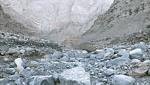
Wadi Rahabah (Arabic: وادي رحبة, romanized: Wādī Raḩbah),[1][2][3][4] is a dry valley or river with intermittent flow, which flows almost exclusively during the rainy season, located in the northeast of the United Arab Emirates, in the Emirate of Ras Al Khaimah.
It forms its own drainage basin, with an approximate area of 12.42 km2 (4.80 sq mi), to the north, it limits with the drainage basins of wadis and smaller ravines that pour their waters directly into the Persian Gulf and with the sub-basin of the Wadi Halhal, a tributary of the Wadi Ghalilah; to the east and southeast, with the Wadi Jib sub-basin, a tributary of the Wadi Shah / Wadi Shehah; to the south with the Wadi Bakhit basin;[5] and to the west with the inlet and coastal wetland of Khawr Hulaylah,[6][7] into which it flows, located in the Persian Gulf, next to the town of Seih Al Qurum (Qurm),[2][8] northwest of the town of Kabdah,[1] and north of the city of Ar Rams.[1][2]
The source of the main channel of the Wadi Rahabah is located approximately 1,350 m (4,430 ft) altitude on the western slope of Jabal Rahabah (1,543 m (5,062 ft)), one of the highest mountains in the country, almost at the foot of the Rahabah South Col (1,470 m (4,820 ft)), on the Jabal ar Rahrah Ridge.
A short distance from the wall of the great cliff that forms the western slope of Jabal Rahabah, are the ruins of an old village, with numerous dry stone constructions, and there is a small spring.
^ abc Jāmiʻat al-Imārāt al-ʻArabīyah al-Muttaḥidah. Geoprojects (U.K.) Ltd., The National atlas of the United Arab Emirates, Al Ain : United Arab Emirates University - 1993
^ abc Map of Trucial States, Muscat and Oman - Rams - Scale 1:100 000 - Published by D Survey, Ministry of Defence, United Kingdom (1971) - Edition 3-GSGS - The National Archives, London, England <https://www.agda.ae/en/catalogue/tna/fco/18/1785>
^Lancaster, William; Lancaster, Fidelity (2011). "A discussion of rock carvings in Ra's al Khaimah Emirate, UAE, and Musandam province, Sultanate of Oman, using local considerations". Arabian Archaeology and Epigraphy. 22 (2): 166–195. doi:10.1111/j.1600-0471.2011.00338.x. ISSN 1600-0471.
^Mindat.org - Wādī Raḩbah, Ra’s al Khaymah, United Arab Emirates
^FCO 8/586 - 1967-1968 Boundary between East Aden Protectorate and Muscat and Oman - The National Archives, London, England <https://www.agda.ae/en/catalogue/tna/fco/8/586/n/50>
^ Tribulus - Volume 19 - 2011 - Journal of the Emirates Natural History Group - The Flora of the Ru'us al-Jibal -the Mountains of the Musandam Peninsula: An Annotated Checklist and Selected Observations - Gary R. Feulner - Abu Dhabi, United Arab Emirates, 2011<https://enhg.org/Portals/1/trib/V19/TribulusV19.pdf>
^Mindat.org - Khawr Ḩulaylah, Ra’s al Khaymah, United Arab Emirates
^https://www.mindat.org/feature-291129.html Mindat.org - Qurm, Ra’s al Khaymah, United Arab Emirates]
WadiRahabah (Arabic: وادي رحبة, romanized: Wādī Raḩbah), is a dry valley or river with intermittent flow, which flows almost exclusively during the rainy...
ʽAmaqah ʽAmbaq ʽAmd Amrash ‘Amri An Nabat An Najd Anib ʽAqlar Ar Rabam Ar Rahabah Ar Ramad Ar Rawdah, Sanaʽa Ar Rawnah Ar Rihabi ʽAraqah ʽArjaz ʽArtam Artil...
The Wadi Ghalilah (Arabic: وادي غليلة, romanized: Wādī Ghalīlah) is a valley or dry river, with intermittent flow, which flows almost exclusively during...
WadiRahabah / Wādī Raḩbah, in Ras Al Khaimah Wadi Raibiya / Wadi Ar Rebiyyah, in Ras Al Khaimah Wadi Shaam / Wādī ash Sha‘m, in Ras Al Khaimah Wadi Abadilah...
Alternative Names: Jabal Harf Tila (major) Alternative Names: Jabal Rahabah, Jabal Raḩabah, Jabal ar Ra`aylah, Jabal ar Ra‘aylah. Alternative Names: Jabal...
northern slope of Jabal Rahabah (1,543 m) In its course, from the south and southeast, to the northwest, divided into two branches, the Wadi Halhal crosses in...
Barremian–lower Aptian of NE Arabia: The Kharaib and Shu'aiba formations in WadiRahabah and Wadi Kebdah, Ras Al Khaimah, U.A.E." Cretaceous Research. 159: 105873...
be in the mountains' recesses. The city of Tarim Hajjarin in Wadi Dawan Shibam in Wadi Hadhramaut, with mountains in the background Al-Mukalla with the...
rare rainfall to help create oasis around the springs and wells of the few wadis.[citation needed] The Hijaz Mountains have been conjectured as the source...
slopes of Jabal Al Harim are located the headwaters of the Wadi Bih, one of the most important wadis in the United Arab Emirates, which originates at this...
with hot springs and a lake. To the northeast is the mountain's largest wadi, Wadi Tarabat. The mountain has ridges which stretch northwards to the inner...
border between UAE and Oman) - Coordinates 25°41'21.4"N 56°09'30.6"E Jabal Raḩabah (1,543 m) Emirate of Ras Al Khaimah - Coordinates 25.92610°N, 56.11689°E...
however, in the Musandam Governorate, in the Sultanate of Oman. Jabal Raḩabah (Arabic: جبل رحبة) is a peak in the Hajar Mountains, northeast of the United...
year-round sub-surface in the wadis. The city of Tarim Hajjarin in Wadi Dawan Buildings in Wadi Hadhramaut Shibam in Wadi Hadhramaut, with mountains in...
south, and the Hajar to the east. Many narrow valleys (wadis) run along its sides, such as Wadi Hanifa, and a group of towns lie on its central section...
exhumation event created possibly the largest megasheath fold on Earth, the Wadi Mayh megasheath fold. The common view is that these eclogites were originally...
the drainage divide of Karsha / Wadi Khabb Shamsi. Its summit lies on the drainage divide, between the basins of the Wadi Khabb Shamsi (which pours into...
permanent rivers. Most areas are drained by ephemeral watercourses called wadis, which are dry except during the rainy season. Plentiful ancient aquifers...
by highest point List of tourist attractions in the United Arab Emirates Wadi Bih Wildlife of Oman Wildlife of the United Arab Emirates Ras Al Khaimah...
District Marib District Marib City District Medghal District Raghwan District Rahabah District Sirwah District In the 1980s, after the region was hit by floods...
between the UAE and Oman) - Coordinates 25.689278°N, 56.158500°E Jabal Rahabah (1,543 m) Ras Al Khaimah - Coordinates 25.92610°N, 56.11689°E Jabal Yibir...
رُؤُوْس ٱلْجِبَال, romanized: Capes of the Mountains). The largest wadi in Mussandam is Wadi Bih, which forms the central drainage basin. The highest Mountain...
pro-government forces with air support from the Royal Saudi Air Force, captured Rahabah District and some parts of Jabal Murad District. Source close to Hadi forces...
Emirate of Ras Al Khaimah - Coordinates 25°41'11.8"N 56°09'20.9"E Jabal Raḩabah (1,543 m) Emirate of Ras Al Khaimah - Coordinates 25.92610°N, 56.11689°E...
 Global Information