For other uses, see Egnatia Motorway; Egnatia Street, Thessaloniki; and Egnatia Street (disambiguation).
Via Egnatia / Ἐγνατία Ὁδός
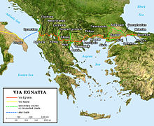
Route of the Via Egnatia
Location
Dyrrachium to Byzantium (later Constantinople)
Type
Roman road
History
Builder
Roman Republic, Gnaeus Egnatius proconsul of Macedonia
Periods
2nd century BC
Ancient Via Egnatia in Kavala (Neapolis)Remains of Via Egnatia near RadozdaVia Egnatia by Resen in North Macedonia, now part of A-3 motorway
The Via Egnatia was a road constructed by the Romans in the 2nd century BC. It crossed Illyricum, Macedonia, and Thracia, running through territory that is now part of modern Albania, North Macedonia, Greece, and European Turkey as a continuation of the Via Appia.
Starting at Dyrrachium (now Durrës) on the Adriatic Sea, the road followed a difficult route along the river Genusus (Shkumbin), over the Candaviae (Jablanica) mountains and thence to the highlands around Lake Ohrid. It then turned by parts south, following several high mountain passes to reach the northern coastline of the Aegean Sea at Thessalonica. From there it ran through Thrace to the city of Byzantium (later Constantinople, now Istanbul).[1] It covered a total distance of about 1,120 km (696 miles/746 Roman miles). Like other major Roman roads, it was about six metres (19.6 ft) wide, paved with large polygonal stone slabs or covered with a hard layer of sand.[2]
^Richard J. A. Talbert, Barrington Atlas of the Greek and Roman world: Map-by-Map Directory, p. 749. Princeton University Press, 2000. ISBN 0-691-04945-9.
^Elena Koytcheva, "Logistical problems for the movement of the early crusaders through the Balkans: transport and road systems", p. 54 in Proceedings of the 21st International Congress of Byzantine Studies, ed. Elizabeth Jeffreys. Ashgate Publishing, Ltd, 2006. ISBN 0-7546-5740-X.
The ViaEgnatia was a road constructed by the Romans in the 2nd century BC. It crossed Illyricum, Macedonia, and Thracia, running through territory that...
towards Albania either by landing at present day Durrës through the ViaEgnatia or near the ancient town of Apollonia and continue towards present day...
while Cassius was on the south of the ViaEgnatia. Antony arrived and positioned his army south of the ViaEgnatia, while Octavian put his legions north...
been dubbed a modern ViaEgnatia (in Greek, Egnatia Odos / Εγνατία Οδός). However, the parallel is not exact; the original ViaEgnatia was much longer (1...
Cassius occupied the south of the viaEgnatia. Antony arrived shortly and positioned his army on the south of the viaEgnatia, while Octavian put his legions...
800m race for children and races 5 km, 10 km. The international race 'ViaEgnatia Run' is an action of Evros Regional Unit which started in 2016 and is...
reaching Constantinople (modern Istanbul). This road was connected with ViaEgnatia by other roads: the road along the Axios (or Vardar) River, the road...
situated on the Bay of Kavala, across from the island of Thasos and on the Egnatia motorway, a one-and-a-half-hour drive to Thessaloniki (160 kilometres (99...
the Roman Republic reconstructed in the 2nd century BC as part of the ViaEgnatia. Philip II endowed the city with important fortifications, which partially...
Egypt: Via Hadriana In Mauretania Tingitana from Tingis southward (see: Roman roads in Morocco) Albania / North Macedonia / Greece / Turkey ViaEgnatia (146...
Antony in 41 BC. It grew to be an important trade hub located on the ViaEgnatia, the road connecting Dyrrhachium with Byzantium, which facilitated trade...
Egnatia can refer to: Egnatia, Ioannina, municipality in the Ioannina regional unit Egnatia, Thessaloniki, in the Thessaloniki regional unit Via Egnatia...
period, Heraclea was an important Episcopal seat and a waypoint on the ViaEgnatia that once linked Byzantium with Rome through the Adriatic seaport of...
Egnatia Street or Egnatia Odos may refer to the following roads: Egnatia Odos (modern road), a motorway in Greece ViaEgnatia, a Roman road Egnatia Street...
13 August 2012. "ViaEgnatia". Crandall University. Archived from the original on 20 March 2001. Retrieved 15 August 2012. "ViaEgnatia: a journey across...
century. Their domain stretched across the Shkumbin valley and the old ViaEgnatia road and reached east to today's Bitola. The first attested surname of...
Junkut t' Scocniis ... N'Sckoder t' Scc...pniis. Retrieved 23 July 2016 – via Internet Archive. Howe, T. (2017). "Plain tales from the hills: Illyrian...
near or within Dassaretia. In Roman times, it was located along the ViaEgnatia, which connected the Adriatic port Dyrrachion (present-day Durrës) with...
close to a junction of two branches of an important Roman road, the ViaEgnatia, which connected the Adriatic coast with Byzantium. It was one of the...
 Global Information