Neighborhood of Philadelphia in Philadelphia, Pennsylvania
Upper North Philadelphia
Neighborhood of Philadelphia
Lillian Marrero Branch of the Philadelphia Free Library is located in Upper North Philadelphia's West Kensington
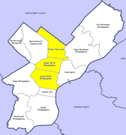
Map of Philadelphia County with North Philadelphia highlighted. Click for larger image
Country
United States of America
State
Pennsylvania
County
Philadelphia
City
Philadelphia
Area
• Total
44.4 sq mi (115 km2)
Population
(2010)
• Total
181,531
• Density
12,241/sq mi (4,726/km2)
ZIP code
19122, 19132, 19133, 19134, 19140
Upper North Philadelphia is a section of Philadelphia that is immediately north of Lower North Philadelphia, and can be described as an area that has a "...large and rapidly growing Puerto Rican population".[1]
According to the planning commission, Upper North Philadelphia officially consists of the Allegheny West, Fairhill, Glenwood, Hunting Park, and Nicetown-Tioga neighborhoods. Bounded by York Street to the south, Front Street to the east, Roosevelt Expressway to the north, and Ridge Avenue to the west.
^Guian A. McKee (15 June 2010). The Problem of Jobs: Liberalism, Race, and Deindustrialization in Philadelphia. ISBN 9780226560144.
and 16 Related for: Upper North Philadelphia information
north to south) Olney-Oak Lane, UpperNorthPhiladelphia and Lower NorthPhiladelphia. Other sections of NorthPhiladelphia include Brewerytown, Fairhill...
Fairmount Park Lower NorthPhiladelphia is a section of Philadelphia that is immediately north of Center City and below UpperNorthPhiladelphia and can be described...
Lower NorthPhiladelphia is a section of Philadelphia, Pennsylvania, that is immediately north of Center City and below UpperNorthPhiladelphia and can...
Pennsylvania and Upper Darby Township, Pennsylvania, originally owned by the Philadelphia and Western Railroad, then acquired by the Philadelphia Suburban Transportation...
Philadelphia, commonly referred to as Philly, is the most populous city in the U.S. state of Pennsylvania and the sixth-most populous city in the nation...
Northwest Philadelphia is a section of the city of Philadelphia. The official boundary is Stenton Avenue to the north, the Schuylkill River to the southwest...
NorthPhiladelphia station is an intercity rail and regional rail station on the Northeast Corridor, located on North Broad Street in the North Philadelphia...
a neighborhood located in NorthPhiladelphia section of Philadelphia, Pennsylvania, United States. South Kensington is north of Northern Liberties, south...
major intermodal transit station in Philadelphia, Pennsylvania, United States. It is metropolitan Philadelphia's main railroad station and a major stop...
The Philadelphia Main Line, known simply as the Main Line, is an informally delineated historical and social region of suburban Philadelphia, Pennsylvania...
Avenue, Philadelphia, Pennsylvania. It was under the administration of the high school system of the Roman Catholic Archdiocese of Philadelphia and its...
Heddle Manufacturing Company Complex" (PDF). Retrieved July 3, 2012. "Raging 5-Alarm Inferno Engulfs Defunct Factory in NorthPhiladelphia". May 18, 2018....
cantilevered upper deck. The ballpark's first base line ran parallel to Huntingdon Street; right field to center field parallel to North Broad Street;...
The West Philadelphia Elevated, also known as the High Line or Philadelphia High Line, is a railroad viaduct in the western part of Philadelphia, Pennsylvania...
region in both the nation and North America, and the 68th-largest metropolitan region in the world. In addition to Philadelphia, other major population centers...
 Global Information